 03-06-2007, 03:02 PM
|
#1
|
|
Senior Member
Join Date: Nov 2003
Location: Central NH
Posts: 5,253
Thanks: 1,455
Thanked 1,357 Times in 476 Posts
|
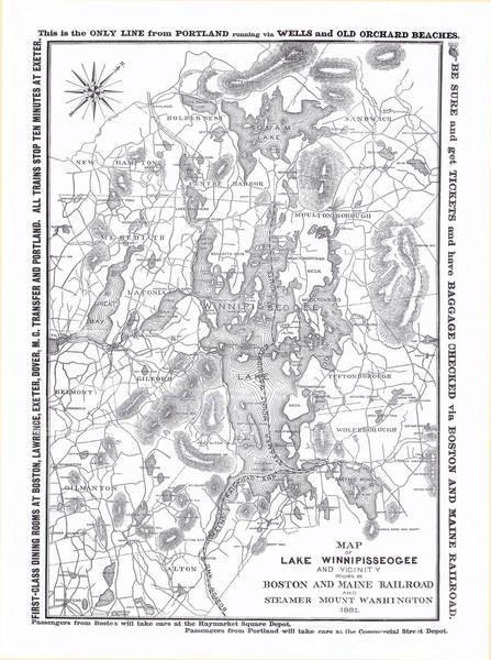
 1881 B & M Map of Lake Winnipiseogee and Vicinity
Here is one of my absolute favorite maps of our great lake, which I’ve been working on for several years now. An 1881 B & M Map of Lake Winnipiseogee and Vicinity. Unfortunately it still isn’t perfect, but I feel it is time to share it with my forum friends. It was a black and white photocopy, which I sewed back together and cleaned up. (If you ever use a copier, do yourself a favor and copy everything in the same direction. It will make piecing it back together much easier!) I also purchased a copy of the original, but someone taped the seams on the front and sadly they show and there is also the problem of where the heck to hang it! Note many different names on islands, bays and lakes.
Opechee Bay is Round Bay
Winnisquam Lake is Great Bay
Paugus Bay is Long Bay with Big Island as Goat Island
Meredith Bay is Northwest Bay
Stonedam Island is spelled Stone Damn
Fish Cove looks to me to be called Plummer’s Cove
Governor’s Island is Davis Island
Lock’s Island is Thompson’s Island
Sleeper’s Island is Little Rattlesnake
Treasure Island is Red Head Island
Moose Island seems to be Varney’s Island
Lake Wentworth is Smith’s Pond
In addition to these, what do you see that is different? Including the surrounding lakes, ponds and mountains.
(McDude, do you see Hall’s Pond?  ) )
If there is a spot on the map that is not clear enough, let me know and I will try to read it on my copies or perhaps post the small piece for you.
Enjoy. Hope you like it as much as I do!
RG
Click here for super-sized map in PhotoPost.
|

|

|