

|
|
|
|
|
|||||||
| Home | Forums | Gallery | Webcams | Blogs | YouTube Channel | Classifieds | Register | FAQ | Donate | Members List | Today's Posts | Search |
 |
|
|
Thread Tools | Display Modes |
 05-20-2005, 11:58 PM
|
#1 |
|
Senior Member
Join Date: Apr 2004
Posts: 1,325
Thanks: 5
Thanked 0 Times in 0 Posts
|
Just where on the Lake "really" is:
Last edited by GWC...; 12-08-2005 at 03:50 PM. |

|

|
|
05-21-2005, 09:10 AM
|
#2 |
|
Senior Member

Join Date: Nov 2004
Location: Bear Island
Posts: 642
Thanks: 349
Thanked 145 Times in 77 Posts
|
Is that Rattlesnake Island on the left? With the little sail boats?
__________________
Dream out loud. |
|
|
|
|
05-21-2005, 10:42 AM
|
#3 |
|
Senior Member

Join Date: Jul 2002
Location: Central MA
Posts: 2,352
Thanks: 18
Thanked 535 Times in 179 Posts
|
I don't think that is Rattlesnake on the left.. do I now have to go for a boat ride looking for the location?
Drats... a boat ride... what a chore!  The forecast is better for us out here on the island. Yesterday was glorious. Today is a bit nippier but still no rain. There is an east wind, so I will have to bundle up. I will take a picture if I find it.
__________________
Island Girl ....... Make Lemonade |
|
|
|
|
05-21-2005, 03:45 PM
|
#4 |
|
Senior Member
Join Date: Mar 2004
Location: Clifton, NJ, Alton Bay
Posts: 829
Thanks: 255
Thanked 225 Times in 131 Posts
|
The land on the left with the small sailboats visible is Black Point. If you look at the hill in the background just to the right of center, you can see the large clearing or meadow which is just above Alton Mountain Road. In the center is the mouth of Alton Bay. On the extreme right you can just see a small tip of Little Mark Island (very dark green) directly above the teak step on the gunwale.
Last edited by ghfromaltonbay; 05-21-2005 at 03:49 PM. |
|
|
|
|
05-21-2005, 04:12 PM
|
#6 |
|
Senior Member

Join Date: Nov 2002
Location: The Lakes, Central NH. and Dallas/Fort Worth TX.
Posts: 3,694
Blog Entries: 3
Thanks: 3,069
Thanked 472 Times in 236 Posts
|
The peak to the right, reminds me of Stonedam Island.... First of all, tell me somthing, are we going to get any points for the right guess to this very technical question?
 ..... After all, we have a Holliday weekend coming up, and I am already totaly off for it! ..... After all, we have a Holliday weekend coming up, and I am already totaly off for it!If you were to take a picture, down Paugus Bay way and ask the same question,..... I may never know what it is that I'm talking about,... But I will give you a snappy answere
__________________
trfour Always Remember, The Best Safety Device In The Boat, or on a PWC Snowmobile etc., Is YOU! Safe sledding tips and much more; http://www.snowmobile.org/snowmobiling-safety.html |
|
|
|
|
05-21-2005, 04:12 PM
|
#7 |
|
Senior Member

Join Date: Nov 2003
Location: Central NH
Posts: 5,252
Blog Entries: 1
Thanks: 1,451
Thanked 1,349 Times in 475 Posts
|
I agree with GHfromaltonbay, it's very similar to the On Golden Pond shot.
|
|
|
|
|
05-21-2005, 04:13 PM
|
#8 |
|
Senior Member

Join Date: Jul 2002
Location: Massachusetts
Posts: 336
Thanks: 0
Thanked 243 Times in 82 Posts
|
The description of the original photograph by Just_Sold is, "Going NW from Rattlesnake Island 6/29/04", but I think that is wrong.
My photo is looking SSW from light #22 (Littlemark Island) towards the town of Alton Bay. Note the diagonal cut in the trees in the far hill. My guess is that Just_Sold's photograph was taken about 1/2 mile south of mine. I'm not sure if the point on the left is Echo Point or Fort Point. 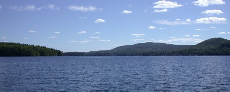
|
|
|
|
|
05-21-2005, 04:44 PM
|
#9 |
|
Senior Member
Join Date: Mar 2004
Location: Clifton, NJ, Alton Bay
Posts: 829
Thanks: 255
Thanked 225 Times in 131 Posts
|
DRH is right about the larger, clearer image in the Photopost. The large rise to the right is located very near to the scenic lookout on Route 11. You can make out the flat area where the lookout is located, but from this angle you can't see the rock formation across the road where they blasted to put thru the highway.
|
|
|
|
|
05-21-2005, 09:44 PM
|
#10 |
|
Senior Member
Join Date: Apr 2004
Location: Suncook, NH, but at The Lake at Heart
Posts: 2,615
Thanks: 1,083
Thanked 434 Times in 210 Posts
|
I stand corrected. I reviewed the photo and the one taken just before it http://www.winnipesaukee.com/photopo...cat=500&page=5 and it is looking down Alton Bay with Black Point on the Left and a touch of Little Mark on the right. I have corrected the photo comments. Sorry for any confussion.
__________________
Just Sold  At the lake the stress of daily life just melts away. Pro Re Nata |
|
|
|
|
| Bookmarks |
|
|


")


 Linear Mode

