

|
|
|
|
|
|||||||
| Home | Forums | Gallery | Webcams | Blogs | YouTube Channel | Classifieds | Register | FAQ | Members List | Donate | Today's Posts | Search |
 |
|
|
Thread Tools | Display Modes |
|
|
 07-01-2009, 08:14 AM
|
#1 |
|
Senior Member
Join Date: May 2004
Location: Weirs Beach
Posts: 1,974
Thanks: 80
Thanked 984 Times in 443 Posts
|
Just got a Garmin Nuvi 500...
What a slick little unit! It is Garmins version of a do it all GPS... Car, Boat, Hike, Bike etc. Small, accurate and waterproof.... and Garmin sells a pretty good map of Lake Winni you can download for $9.99! I am VERY happy with this unit!! Woodsy
__________________
The only way to eliminate ignorant behavior is through education. You can't fix stupid. |

|

|
|
07-01-2009, 08:45 AM
|
#3 |
|
Senior Member
Join Date: Jun 2004
Location: Alton Bay
Posts: 74
Thanks: 1
Thanked 6 Times in 6 Posts
|
I have the same unit but have not used it on the boat yet. Where did you get the map of the lake to download, was it on garmins site? I have used it snowmobiling and it worked great. It is a super all around gps, great for off road use.
|
|
|
|
|
07-01-2009, 08:52 AM
|
#4 |
|
Senior Member
Join Date: May 2004
Location: Weirs Beach
Posts: 1,974
Thanks: 80
Thanked 984 Times in 443 Posts
|
Here is the link to the Garmin Lake Winni map.... the screenshots looked good so I bought it! I figured for $9.99 how could ya go wrong? Especially considering the Bizer version is $110 or $124 if you dont already have the MicroSD card
https://buy.garmin.com/shop/shop.do?...400&pvID=37702 Hope this helps! Woodsy
__________________
The only way to eliminate ignorant behavior is through education. You can't fix stupid. |
|
|
|
|
07-01-2009, 09:38 AM
|
#5 |
|
Senior Member
Join Date: Feb 2008
Location: Gilford, NH / Welch Island
Posts: 6,537
Thanks: 2,455
Thanked 5,468 Times in 2,143 Posts
|
Hi Woodsy;
Does the Nuvi have tracking capabilities?? That mapping software looks great for 10 bucks! Thanks! dan |
|
|
|
| Sponsored Links |
|
|
|
07-01-2009, 09:49 AM
|
#6 |
|
Senior Member
Join Date: May 2004
Location: Weirs Beach
Posts: 1,974
Thanks: 80
Thanked 984 Times in 443 Posts
|
ishoot...
It does... It has a trip log (think breadcrumb trail) and it has a track back feature that allows you to retrace your steps... I will try to post some screen shots as soon as this !#@$ weather breaks! Woodsy
__________________
The only way to eliminate ignorant behavior is through education. You can't fix stupid. |
|
|
|
|
07-01-2009, 11:56 AM
|
#7 |
|
Senior Member
Join Date: May 2006
Posts: 283
Thanks: 1
Thanked 66 Times in 38 Posts
|
I am very interested in seeimg some screen shots too. Some detailed shots when zoomed in. I am also curious if you find the markers are acuratly depicted too...
|
|
|
|
|
07-01-2009, 01:54 PM
|
#8 |
|
Senior Member

Join Date: Sep 2003
Posts: 1,943
Thanks: 23
Thanked 111 Times in 51 Posts
|
I note that the lake chart is supposed to work with our Nuvi 260. For $10 I'll have to give it a try. Still I wonder if these auto GPS units can do waypoints and routes like a marine GPS/chartplotter ? Breadcrumbs are good but having a set of routes to follow through the tricky markers (especially if the prefered route lines aren't displayed) is better yet. I wonder if you could use the custom POI feature and then navigate from POI to POI ?
__________________
Mee'n'Mac "Never attribute to malice that which can be explained by simple stupidity or ignorance. The latter are a lot more common than the former." - RAH |
|
|
|
|
07-01-2009, 02:25 PM
|
#9 |
|
Senior Member
Join Date: May 2004
Location: Weirs Beach
Posts: 1,974
Thanks: 80
Thanked 984 Times in 443 Posts
|
M&M...
I just turned the unit on in the GPS simulation mode, (boating) and the Garmin Map does show a white line preffered navigation course through the bouys up in the graveyard... they also show a course through the bouys at the witches... Woodsy
__________________
The only way to eliminate ignorant behavior is through education. You can't fix stupid. |
|
|
|
|
07-02-2009, 01:51 PM
|
#10 |
|
Senior Member

Join Date: May 2005
Location: Isola Gatto Nero
Posts: 697
Thanks: 162
Thanked 263 Times in 81 Posts
|
Thanks Woodsy!
I just downloaded it and it looks great. Can't wait to give it a try once this weather breaks. I had tried Bizer's map on my nuvi 350 but because it is not designed as a marine unit the buoy colors where not differentiated, which made it somewhat less than useful. Here is a screen shot from the Bizer demo on the my nuvi 350. 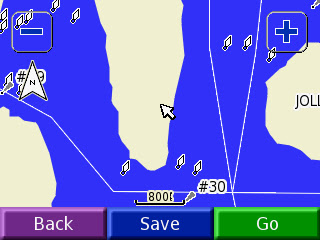 Garmin's map gets around that by showing the black buoys as black dots and the red buoys as white circles. Here's a screen shot of the Black Cat Shoals 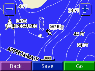 Still not perfect but certainly worth $10.
__________________
La vita è buona su Isola Gatto Nero Last edited by Gatto Nero; 07-02-2009 at 05:31 PM. |
|
|
|
|
07-02-2009, 04:53 PM
|
#11 |
|
Junior Member

Join Date: Aug 2004
Posts: 8
Thanks: 1
Thanked 10 Times in 3 Posts
|
Gatto...I also have a Nuvi 350 for my car. When you use the 350 on the lake do you just use it for your current position, or with the map install will it set preferred routes for you? I have been boating on the lake for 4 years using a chart without any problems, but never thought of using my vehicle GPS on the boat. I have considered buying a gps for the boat but just haven't bitten the bullet yet. If the 350 will plot preferred routes, I'll just use that!
|
|
|
|
|
07-02-2009, 05:09 PM
|
#12 |
|
Senior Member

Join Date: Jan 2003
Location: Alton Bay
Posts: 5,616
Blog Entries: 2
Thanks: 2,483
Thanked 1,988 Times in 1,088 Posts
|
My Garmin 550c has the Bizer Map in it, and the buoys are marked bw or rw for black or red. I set my dock as a favorite (Parker Marine), and while north of Rattlesnake heading roughly toward towards the Weirs, I hit favorite, selected dock, and said go. It said (and actually said, because it does have text to speech) "Drive to highlighted route, and then turn left." . The highlighted route, of course, was route 11. I do not think any of the Nuvi auto units will do routes and waypoints, but the crossover model(s) probably will. Just my experience, and humble opinion.
__________________
I Live Here... I am always UPTHESAUKEE !!!! |
|
|
|
|
07-02-2009, 05:25 PM
|
#13 | |
|
Senior Member
Join Date: May 2005
Location: Isola Gatto Nero
Posts: 697
Thanks: 162
Thanked 263 Times in 81 Posts
|
Quote:
__________________
La vita è buona su Isola Gatto Nero |
|
|
|
|
|
07-03-2009, 08:48 AM
|
#14 |
|
Senior Member

Join Date: Jul 2005
Location: Berlin, Ma / Gilford
Posts: 1,936
Thanks: 452
Thanked 603 Times in 340 Posts
|
Maybe I'm missing something here and you all can help me out........
I too use a GPS ..... what I'm failing to understand is -- If you have the lake markers properly depicted (and theroticaly know where your going). Why is the "route" (or for that matter the breadcrumb function) so important?? And yes, I drive extensively at night -- probably the only time when I actually pay any attention to the GPS --other than perhaps trying to find a particular marker in the sunlight glare or extremely choppy waters. If you are relying on a "route" -- sounds to me that you shouldn't be out there. Again, not attacking anyone here ....just failing to understand (a mind is a terrible thing to waste -and I've burnt way too many brain cells over the years  ) )
__________________
A bad day on the Big Lake (although I've never had one) - Still beats a day at the office!! |
|
|
|
|
07-03-2009, 09:16 AM
|
#15 | |
|
Senior Member
Join Date: Mar 2008
Location: Welch Island and The Taylor Community
Posts: 3,388
Thanks: 1,260
Thanked 2,148 Times in 983 Posts
|
Quote:
We have had at least one occasion when we had to take a person to the mainland at night in fog and rain and it was real nice to be able to follow the stored route as a check on the compass. |
|
|
|
|
|
07-06-2009, 07:53 AM
|
#16 |
|
Senior Member
Join Date: Jul 2005
Location: Berlin, Ma / Gilford
Posts: 1,936
Thanks: 452
Thanked 603 Times in 340 Posts
|
Slickcraft -- I'll give you that one!
I did forget about the foggy mornings I've experanced in the Fall .... to be honest, a couple of times I've totaly reversed direction back out of thick banks --- my fear is not in where I'm going (but being a "little guy" with no sophisticated radar) I fear the BIG guy whose trucking along in the merk oblivious! My point simply is I think too much is made of the "Route" function. I know some folks that use the "route" function to simply get from Paugus Bay to Wolfboro (in the DAYTIME!!)
__________________
A bad day on the Big Lake (although I've never had one) - Still beats a day at the office!! |
|
|
|
|
07-06-2009, 01:17 PM
|
#17 |
|
Senior Member
Join Date: May 2004
Location: Weirs Beach
Posts: 1,974
Thanks: 80
Thanked 984 Times in 443 Posts
|
Used the Nuvi 500 on the lake friday & saturday. It aquired the sattelites very quickly (esp comapared to my CP-160) Its accuracy was pretty impressive, according to the unit, the GPS signal was accurate to within 16 feet even under all that cloud cover (I kept checking the accuracy randomly throughout the dayit ranged from 12 to 26 with an average of 16) The Garmin Winni map was pretty accurate at least going by the different markers it sure seemed it. The red and black markers are pretty clearly delineated. The screen is a little small compared to my CP-160... but you can see it in the bright sunlight. The suction mount Garmin gives you worked well on the fiberglass dash of my boat. The speedometer function was pretty handy too..
All in all I am very pleased with the unit! Woodsy (I forgot the screenshots I will try to remember to take some next time)
__________________
The only way to eliminate ignorant behavior is through education. You can't fix stupid. |
|
|
|
|
07-06-2009, 03:27 PM
|
#18 |
|
Senior Member
Join Date: Jul 2005
Location: Berlin, Ma / Gilford
Posts: 1,936
Thanks: 452
Thanked 603 Times in 340 Posts
|
Thanks Woodsy --
What you just gave in your last post has thrown me "over the fence"!! Anyone want a Nuvi 255W slightly used  I'll let it go cheap.. lol I'll let it go cheap.. lol
__________________
A bad day on the Big Lake (although I've never had one) - Still beats a day at the office!! |
|
|
|
|
07-26-2009, 04:40 PM
|
#19 |
|
Senior Member
Join Date: Jun 2004
Location: Alton Bay
Posts: 74
Thanks: 1
Thanked 6 Times in 6 Posts
|
Looking for help, I loaded the winni map onto my Garmin Nuvi 500 last week. I don't seem to be getting any detail, all I see is a brown outline of the lake and a boat icon, there are no markers shown at all. I does give gps position but that's it. I've been in touch with Garmin tech support with not help. Is there a trick to getting it to work that is not in their instructions. Any help would be appreciated.

|
|
|
|
|
07-26-2009, 05:10 PM
|
#20 | |
|
Senior Member
Join Date: Feb 2008
Location: Gilford, NH / Welch Island
Posts: 6,537
Thanks: 2,455
Thanked 5,468 Times in 2,143 Posts
|
Quote:
Click on "tools", then click "settings", then click "system", then click on "usage mode" and make sure your in boating mode. Hope this helps! Dan |
|
|
|
|
|
07-26-2009, 05:18 PM
|
#21 |
|
Senior Member
Join Date: Jun 2004
Location: Alton Bay
Posts: 74
Thanks: 1
Thanked 6 Times in 6 Posts
|
i did make sure it is in boating mode and that the map is checked off in the map info screen.
thanks |
|
|
|
|
07-26-2009, 07:07 PM
|
#22 | |
|
Senior Member
Join Date: Feb 2008
Location: Gilford, NH / Welch Island
Posts: 6,537
Thanks: 2,455
Thanked 5,468 Times in 2,143 Posts
|
Quote:
I hope you figure it out! Dan |
|
|
|
|
|
08-11-2009, 06:41 AM
|
#23 | |
|
Senior Member
Join Date: May 2005
Location: Isola Gatto Nero
Posts: 697
Thanks: 162
Thanked 263 Times in 81 Posts
|
Quote:
__________________
La vita è buona su Isola Gatto Nero |
|
|
|
|
|
08-05-2009, 02:01 PM
|
#24 |
|
Junior Member
Join Date: Aug 2009
Posts: 8
Thanks: 0
Thanked 0 Times in 0 Posts
|
Woodsy
I hope you are right. you sound knowledgeable so i purchased one from amazon along with the download from garmin. too bad i won't have it for next week but i'm looking forward to trying it. the great things about these forums is the stuff you learn from people thanks |
|
|
|
|
08-10-2009, 10:51 AM
|
#25 |
|
Member
Join Date: Jan 2006
Posts: 27
Thanks: 1
Thanked 0 Times in 0 Posts
|
I've got the nuvi500, too. I bought mine last winter from REI.com. I paid around $270 for it. I wish I had seen this thread before I bought the Garmin Northeast inland lakes map for about $80 from ebay. $10 would have been better and $80...oh well...
But, I am pleased with the unit itself. The "bread crumbs" feature is really nice to have. A couple weeks ago, I took some friends back to the island home that they were renting around dusk. By the time I headed back home it was fully dark, and the bread crumbs allowed me to trace back along the same route that I had followed going in. While not my primary means of navigation, the little unit did help make it easy to find the path back. All in all, I have no issues with the 500. My wife uses it in her car like a "normal" GPS in the off season. The only feature that my unit doesn't have is the text to speech feature that speaks street names, though I may have read somewhere that the latest 500 version now has this feature. longisland60 |
|
|
|
|
08-10-2009, 07:26 PM
|
#26 |
|
Senior Member
Join Date: Jun 2009
Location: SE Mass / Lake
Posts: 125
Thanks: 99
Thanked 102 Times in 22 Posts
|
recieved the Nuvi 760 series as a 62nd birthday give last winter.. only comes with a usage setting of Auto / Bicycle or Pedestrian ..... no boat. Looks like the 760 is not designed for the boat ..... So I need to get a 500 series to have the Lake map or am I missing something here.
|
|
|
|
|
08-12-2009, 09:36 PM
|
#27 | |
|
Junior Member

Join Date: Jan 2008
Posts: 18
Thanks: 0
Thanked 2 Times in 2 Posts
|
Quote:
I can not select "Boat mode" on my unit either, although I went to the Garmin site and dowloaded a boat Icon. To see the recommended navigational paths, you need to try different zoom levels. Markers show up etc.. I don't think I have a "breadcrumb" feature however. |
|
|
|
|
|
| Bookmarks |
|
|


 Hybrid Mode
