

|
|
|
|
|
|||||||
| Home | Forums | Gallery | Webcams | Blogs | YouTube Channel | Classifieds | Register | FAQ | Members List | Donate | Today's Posts | Search |
 |
|
|
Thread Tools | Display Modes |
|
|
 10-17-2010, 11:43 AM
|
#1 |
|
Senior Member

Join Date: May 2009
Location: Moultonboro
Posts: 519
Thanks: 185
Thanked 229 Times in 120 Posts
|
"On August 3, 1852 on Lake Winnipesaukee in NH, a crew race between Harvard and Yale was the very first intercollegiate athletic event in the US."
I had no idea...any other fun facts about the lake? |

|

|
|
10-17-2010, 12:47 PM
|
#2 |
|
Senior Member
|
In 1822, the Lakeport Dam was built in Laconia and it raised the Lake Winnipesaukee water level by about 18 feet. Prior to that, Lake Winnipesaukee was about seven or eight smaller lakes that were interconnected by a natural downstream flow of water from Lee's Mills to Moultonborough to Melvin Village to the broads to the Weirs, to Paugus Bay, to the Lakeport Dam in Laconia, and over the dam and into the Winnipesaukee River. A lot of water has gone over that dam since 1822! Lake Winnipesaukee contains about 75-billion gallons of very fresh water and is about 22 miles long.
Starting in the 1820's, using water power from the Lakeport Dam, Laconia used to be a world famous mill town that produced cotton material for clothing, and railroad cars/street cars for use in railroads/trolley systems around the U.S.
__________________
 .... Banned for life from local thrift store! .... Banned for life from local thrift store!
|
|
|
|
| The Following User Says Thank You to fatlazyless For This Useful Post: | ||
RailroadJoe (10-17-2010) | ||
|
10-17-2010, 01:12 PM
|
#3 | ||
|
Senior Member

Join Date: Nov 2003
Location: Central NH
Posts: 5,253
Blog Entries: 1
Thanks: 1,455
Thanked 1,357 Times in 476 Posts
|
Quote:
Please visit the History of the Lake Size thread. Quote:

|
||
|
|
|
| The Following 4 Users Say Thank You to Rattlesnake Gal For This Useful Post: | ||
|
10-17-2010, 06:09 PM
|
#5 | |
|
Senior Member

Join Date: Apr 2004
Location: Laconia, NH
Posts: 1,284
Thanks: 409
Thanked 155 Times in 40 Posts
|
Quote:

__________________
Never waste time lamenting what was. Simply celebrate what is!
|
|
|
|
|
| Sponsored Links |
|
|
|
10-17-2010, 09:08 PM
|
#6 |
|
Senior Member
Join Date: Oct 2002
Location: Hermit Cove
Posts: 354
Thanks: 20
Thanked 68 Times in 40 Posts
|
That was going to be my line!!! Great info RG! Did you say you saved all these maps since you were a little girl??

|
|
|
|
|
10-18-2010, 05:27 AM
|
#7 | |
|
Senior Member

Join Date: Jan 2005
Location: Florida (Sebring & Keys), Wolfeboro
Posts: 6,028
Thanks: 2,285
Thanked 789 Times in 564 Posts
|
Quote:
|
|
|
|
|
|
10-18-2010, 07:52 AM
|
#8 |
|
Senior Member

Join Date: Apr 2004
Posts: 5,075
Thanks: 215
Thanked 903 Times in 509 Posts
|
I DAMand that FLL be banned from posting facts.

__________________
SIKSUKR |
|
|
|
| The Following User Says Thank You to SIKSUKR For This Useful Post: | ||
Rattlesnake Guy (10-18-2010) | ||
|
10-18-2010, 08:26 AM
|
#9 |
|
Senior Member

Join Date: Oct 2004
Location: Laconia NH
Posts: 5,669
Thanks: 3,285
Thanked 1,132 Times in 814 Posts
|
At one time, there was a cleft in Lakeport that diverted the flow of water out of Alton to the sea. Pretty much the path of Merrymeeting River. The lake was much bigger then. Lily Pond in Gilford was part of the big lake.
When the cleft broke in prehistoric times, the lake settled to the current depth minus about 20 feet before the dam was built. Cattle Landing was named because it was shallow enough to walk cattle from the mainland to Bear island. When they built the dam, Endicott Rock would have been under water. It was moved from to its present location for all to enjoy as well as protect it from the weather. The dam was built by the mills in Lowell Mass to ensure they have plenty of water to power the mills at all time. The dam also benefits mills along the Merrimack River.
__________________
Someday may never be an actual day. |
|
|
|
|
10-18-2010, 09:21 AM
|
#10 |
|
Senior Member
|
Well, as the saying goes, a picture is worth a thousand words, and a map is very similar to a picture, so that makes a map an excellent source of information.
My basis for what I said was a vague recollection from a few years back found on a google search on the Lakeport Dam.....just off the top of my head as I was running late and heading out the door.....so definately some more dam research is needed here to investigate this hypothicized 18' height increase made by the 1822 building of the dam. Thankyou in advance Rattlesnake Gal.
__________________
.... Banned for life from local thrift store!
|
|
|
|
|
10-18-2010, 09:29 AM
|
#11 | |
|
Member
Join Date: Mar 2009
Posts: 32
Thanks: 28
Thanked 0 Times in 0 Posts
|
Quote:
__________________
As you slide down the banisters of life may the splinters never point the wrong way. |
|
|
|
|
|
10-18-2010, 10:36 AM
|
#12 |
|
Senior Member
|
Now, just hold on there a minute, because I still accurately claim that the Lakeport Dam, built in 1822, raised the water level by 18 feet.
This dam construction is the origin of Lake Winnipesaukee as it has existed from 1822 till today. When I say 1822, let me readjust that just a little to include the time period from 1822 till about 1827 as the time when the dam was built up to a height similar to its' existing size today. The dam changed everything on the lake. It changed it from a group of about 7 - 8 smaller lakes into one large lake, and I can back this up with some good reference research, but not right now. I got to get going and haven't got the time right now.........so.....later....alligator!
__________________
.... Banned for life from local thrift store!
|
|
|
|
| The Following User Says Thank You to fatlazyless For This Useful Post: | ||
RailroadJoe (10-18-2010) | ||
|
10-18-2010, 12:12 PM
|
#13 | ||
|
Senior Member

Join Date: Jul 2002
Location: Massachusetts
Posts: 338
Thanks: 0
Thanked 250 Times in 83 Posts
|
Quote:
Quote:
Last edited by Bizer; 10-23-2010 at 08:11 AM. |
||
|
|
|
| The Following User Says Thank You to Bizer For This Useful Post: | ||
RI Swamp Yankee (10-18-2010) | ||
|
10-18-2010, 02:31 PM
|
#14 | |
|
Senior Member
Join Date: Apr 2004
Posts: 5,075
Thanks: 215
Thanked 903 Times in 509 Posts
|
Quote:
__________________
SIKSUKR |
|
|
|
|
|
10-18-2010, 02:55 PM
|
#15 |
|
Senior Member
Join Date: Apr 2004
Location: NH
Posts: 2,689
Thanks: 33
Thanked 439 Times in 249 Posts
|
I think we should remember that without a dam the level of the lake was far from the stable values we have today. Today the lake varies less than 2 feet over the year. Without a dam the level would vary much more.
Maybe during dry years or at the end of summer, the channel between the main lake and Paugus bay got very shallow. We've all seen the drawings of Indians trapping fish there in the original wiers. As the lake water dropped below the bottom of the channel the lake had no exit, so it would fill until the level rose. There maybe other areas with similar natural dams. I doubt very much the average lake level was 18 feet lower in 1822, there is too much contrary eveidence, and FLL never backs his "facts". But I could believe that the water varied 18 feet in those years, between spring flooding and a very dry fall. I have no facts just my guesses. |
|
|
|
|
10-18-2010, 05:17 PM
|
#16 |
|
Senior Member

Join Date: Nov 2007
Location: Effingham
Posts: 408
Thanks: 37
Thanked 19 Times in 15 Posts
|
I believe FLL always has his dam facts correct and we should all take his words as gospel.
")
|
|
|
|
|
10-18-2010, 07:21 PM
|
#17 |
|
Senior Member
Join Date: Jun 2008
Location: Portsmouth. RI
Posts: 2,231
Thanks: 400
Thanked 460 Times in 308 Posts
|
If we had had the environmentalist whackos we have today..back in 1822, the lake would be just a few "Duck Puddles" now. Just sayin
 NB NB
|
|
|
|
|
10-18-2010, 07:59 PM
|
#18 |
|
Senior Member

Join Date: Nov 2002
Location: The Lakes, Central NH. and Dallas/Fort Worth TX.
Posts: 3,694
Blog Entries: 3
Thanks: 3,067
Thanked 472 Times in 236 Posts
|
Credit Wikipedia...
http://en.wikipedia.org/wiki/Lake_Winnipesaukee Terry __________________________________________
__________________
trfour Always Remember, The Best Safety Device In The Boat, or on a PWC Snowmobile etc., Is YOU! Safe sledding tips and much more; http://www.snowmobile.org/snowmobiling-safety.html |
|
|
|
|
10-18-2010, 09:52 PM
|
#19 |
|
Senior Member
|
From memory, I recall the winni divers guy saying that the old shoreline is visable underwater and is eighteen feet down below. So, it's right there, down there, 18' down below, etched into the underwater terrain, for all to see. Suggest you take a deep breath and go jump in the lake tomorrow to investigate.....ha ha....only kidding.....will check it out myself and report back with some prima facia evidence on b&w film and post it here!
!www.lakeportnh.org www.weirsbeach.com/topten/reason9frame.html www.winnipesaukee.co/forums/showthread.php?t=931 Ok...listen up....tomorrow at 9-am, there will be a 100-question pop quiz on these three Lakeport Dam related websites. Any results lower than an 80 get you flunked plus you'll have to go find the same number as your flunking grade in cigarette butts from off of the beach at Weirs Beach! That means.....receive a 78....you need to produce 78 grubby cigarette butts.....understand!
__________________
.... Banned for life from local thrift store!
Last edited by fatlazyless; 10-18-2010 at 10:37 PM. |
|
|
|
|
10-18-2010, 11:03 AM
|
#20 |
|
Senior Member
Join Date: Jul 2004
Posts: 658
Thanks: 121
Thanked 283 Times in 98 Posts
|
I once heard that the old horse boats and barges used to be beached up in the top of Braun Bay late in the year. The Lake level then went down and they spent the winter there, ice free.
There is some small wreckage by the no rafting zone which I found as a kid. For the life of me it looks(ed) like the side cabins of a horse barge. Maybe it's just a couple of bob houses or out houses. 'Don't know. It's a fun swim. About eight feet of H2O. In a line between the little cove at the top of the bay and the little cottage on the point on the east side of the cove. About 300 feet from the east shore. Misty Blue |
|
|
|
|
10-22-2010, 06:30 PM
|
#21 | |||
|
Senior Member
Join Date: Nov 2003
Location: Central NH
Posts: 5,253
Blog Entries: 1
Thanks: 1,455
Thanked 1,357 Times in 476 Posts
|
Quote:
Quote:
Quote:
Lake Winnipesaukee Watershed |
|||
|
|
|
|
10-18-2010, 12:58 PM
|
#22 | |
|
Senior Member

Join Date: Jul 2002
Location: North Kingstown RI
Posts: 688
Thanks: 143
Thanked 83 Times in 55 Posts
|
Quote:
 .. ..
__________________
Gene ~ aka "another RI Swamp Yankee" |
|
|
|
|
|
10-22-2010, 03:11 PM
|
#23 | |
|
Moderator

|
Quote:
According to Bizer, these are the 5 largest islands on the lake in alphabetical order: Bear, Cow, Governors, Long, Rattlesnake Can you put them in the correct order, largest to smallest? Answer below. Long=1186 (acres); Bear=780; Cow=522; Governors=504; Rattlesnake=368 Anyone else surprised by the answers? |
|
|
|
|
|
10-22-2010, 04:26 PM
|
#24 |
|
Senior Member
Join Date: Jul 2004
Posts: 658
Thanks: 121
Thanked 283 Times in 98 Posts
|
Grant:
I too have never seen any sign of "man" which would indicate a shoreline in 15feet of water. But we did find... A dear old pal of mine (and member) and I were snorkeling around Glines Island about ten years ago and found a most interesting structure. A fire pit. Yup, a fire pit in about five feet of water about 30-40 feet off of the western shore of the island. This thing was not an accident. I had to be purposely made. It was (is) old. Now maybe someone decided to build a fire pit underwater or maybe it is not a fire pit at all but had some other purpose. I don't know. But if I were to guess I would say that if the Lake were five feet lower it would make a great SHORE SIDE fire pit. Misty Blue. |
|
|
|
| The Following 3 Users Say Thank You to Misty Blue For This Useful Post: | ||
|
10-27-2010, 05:13 PM
|
#25 | |
|
Senior Member
Join Date: Nov 2003
Location: Central NH
Posts: 5,253
Blog Entries: 1
Thanks: 1,455
Thanked 1,357 Times in 476 Posts
|
Quote:
Rattlesnake Island is much taller than all the other islands and if you use this Land to Acre Conversion Calculator, it comes up with a certain number. This doesn't seem to take into account the height of the land. Am I just confused? More Commonly Known Fun Facts: Rattlesnake Island is the tallest island in the lake. According to Bruce Heald's book, Lake Winnipesaukee, it is 390' above lake level. Lake Winnipesaukee is 504' above sea level. Last edited by Rattlesnake Gal; 10-27-2010 at 07:05 PM. |
|
|
|
|
|
10-27-2010, 05:49 PM
|
#26 |
|
Senior Member
Join Date: Oct 2004
Location: Laconia NH
Posts: 5,669
Thanks: 3,285
Thanked 1,132 Times in 814 Posts
|
LOL!
Many folks did not know that Rattlesnake Island is part of the Belknap Mountain range. Eons ago it was a volcano like the Ossipee Mountain range. 
__________________
Someday may never be an actual day. |
|
|
|
|
10-27-2010, 07:03 PM
|
#27 | |
|
Senior Member
Join Date: Nov 2003
Location: Central NH
Posts: 5,253
Blog Entries: 1
Thanks: 1,455
Thanked 1,357 Times in 476 Posts
|
Quote:
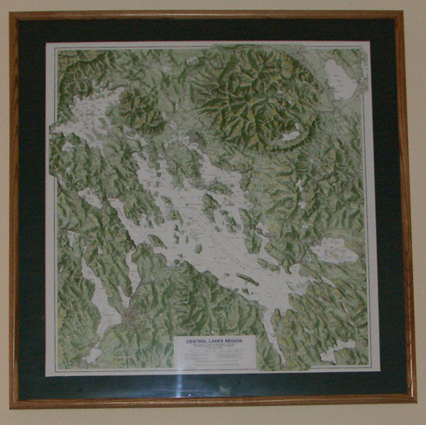 This, great for framing Duncan Press Central Lakes Region Map clearly shows both the Ossipee and Belknap volcanic ring dikes. Notice that Rattlesnake, Ship, Moose and Sleepers Islands seem to be part of this ring.  NH Geology: The Ossipee Mountain Ring Dike Complex (Scroll down.) This relief map can be purchased at The Old Country Store in Moultonborough.  The Ossipee Mountain “Ring Dike” |
|
|
|
|
|
10-27-2010, 07:58 PM
|
#28 |
|
Senior Member

Join Date: Nov 2004
Location: Bear Island
Posts: 642
Thanks: 349
Thanked 145 Times in 77 Posts
|
Can the general public climb the hill on Rattlesnake Island?
A neighbor of mine has done it a few times but I think she was friends with an owner on Rattlesnake. Thanks.
__________________
Dream out loud. |
|
|
|
|
10-28-2010, 07:56 PM
|
#30 | |
|
Senior Member

Join Date: Sep 2004
Posts: 1,254
Thanks: 423
Thanked 366 Times in 175 Posts
|
Quote:
|
|
|
|
|
| The Following User Says Thank You to Rattlesnake Guy For This Useful Post: | ||
Rattlesnake Gal (10-29-2010) | ||
|
10-29-2010, 01:46 PM
|
#31 |
|
Senior Member
Join Date: Apr 2004
Posts: 5,075
Thanks: 215
Thanked 903 Times in 509 Posts
|
Anybody else find it humerous that the RG's are responding to each other in this thread while probably sitting a few feet apart?
__________________
SIKSUKR |
|
|
|
| The Following User Says Thank You to SIKSUKR For This Useful Post: | ||
Rattlesnake Guy (10-29-2010) | ||
|
10-31-2010, 07:54 PM
|
#32 |
|
Senior Member
Join Date: Nov 2003
Location: Central NH
Posts: 5,253
Blog Entries: 1
Thanks: 1,455
Thanked 1,357 Times in 476 Posts
|
According to the Lake Winnipesaukee Historical Society,
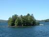
Winnipesaukee contains 274 inhabitable islands of which only 132 are one-quarter acre. Click here for the very interesting full list. It is interesting that there are: 2 - Birch IslandsAlso, interesting that many are named for animals, fish, a reptile and an arachnid BadgerThere are four islands named after loons and not a single one named for our very abundant deer!  From the Gallery of baja-mamma Next year I hope we can get pictures for Winnipesaukee.com's PhotoPost Gallery for many of our islands. (Notice how many I couldn't find photos for.) Giving them good descriptions for those of us who might be using the search feature for threads like this.
|
|
|
|
| The Following User Says Thank You to Rattlesnake Gal For This Useful Post: | ||
jkjoshuatree (10-31-2010) | ||
|
10-31-2010, 10:31 PM
|
#33 |
|
Senior Member
Join Date: Nov 2004
Location: Bear Island
Posts: 642
Thanks: 349
Thanked 145 Times in 77 Posts
|
That's it. That's all I wanted to say. RG Rocks!!!
Thanks so much for the post!! Great idea about the island pics!!! I can cover Bear Island (St. John's Church, the Old Hotel Foundation, the Mail Dock, Sunset Rock, Camp Nakomis, Camp Lawerence,, etc.) Now I have a project for next year.
__________________
Dream out loud. |
|
|
|
| The Following User Says Thank You to jkjoshuatree For This Useful Post: | ||
Rattlesnake Gal (11-01-2010) | ||
|
11-01-2010, 01:37 PM
|
#34 |
|
Senior Member
Join Date: Nov 2003
Location: Central NH
Posts: 5,253
Blog Entries: 1
Thanks: 1,455
Thanked 1,357 Times in 476 Posts
|
Next spring I will definitely start a thread for island pictures.
There's a lot of islands capture and I welcome the help to get pictures of them all. If anyone is out this winter on sleds, some winter pictures would be great too - of the islands and perhaps the towns from the ice. That is something a lot of us never get to see. It hit me last night that the list from LWHS may not be 100% accurate. They list Hen and Gypsy, which is only one island, as well as Goose Egg Rock and Rocky, which is only one island too.  Did anyone else notice any others with the same situation? If you all would, can you take a look at the list and the area of the lake you frequent? Are all the islands you know of listed? Thanks! Bizer is also looking for island names - let's help him out! |
|
|
|
|
11-01-2010, 07:09 PM
|
#35 |
|
Senior Member
Join Date: Nov 2004
Location: Bear Island
Posts: 642
Thanks: 349
Thanked 145 Times in 77 Posts
|
...I make a few trips up during the winter and can definitely take some pictures of Meredith from the ice and possibly Centre Harbor as well.
As far as names, I think Jay Island would be perfect!!
__________________
Dream out loud. |
|
|
|
|
11-08-2010, 03:51 PM
|
#36 |
|
Senior Member
Join Date: Nov 2003
Location: Central NH
Posts: 5,253
Blog Entries: 1
Thanks: 1,455
Thanked 1,357 Times in 476 Posts
|
Excerpt from Let Me Show You New Hampshire, by Ella Shannon Bowles. 1938
The Dangerous reef Witch Rocks is still to be reckoned with when navigating boats between The Weirs and the southern and eastern parts of the lake. Everything possible is done to aid pilots. In 1899 the New Hampshire Legislature authorized the placing of buoys on rocks and reefs in the lake. Today the Public Service Commission has marked three hundred hazards in Winnipesaukee by means of flashing electric lights, steady lanterns, and spar buoys. But the Great Lake is not the only one marked, for buoys are kept up on twenty-three bodies of fresh water where boating is a pastime. All motor boats and outboard motors are licensed and the fees are used to maintain buoys already up and to mark new places in other lakes. Last year 3,424 craft on ninety-six of New Hampshire's lakes, ponds, and streams were licensed, and as the fee for each is three dollars, you can figure the sum out for yourself. |
|
|
|
| The Following User Says Thank You to Rattlesnake Gal For This Useful Post: | ||
Jonas Pilot (11-08-2010) | ||
|
10-23-2010, 12:55 PM
|
#37 | |
|
Senior Member
Join Date: Jul 2002
Location: North Kingstown RI
Posts: 688
Thanks: 143
Thanked 83 Times in 55 Posts
|
Quote:
http://www.winnipesaukee.com/forums/...ead.php?t=4347
__________________
Gene ~ aka "another RI Swamp Yankee" |
|
|
|
|
| The Following User Says Thank You to RI Swamp Yankee For This Useful Post: | ||
Rattlesnake Gal (10-25-2010) | ||
|
10-25-2010, 12:31 PM
|
#38 |
|
Senior Member
Join Date: Nov 2003
Location: Central NH
Posts: 5,253
Blog Entries: 1
Thanks: 1,455
Thanked 1,357 Times in 476 Posts
|
Lake Winnipesaukee was a warm water fishery until about 1860, with yellow perch, chain pickerel, brown bullheads, shad, cusk, round and lake whitefish, brook and lake trout and alewife are to name a few.
Shad, not salmon were the fish that were trapped at The Weirs with weirs by the Native Americans. Atlantic salmon and American shad traveled up the Merrimack River for spawning in the spring. The salmon took a left in Franklin and went on to the White Mountains via the Pemigewasset River. The shad took a right to the Winnipesaukee River. Some sixty to seventy species of fish have been introduced into Lake Winnipesaukee through the last 150 years. Land locked salmon did not appear until the late 1870s. They were introduced by the hatchery in Meredith and came from the St. Croix and Penobscot Basins in Mane. Small and largemouth bass, rainbow and brown trout are some of the many fish, which were stocked. Either by individual fishermen or the state agencies, which significantly altered the Lake Winnipesaukee native fishery. |
|
|
|
|
10-25-2010, 02:11 PM
|
#39 |
|
Senior Member

Join Date: Jul 2002
Location: Pennsyltuckey, Tuftonboro, Moultonborough
Posts: 1,510
Thanks: 387
Thanked 234 Times in 128 Posts
|
Wow -- thanks for all the great info.
This could be one of my favorite threads of all time.
__________________
"When I die, please don't let my wife sell my dive gear for what I told her I paid for it." |
|
|
|
|
10-26-2010, 04:15 PM
|
#40 |
|
Senior Member
Join Date: Nov 2003
Location: Central NH
Posts: 5,253
Blog Entries: 1
Thanks: 1,455
Thanked 1,357 Times in 476 Posts
|
The Merrimack River: Its Source and its tributaries, by By J. W. Meader. 1869
Page 100 The lake abounds in fish of many varieties; the lake trout and the pickerel being the most important and valuable. Cusk are much prized by many, and perch and horned-pout may be taken at any time, by the most inexperienced angles, in quantities to suit. A variety of salt-water fish were some years since placed in this lake by experimenting parties; but as nothing was seen or know of them afterwards, it was presumed they found their level either in a watery grave, or through the channel of the Winnipesaukee and the Merrimack in a more congenial element, the briny deep. |
|
|
|
|
10-26-2010, 04:27 PM
|
#41 |
|
Senior Member
Join Date: Nov 2003
Location: Central NH
Posts: 5,253
Blog Entries: 1
Thanks: 1,455
Thanked 1,357 Times in 476 Posts
|
Winnipesaukee is an Indian name, and is derived from winne (beautiful), nipe (water), and kees (high), and auke (a place); and the Indian tribe that inhabited the territory adjacent to the lake took the name, the Winnipesaukee, as well as the lake itself, - Beautiful water of the high place.
Another interpretation has frequently been given to this word, which, entirely inaccurate, is yet exquisitely beautiful, and has, no doubt, been suggested by its eminent appropriateness: The smile of the Great Spirit. Emphatically a smile, equally to the Indian and the white man, of the Great Spirit, this lovely lake has been. Also an excerpt from: The Merrimack River: Its Source and its tributaries, by By J. W. Meader. 1869 |
|
|
|
|
| Bookmarks |
|
|


 Hybrid Mode
