

|
|
|
|
|
|||||||
| Home | Forums | Gallery | Webcams | Blogs | YouTube Channel | Classifieds | Register | FAQ | Members List | Donate | Search | Today's Posts | Mark Forums Read |
 |
|
|
Thread Tools | Display Modes |
|
|
 10-27-2010, 05:49 PM
|
#1 |
|
Senior Member

Join Date: Oct 2004
Location: Laconia NH
Posts: 5,669
Thanks: 3,285
Thanked 1,132 Times in 814 Posts
|
LOL!
 Many folks did not know that Rattlesnake Island is part of the Belknap Mountain range. Eons ago it was a volcano like the Ossipee Mountain range. 
__________________
Someday may never be an actual day. |

|

|
|
10-27-2010, 07:03 PM
|
#2 | |
|
Senior Member

Join Date: Nov 2003
Location: Central NH
Posts: 5,253
Blog Entries: 1
Thanks: 1,455
Thanked 1,357 Times in 476 Posts
|
Quote:
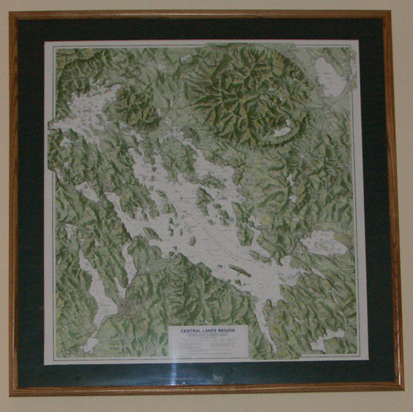 This, great for framing Duncan Press Central Lakes Region Map clearly shows both the Ossipee and Belknap volcanic ring dikes. Notice that Rattlesnake, Ship, Moose and Sleepers Islands seem to be part of this ring.  NH Geology: The Ossipee Mountain Ring Dike Complex (Scroll down.) This relief map can be purchased at The Old Country Store in Moultonborough.  The Ossipee Mountain “Ring Dike” |
|
|
|
|
|
10-27-2010, 07:58 PM
|
#3 |
|
Senior Member

Join Date: Nov 2004
Location: Bear Island
Posts: 642
Thanks: 349
Thanked 145 Times in 77 Posts
|
Can the general public climb the hill on Rattlesnake Island?
A neighbor of mine has done it a few times but I think she was friends with an owner on Rattlesnake. Thanks.
__________________
Dream out loud. |
|
|
|
|
| Bookmarks |
| Thread Tools | |
| Display Modes | |
|
|


 Hybrid Mode
