

|
|
|
|
|
|||||||
| Home | Forums | Gallery | Webcams | Blogs | YouTube Channel | Classifieds | Calendar | Register | FAQ | Donate | Members List | Today's Posts | Search |
 |
|
|
Thread Tools | Display Modes |
 09-28-2011, 03:13 PM
|
#1 |
|
Senior Member

Join Date: Jan 2011
Location: Wolfeboro
Posts: 868
Thanks: 584
Thanked 540 Times in 210 Posts
|
Driving to Tuftonboro today from Wolfeboro on 109a, I had the pleasure of seeing some very nice mountain vistas. But it got me wondering...what are all those mountains called? I'm sure they have names.
(I know Mt. Shaw and that is it) Could anyone recommend a resource (or map) that could help me identify mountains surrounding the lake and possibly beyond? I wish I could take pictures of a scenic vista and label each mountain. |

|

|
|
09-28-2011, 06:35 PM
|
#2 |
|
Senior Member
Join Date: May 2008
Location: Laconia
Posts: 479
Thanks: 545
Thanked 147 Times in 66 Posts
|
The University of New Hamshire has posted USGS maps of New England and New York. If you click on the map a larger version is displayed.
Click here: http://docs.unh.edu/nhtopos/nhtopos.htm |
|
|
|
|
09-28-2011, 07:08 PM
|
#3 |
|
Senior Member
Join Date: Jul 2009
Posts: 1,425
Thanks: 743
Thanked 788 Times in 413 Posts
|
Fascinating! One set of maps for Moultonboro is dated 1909 and another 1956. Those changes plus more recent ones are very interesting.
|
|
|
|
|
09-28-2011, 07:58 PM
|
#4 |
|
Senior Member
Join Date: Apr 2005
Location: Wolfeboro, New Hampshire is my home, 24-7-365
Posts: 1,686
Thanks: 1,047
Thanked 336 Times in 189 Posts
|
I wish they would stop moving the mountains around. It is very confusing!
|
|
|
|
| The Following 2 Users Say Thank You to Jonas Pilot For This Useful Post: | ||
bclaker (09-29-2011), Rattlesnake Guy (09-28-2011) | ||
|
09-28-2011, 08:41 PM
|
#5 |
|
Senior Member

Join Date: Apr 2004
Location: formerly Winter Harbor, still Wolfeboro
Posts: 1,181
Thanks: 299
Thanked 525 Times in 293 Posts
|
CateP - If you go to Black's Paper and Gift Shop in Wolfeboro and ask this question they will direct you to maps of the area probably able to answer your question.
A very informative map is called "Central Lakes Region" distributed by Lakes Region Association in Center Harbor. This map shows the Lake, and several smaller lakes, many mountains, and has elevations for land masses, and some marine information. It is NOT a marine navigation chart. I think you would enjoy it. |

|
|
| The Following 2 Users Say Thank You to camp guy For This Useful Post: | ||
CateP (09-28-2011), Jonas Pilot (09-28-2011) | ||
| Sponsored Links |
|
|
|
09-28-2011, 09:08 PM
|
#6 |
|
Senior Member
Join Date: Jan 2003
Location: Alton Bay
Posts: 5,597
Blog Entries: 2
Thanks: 2,453
Thanked 1,979 Times in 1,080 Posts
|
dcr is well travelled hiker who has documented his travels in our Photo Post section. Simply search "username" "dcr".
I must warn you, make sure you are comfortable with a glass of wine, or cup of tea, whatever your favorite libation may be. Dave has an extensive gallery, and it makes for interesting reading. For my money, he should publish it all in a book. Enjoy.
__________________
I Live Here... I am always UPTHESAUKEE !!!! |
|
|
|
|
09-28-2011, 09:15 PM
|
#7 |
|
Senior Member
Join Date: Apr 2005
Location: Wolfeboro, New Hampshire is my home, 24-7-365
Posts: 1,686
Thanks: 1,047
Thanked 336 Times in 189 Posts
|
... thought that. What an interesting and educational book his photos and captions would make.
|
|
|
|
|
09-28-2011, 09:53 PM
|
#8 |
|
Senior Member

Join Date: Nov 2002
Location: The Lakes, Central NH. and Dallas/Fort Worth TX.
Posts: 3,694
Blog Entries: 3
Thanks: 3,069
Thanked 472 Times in 236 Posts
|
I was lucky enough to have snowmobiled some from Paugus Bay, ( when ever the Lake Ice was safe ) and also trailered to many other trail access points around from the mid 80s.
Check out dcr's Photo Album in PhotoPost; http://www.winnipesaukee.com/photopo...php?photo=1904 Terry _____________________________
__________________
trfour Always Remember, The Best Safety Device In The Boat, or on a PWC Snowmobile etc., Is YOU! Safe sledding tips and much more; http://www.snowmobile.org/snowmobiling-safety.html |
|
|
|
|
09-29-2011, 06:05 AM
|
#9 |
|
Senior Member

Join Date: Jul 2007
Location: Moultonborough
Posts: 3,575
Thanks: 1,609
Thanked 1,632 Times in 839 Posts
|
The Country Store in Moultonborough has a raised map that is great for identifying the area mountains.
|
|
|
|
|
09-29-2011, 06:59 AM
|
#10 | |
|
Senior Member

Join Date: Mar 2003
Location: Merrymeeting Lake, New Durham
Posts: 2,226
Thanks: 302
Thanked 800 Times in 368 Posts
|
Quote:
|
|
|
|
|
|
09-29-2011, 07:29 AM
|
#11 |
|
Senior Member

Join Date: Nov 2003
Location: Central NH
Posts: 5,252
Blog Entries: 1
Thanks: 1,451
Thanked 1,349 Times in 475 Posts
|
upthesaukee is absolutely right about DCR and his gallery! I've printed many of these out to keep at the camp for quick reference.
DCR has a lots to offer. For example, did you know what Witch Hazel looks like? Have you ever seen burl out in the woods? Dave is a very knowledgeable man and we are very lucky that he shares so much with us! Here are some labeled shots of his that you may be interested in:  A View NNW from Mt Rowe - Looking over Winnipesaukee to the north. (Click on the photo once you're in the gallery to super-size it.)  View NW from Saunders Bay  View Northerly from Lincoln Park  Belknaps from Clark Point  View SW from the Bridle Path Outlook  View East from Rt 11 Viewspot  Mt Major - Looking to the NW  Oak Ridge Panorama  Labeled View from Lockes Hill 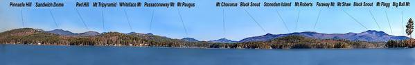 A Labeled Version of the View from the Weirs  An Annotated Version of the View from Mt Major |
|
|
|
| The Following 8 Users Say Thank You to Rattlesnake Gal For This Useful Post: | ||
angela4design (09-29-2011), bclaker (09-29-2011), GsChinadoll (09-29-2011), Jonas Pilot (09-29-2011), Lakegeezer (09-30-2011), NHBUOY (09-29-2011), upthesaukee (09-29-2011), VitaBene (09-29-2011) | ||
|
09-29-2011, 08:34 AM
|
#12 | |
|
Senior Member
Join Date: Jan 2011
Location: Wolfeboro
Posts: 868
Thanks: 584
Thanked 540 Times in 210 Posts
|
Quote:
|
|
|
|
|
|
09-29-2011, 11:29 AM
|
#13 |
|
Senior Member
Join Date: Feb 2009
Posts: 1,139
Thanks: 223
Thanked 319 Times in 181 Posts
|
One thing I have always wondered about DCR's pictures is what kind of filter is he using. Maybe he will chime in or maybe someone else knows. If it is an editing affect, I will probably pass, but would love to grab contrast like that with my slr.
|
|
|
|
|
09-29-2011, 02:16 PM
|
#14 |
|
Senior Member
Join Date: Mar 2003
Location: Merrymeeting Lake, New Durham
Posts: 2,226
Thanks: 302
Thanked 800 Times in 368 Posts
|
It appears to be post-processing via Photoshop or some other image editing program. He often greatly over-saturates colors or contrast, I assume to help accentuate ridge lines and other geographic features.
|
|
|
|
|
09-29-2011, 03:04 PM
|
#15 |
|
Senior Member
Join Date: May 2008
Location: Laconia
Posts: 479
Thanks: 545
Thanked 147 Times in 66 Posts
|
More maps. Trails.com. Topozone.com has been integrated with trails.com
Click here: http://www.trails.com/trailfinder/br...ew%20Hampshire |
|
|
|
|
| Bookmarks |
|
|


 Linear Mode

