

|
|
|
|
|
|||||||
| Home | Forums | Gallery | Webcams | Blogs | YouTube Channel | Classifieds | Register | FAQ | Donate | Members List | Today's Posts | Search |
 |
|
|
Thread Tools | Display Modes |
 05-26-2014, 06:38 PM
|
#1 |
|
Member
Join Date: May 2014
Posts: 34
Thanks: 36
Thanked 2 Times in 2 Posts
|
Hello to all of the Lake Winnipesaukee experts and enthusiasts; I'm interested to know how difficult the big lake is to learn for the new mariner.
I'm new to boating with a lake boat, I previously had a Ranger 17' bass boat that I used mainly on small lakes and rivers. My family and I are anxious to start our excursions on the lake, we just upgraded to a 24' walkaround fishing boat. My main concern is keeping my wife and daughter safe and making trips enjoyable. I've been told the lake is difficult to navigate with many, many hazards coupled with high traffic especially on weekends. I remember the many trips our family took when I was young to the lake on our Highliner boat. The captain (My Dad) made it look so easy, I guess many years in the Navy and experience helped. I'm curious to learn what people on the lake think and maybe some pointers on the best way to get acclimated to the big lake. Thanks in advance and maybe I'll get to meet some of you in person... |

|

|
| The Following User Says Thank You to Striper295 For This Useful Post: | ||
|
05-26-2014, 07:16 PM
|
#2 |
|
Senior Member
Join Date: Aug 2002
Location: Gilford, NH
Posts: 638
Thanks: 499
Thanked 194 Times in 101 Posts
|
This is only one man's opinion but....
Buy both the Bizer and Duncan Press maps. Do you have a GPS on board. If so, buy the best available database you can. Learn what all the bouys and markers mean. Then don't really trust the spar bouys...simply stay on the correct side and stay away. Learn what Rattlesnake Island looks like, it's one of the best landmarks on the whole lake. Find the "fake" lighthouse in the Meredith Bay development. Again, that's a great landmark. I find the west side of the lake much easier than the east if that means anything to you. Go slow, if you have any doubt stop and then go slower! Where are you based/launching from? |
|
|
|
| The Following 2 Users Say Thank You to pjard For This Useful Post: | ||
Striper295 (05-27-2014) | ||
|
05-26-2014, 10:12 PM
|
#3 |
|
Senior Member

Join Date: Aug 2006
Location: Windham and Meredith
Posts: 225
Blog Entries: 5
Thanks: 33
Thanked 90 Times in 43 Posts
|
This is my opinion
1. Buy the Bizer map 2. Plan a trip to a different part of the lake on each outing. Plan where you want to go the night before the trip. 3. Learn the major islands. (Rattlesnake, Welch, Governors, Bear, Long). They are a great guide to knowing where you are and where the danger is. 4. At then end of the first year, you easily be able to get from Meredith to Wolfeboro to Alton without looking at your map or feeling in danger. 4. If you aren't comfortable, stop, pull out the map and figure out where you are at. 5. Don't follow other boats.....you'll be shocked how many people don't know where they are going. (and sometimes what you get away with in July won't work in October as the lake level goes down) It isn't as hard as people say it is to learn this lake. After several years and well over 1000 hours on this lake, I rarely need to look at my map. However, if I'm somewhere I don't spend a lot of time, I slow down and have my map in my hand. You don't look dumb, stopping and reading your map. You do look dumb sitting on a pile of rocks. |
|
|
|
| The Following 2 Users Say Thank You to boat_guy64 For This Useful Post: | ||
Striper295 (05-27-2014) | ||
|
05-27-2014, 02:40 AM
|
#4 |
|
Senior Member
Join Date: Sep 2009
Location: Moultonborough, NH
Posts: 1,515
Thanks: 394
Thanked 527 Times in 269 Posts
|
Where will you be launching your boat and have you taken the NH boating course?
|
|
|
|
| The Following User Says Thank You to Greene's Basin Girl For This Useful Post: | ||
|
05-27-2014, 05:46 AM
|
#5 | |
|
Senior Member
Join Date: Dec 2006
Posts: 343
Thanks: 116
Thanked 42 Times in 39 Posts
|
Quote:
|
|
|
|
|
| Sponsored Links |
|
|
|
05-27-2014, 06:36 AM
|
#6 | |
|
Senior Member
Join Date: Mar 2008
Location: Welch Island and The Taylor Community
Posts: 3,320
Thanks: 1,233
Thanked 2,104 Times in 961 Posts
|
Quote:
Red = hot- the south west is hot Black = cooler - as in the north east So of course you need a good compass and should check the calibration with various items that draw current both on and off. Like wipers, instrument lights and so on. GPS is great but map and compass provide the low tech reliable back-up to all electronics. |
|

|
|
| The Following User Says Thank You to Slickcraft For This Useful Post: | ||
Striper295 (05-27-2014) | ||
|
05-27-2014, 07:10 AM
|
#7 |
|
Senior Member
Join Date: Apr 2004
Location: NH
Posts: 2,689
Thanks: 33
Thanked 439 Times in 249 Posts
|
Because of the hard work of the Bizer clan and the magic of GPS, the lake is not the mystery it once was. Unless you are within 150' of shore, all the dangerous obstacles are clearly indicated on your Bizer map.
Buy a GPS program and Bizer map for the biggest screen you already own. An Ipad is great. A phone will do. Buy a paper map for backup. Get a depth finder or fish finder. Keep an eye on it. If the depth readings start to shallow up unexpectedly, stop and figure out where you are. Learn the main thoroughfares first. Keep the backwater exploring for later, after you get a feel for the lake. Same thing for night boating. Avoid the bay in front of the Weirs on crazy crowded holiday, unless you like boat wakes. Avoid the south end of the Broads when there is a strong north wind, unless you like whitecaps. |
|
|
|
|
05-27-2014, 09:19 AM
|
#8 |
|
Senior Member

Join Date: Jun 2010
Location: Boston, MA
Posts: 106
Thanks: 17
Thanked 26 Times in 15 Posts
|
Study your bizer map before going. Study it constantly. Look where you are staying, where you'll be going, and learn the hazzards and tricky spots you'll be facing. I bring it in the bathroom with me pre-vacation.
I wouldn't attempt any night boating until you know it like the back of your hand. I've been going up to Winni for a few years now and still won't venture out past 7:00 pm. I'm amazed at the folks who do go out at night, but I figure they live there and know it well. You need your boating license in NH if you don't already have it. And if you do, go to this website and take the sample test a few times, just to be sure. http://www.boat-ed.com/newhampshire/studyGuide/10103101 These are the things I do to get ready. I've destroyed a prop, going too fast in too shallow an area, that's about it thanfully. We've gone the opposite way with boats, selling our 20' Cuddy and just have a 17' aluminim bass tracker. We may rent a bigger boat, but still I need to know what the heck I'm doing at all times. |
|
|
|
|
05-27-2014, 09:36 AM
|
#9 |
|
Senior Member

Join Date: Dec 2010
Location: Holden, MA
Posts: 80
Thanks: 14
Thanked 26 Times in 18 Posts
|
Hi Striper. Another thing to think about is going out with another boat owner to be shown the Lake for the first time. I grew up summering on the Northern part of the Lake, where most people think it is too tight and rocky. Not at all, I feel the area is wonderful to boat in. I had to learn, and am still learning, some of the western side of the Lake. I have gone pretty much everywhere I think, but I still find it important to keep my map out for reference, as well as having my gps with Bizer map loaded. I usually have the ipad out there with the lake Winni map as well. Overkill? I don't know. I use different zoom levels for detail vs. range. I find it works for me. I am from Lakeport area, so I am happy to have you come down and go out on the lake, your boat or mine, and show you some of this area. But, you want to learn Your area first. Start small and work out in a growing radius. Good Luck.
__________________
 Gary and Diane 290 Fiesta Vee "Nauti Bonnie" |
|
|
|
|
05-27-2014, 09:47 AM
|
#10 |
|
Senior Member

Join Date: Oct 2004
Location: Laconia NH
Posts: 5,594
Thanks: 3,236
Thanked 1,111 Times in 798 Posts
|
Always remember that Red Hill is approximately North of the lake. If you don't have a compass look for Red Hill for North.
Black and white is North or East, Red and white in South or West. Always navigate BETWEEN the solid black and solid red. If you should lose your bearings, look for a light spar. Look for their number and match it up to the markers on your map. Yes, a map! Don't navigate without it! The early mornings can be very foggy and moon less nights are scary! In these situations a compass and or GPS is a must! Unless you are VERY familiar with lighted buoys positions. Lately the light pollutions from properties along the shorelines can make it confusing! Obey what you have learn from the safety course. Navigate DEFENSIVELY, too many Caption Boneheads out there!
__________________
Someday may never be an actual day. |
|
|
|
| The Following User Says Thank You to BroadHopper For This Useful Post: | ||
Striper295 (05-27-2014) | ||
|
05-27-2014, 11:45 AM
|
#11 |
|
Senior Member
Join Date: Feb 2003
Location: Moultonboro, NH
Posts: 1,680
Blog Entries: 1
Thanks: 355
Thanked 640 Times in 291 Posts
|
If you aren't stopping now and then, you should be. The lake is tricky at first, and even at second. The rules of passage are always valid, but there are some places that 1 degree difference means one red on the left and the next one, seemingly in the same direction, is on the right. Have your passenger do the navigation and always know where you are. Give your self some confidence by going through the Graveyard and up to Lees Mills and back. There are some real "gotchas" along that route.
__________________
-lg |
|
|
|
|
05-27-2014, 11:51 AM
|
#12 |
|
Senior Member
Join Date: Apr 2009
Posts: 318
Thanks: 2
Thanked 120 Times in 80 Posts
|
Three areas you want to know by name and site are:
-The Witches -The Graveyard -Middle Ground Shoals ...as they are all "off shore" and all have claimed lots of props. The Witches and MGS are both "shoals" or offshore islands where you simply stay away from the markers. The Graveyard is a bolder field where you have to stay in the channel between the markers and proceed with extreme caution. Find these areas on a map and go there just to make sure you know them and know how to navigate around them. I would do this early morning before major boat traffic has kicked up and you don't feel pressure. Also, be well practiced at launching and retrieving your boat at ramps as the ramps can be very busy on weekends. Docking your boat at any public launch can be very busy on weekends especially because you have upgraded from a 17 to a 24 foot boat. Weirs, Merideth and Wolfboro public docks will need some consideration if docking anywhere around lunch time but can be busy all day on a good weather weekend. |
|
|
|
|
05-27-2014, 12:20 PM
|
#13 |
|
Senior Member

Join Date: Apr 2004
Location: Bear Island
Posts: 1,764
Thanks: 32
Thanked 441 Times in 207 Posts
|
One thing I don't think was mentioned is you need an anchor.
The rules say you need a paddle in a boat under 25 feet. However if you have engine trouble on a windy day in a boat over 20 feet you will want an anchor, not a paddle. |
|
|
|
| The Following User Says Thank You to Bear Islander For This Useful Post: | ||
Misha888 (05-27-2014) | ||
|
05-27-2014, 02:00 PM
|
#14 | |
|
Member
Join Date: Apr 2014
Posts: 32
Thanks: 4
Thanked 6 Times in 6 Posts
|
Quote:
Overall its not a hard lake to navigate as its incredible well marked. Just bring your map, GPS and take your time. |
|
|
|
|
|
05-27-2014, 03:02 PM
|
#15 |
|
Senior Member

Join Date: Apr 2004
Location: 19-Mile Bay
Posts: 111
Thanks: 15
Thanked 30 Times in 13 Posts
|
You'll become familiar with your usual routes pretty quickly, but when I go for a trip to an unfamiliar area I ask someone to be the spotter for buoys.
I use my chart plotter (w/ Bizer chart) then as I approach an area with a buoy I ask my spotter to start looking for it. As the boat driver, I can't always dedicate all my attention to searching for the upcoming buoy. Often I see the buoy before the spotter, but I feel more comfortable knowing that someone else is looking. If the chart plotter shows me getting close, but I still haven't found it, I slow down, or even stop. (You have to be aware if someone is immediately on your stern.) I review a new route before going out (using the Bizer paper chart) and identify any tricky areas and plan my approach (go slow, avoid, watch for cross traffic, etc.). I find that dusk can be a difficult time to spot buoys so I'm more likely to take a course well away from it on the chart plotter. In spite of all that, I found myself on the wrong side of a buoy near Ragged Island a few years ago and heard someone yelling from shore. Thanks to him, no damage done. |
|
|
|
|
05-27-2014, 03:54 PM
|
#16 |
|
Member
Join Date: Jun 2013
Posts: 30
Thanks: 14
Thanked 5 Times in 4 Posts
|
I think the key is to go slow when you are unfamiliar with the area. A depth finder and GPS are very important tools. I find myself frequently looking at the depth of the lake. It's amazing how quickly the depths can change. I also recommend going out with someone who knows the lake so they can show you around.
|
|
|
|
|
05-27-2014, 03:57 PM
|
#17 |
|
Senior Member

Join Date: Apr 2004
Location: formerly Winter Harbor, still Wolfeboro
Posts: 1,193
Thanks: 303
Thanked 529 Times in 296 Posts
|
All these posts are great, and full of very helpful information. Going slow, and then slower, and not being shy about asking questions about the area are helpful traits. Boaters are a friendly people and will share information.
One subject I didn't see was that of fenders and lines. It is extremely helpful to have a bow and stern line sufficiently long to assist when docking in tight quarters or rough situations. Some extra utility lines are very helpful, too. Fenders are a necessary item to protect your boat from a neighbor's, and to protect the neighbor's from you! When docking, you have to play a little game of give and take with the people standing on the dock- it you have it under control, gently decline assistance, but if you need help then graciously accept it. All of us were in your shoes once! Mid-week is a good time to explore the Lake, stay close to home on week-ends, and avoid Weirs until you are a little more comfortable. All of this having been said, enjoy the summer, and welcome to Winnipesaukee. |
|
|
|
| The Following User Says Thank You to camp guy For This Useful Post: | ||
Striper295 (05-27-2014) | ||
|
05-27-2014, 08:10 PM
|
#18 | |
|
Senior Member
Join Date: Jan 2005
Posts: 2,119
Thanks: 1,332
Thanked 559 Times in 288 Posts
|
Quote:
|
|
|
|
|
|
05-27-2014, 08:14 PM
|
#19 | |
|
Member
Join Date: May 2014
Posts: 34
Thanks: 36
Thanked 2 Times in 2 Posts
|
Quote:
|
|
|
|
|
|
05-27-2014, 08:20 PM
|
#20 | |
|
Member
Join Date: May 2014
Posts: 34
Thanks: 36
Thanked 2 Times in 2 Posts
|
Quote:
|
|
|
|
|
|
05-27-2014, 08:29 PM
|
#21 | |
|
Member
Join Date: May 2014
Posts: 34
Thanks: 36
Thanked 2 Times in 2 Posts
|
Quote:
|
|
|
|
|
|
05-27-2014, 08:35 PM
|
#22 | |
|
Member
Join Date: May 2014
Posts: 34
Thanks: 36
Thanked 2 Times in 2 Posts
|
Quote:

|
|
|
|
|
|
05-27-2014, 08:42 PM
|
#23 |
|
Member
Join Date: May 2014
Posts: 34
Thanks: 36
Thanked 2 Times in 2 Posts
|
I want to thank you all for the valuable information, for a new boater its inspiring to find a community that helps out so much. Hopefully in a couple years I'll be adding some advice to a new boater on this forum. I have the paper map and now I'm looking for an Ipad for the Bizer application.
I hope the boat inspection goes well on the boat we are buying this weekend or I may have some extra time to study my map. |
|
|
|
|
05-28-2014, 03:22 AM
|
#24 | |
|
Senior Member
Join Date: Sep 2009
Location: Moultonborough, NH
Posts: 1,515
Thanks: 394
Thanked 527 Times in 269 Posts
|
Quote:
|
|
|
|
|
|
05-28-2014, 07:16 AM
|
#25 | |
|
Senior Member

Join Date: Jul 2005
Location: Berlin, Ma / Gilford
Posts: 1,934
Thanks: 450
Thanked 605 Times in 341 Posts
|
Quote:
Buy a cheapo "Clipboard" and you refold the chart such that you are looking at the 8-1/2 x 11" area of where you are currently boating. This allows you to glance at it while underway and not look like one of those cartoon characters with an open map blown across your face while trying to read or refold  . If you fold it correctly as you leave one section it's a simple "flip" and your looking at the newer area. . If you fold it correctly as you leave one section it's a simple "flip" and your looking at the newer area. This is quite handy if you have a navigator with you and eliminates the need to idle while refolding. After 25 years, I still, at times, pull ours out and lay it on the floor (able to glance at it) in area's we do not frequent .... in addition to my GPS .
__________________
A bad day on the Big Lake (although I've never had one) - Still beats a day at the office!! |
|
|
|
|
|
05-28-2014, 08:02 AM
|
#26 | |
|
Senior Member

Join Date: Jul 2008
Location: Ruskin FL
Posts: 1,027
Thanks: 188
Thanked 322 Times in 179 Posts
|
Quote:
|
|
|
|
|
| The Following 2 Users Say Thank You to Happy Gourmand For This Useful Post: | ||
Misha888 (05-28-2014), upthesaukee (05-28-2014) | ||
|
05-28-2014, 09:00 AM
|
#27 |
|
Senior Member
Join Date: Sep 2004
Location: Pembroke, NH / Laconia, NH
Posts: 451
Thanks: 10
Thanked 207 Times in 89 Posts
|
Striper295,
You'll like Lakeport Landing. We've been there for 20+ years. The only issue we've ever had is that you have to go thru the channel anytime you want to go outside of Paugus Bay. More of an issue for Sue than myself. She doesn't like playing bumper cars. Good Luck, Bill |
|
|
|
|
05-28-2014, 09:07 AM
|
#28 | |
|
Member
Join Date: May 2014
Posts: 34
Thanks: 36
Thanked 2 Times in 2 Posts
|
Quote:
|
|
|
|
|
|
05-28-2014, 09:19 AM
|
#29 | |
|
Senior Member
Join Date: Jan 2003
Location: Alton Bay
Posts: 5,604
Blog Entries: 2
Thanks: 2,470
Thanked 1,983 Times in 1,083 Posts
|
Quote:
 
__________________
I Live Here... I am always UPTHESAUKEE !!!! |
|
|
|
|
|
05-28-2014, 09:44 AM
|
#30 | |
|
Member
Join Date: Apr 2014
Posts: 32
Thanks: 4
Thanked 6 Times in 6 Posts
|
Quote:
However, I've seen more outdrives and prop parts laying in the rocks coming out of Center Harbor than I've seen in the Graveyard. |
|
|
|
|
|
05-28-2014, 09:59 AM
|
#31 |
|
Senior Member
Join Date: Apr 2004
Location: NH
Posts: 2,689
Thanks: 33
Thanked 439 Times in 249 Posts
|
While the Graveyard may sound scary, there really is never a reason to go through it. You an always go east of the little island and miss the entire Graveyard with very little detour.
|
|
|
|
|
05-28-2014, 10:09 AM
|
#32 | |
|
Senior Member
Join Date: Dec 2010
Location: Holden, MA
Posts: 80
Thanks: 14
Thanked 26 Times in 18 Posts
|
Quote:
__________________
Gary and Diane 290 Fiesta Vee "Nauti Bonnie" |
|
|
|
|
|
05-28-2014, 02:21 PM
|
#33 |
|
Member
Join Date: May 2014
Posts: 34
Thanks: 36
Thanked 2 Times in 2 Posts
|
After the multiple references to Bizer they use Apple products to run the programs.
I was looking at buying an Ipad just for this application, would I need a data plan service for this to function or will the Ipad system communicate with satellites as is to gain GPS positions that communicate with the Bizer program? Ive never owned a tablet just a phone so Im not sure what everyone is doing to operate the Bizer application on an Ipad. |
|
|
|
|
05-28-2014, 06:11 PM
|
#34 |
|
Senior Member
Join Date: May 2012
Posts: 156
Thanks: 30
Thanked 40 Times in 25 Posts
|
Just like with carpentry...'measure twice, cut once'...same goes for navigating Winni...check the map over and over to make sure you know where you are.
I've only been on the lake for a little over two years, we use the Bizer map and the app on my iPhone and I hit some rocks this past weekend near Welcome Island (not very welcoming), near Governors. Without going into great detail it was an honest mistake on my part but I should have payed even more attention when going some place new and obviously close to shore lines. By the time I realized where I actually was it was too late and we hit some rocks. Major prop damage and ended up taking a chunk out of the fiberglass, about $3500 in damage...thank goodness for insurance. I saw someone above said the 'west side is easier then the east'...I disagree here. The east side of the lake is much more wide open and the west is lots of islands and much more hazards like The Witches and other shallow areas where you might not expect it. Granted each area of the lake has it's own hazards I do find staying West to be generally less tedious when it comes to constantly checking the map to know where you are. Some other good advice given to us was. Plan a trip and make that same trip 3 or 4 times until you feel very comfortable with that route then plan a new trip and route and repeat. Seeing as we have the rest of our lives to enjoy the lake I will certainly be taking more time when planning our boat trips and learning the in's and out's of Winni. On another note just about everyone I have talked to where we live has said they have at one point done the same things, either run aground or hit some rocks or something of the sort. Sure it makes me feel a bit better but it's a great reminder that this is a lake you absolutely have to pay attention to or it will bite you when you aren't looking. Some other tips : The Bizer map is great but at first you really have to pay attention, I found it hard to keep track of where we were as the lake moves by a lot faster in real life then it seems when following the map. I make sure to check my position with the numbered buoys on the lake and the ones on the map to make sure I am exactly where I think I am (and yet I still hit some rocks )Get an extra prop for your boat, they are relatively cheap and very easy to replace if you need to. A damaged prop is not good for an engine and if you can avoid a tow by replacing your own prop it's worthwhile. Want to get to know the lake....follow the Mount route, it is clearly marked on the Bizer map and will give you a full trip around the lake taking a known and marked route. Be mindful of the weather. Winni has it's one weather system in my opinion and bad weather and wind can come up on you quickly and you really don't want to be caught up in it, it's a big lake and things can get kicked up pretty quickly. With all that said it's a majestic and beautiful place that offers stunning scenery and joy. Being out in the boat with the kids and friends and exploring new places and going to all the different areas is creating a lifetime of wonderful memories and even though I crashed the boat I can't wait for it to be fixed so I can get right back out there
|
|
|
|
| The Following User Says Thank You to znh For This Useful Post: | ||
Striper295 (05-29-2014) | ||
|
05-29-2014, 08:49 AM
|
#35 | |
|
Member
Join Date: May 2014
Posts: 34
Thanks: 36
Thanked 2 Times in 2 Posts
|
Quote:
I have to ask what was the scenario around Welcome Island so I'm ready for it. Are the rocks you hit marked? |
|
|
|
|
|
05-29-2014, 09:24 AM
|
#36 | |
|
Senior Member
Join Date: May 2012
Posts: 156
Thanks: 30
Thanked 40 Times in 25 Posts
|
Quote:
Basically you have to watch out as the 'No Wake' buoys and the "Warning Danger' buoys look very similar. They are both the white cylindrical buoys with orange lettering and markings. The ONLY difference is the shape in the middle of the buoys (see picture below taken from the New Hampshire Boaters Guide - http://www.boat-ed.com/assets/pdf/ha...ook_entire.pdf). Circles show the 'No Wake' zones and the diamond shapes show the 'Danger' zones. But when they are facing sideways and you are motoring along and can't see it all clearly I thought it was a 'No Wake' zone since it was close to the house and the shore line. By the time I got close enough to figure out it was a 'Danger' buoy it was too late and I was already in the shallow. Depth finder went from 8-6-4-2 very quickly. I trimmed all the way up, speed was down to headway speed and I was trying to maneuver around the rocks I could see but couldn't get around all of them. Another issue was there was another boat in the same area and part of me thought 'ok if they are here I should be able to make it through as well'...which others have said is a big NO NO. Do not trust in other boats and blindly follow them Hopefully my mistake can help others not make the same one. But I still think these type of buoys could be a little more different, especially the ones marking the shallow /danger areas. How about a nice big red sign that says 'DANGER ROCKS'...oh well, I certainly will not make this mistake twice... |
|
|
|
|
|
05-29-2014, 09:32 AM
|
#37 |
|
Senior Member
Join Date: Jun 2010
Location: Boston, MA
Posts: 106
Thanks: 17
Thanked 26 Times in 15 Posts
|
Can I ask a stupid question? Where is the Graveyard? I know the Witches after staying in Meredith and Laconia, but most of the other years we rented in Alton Bay and we never ventured much beyond Rattlesnake Island. Spent most time at the sand bar in W. Alton. This year I'm in Center Harbor, so any info I can get on the area I'll take.
|
|
|
|
|
05-29-2014, 10:04 AM
|
#38 | |
|
Senior Member
Join Date: May 2012
Location: Litchfield/Gilford
Posts: 828
Thanks: 233
Thanked 224 Times in 131 Posts
|
Quote:
http://www.duncanpressinc.com/map_im...inni2014-7.jpg |
|
|
|
|
| The Following User Says Thank You to HellRaZoR004 For This Useful Post: | ||
cillovely (05-29-2014) | ||
|
05-29-2014, 10:05 AM
|
#39 |
|
Senior Member
Join Date: Apr 2004
Location: NH
Posts: 2,689
Thanks: 33
Thanked 439 Times in 249 Posts
|
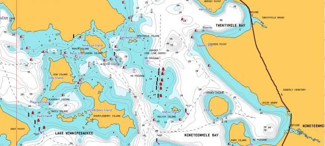
This is centered on the Graveyard. Basically its a path through all those underwater boulders. If it makes you nervous just go around the east side of Melvin Island and miss the whole thing.
http://www.bing.com/maps/?v=2&cp=43....lvl=16&sty=h&q |
|
|
|
| The Following User Says Thank You to jrc For This Useful Post: | ||
cillovely (05-29-2014) | ||
|
05-29-2014, 10:06 AM
|
#40 | |
|
Senior Member

Join Date: Jul 2004
Posts: 2,985
Thanks: 246
Thanked 744 Times in 444 Posts
|
Quote:
|
|
|
|
|
| The Following User Says Thank You to Dave R For This Useful Post: | ||
cillovely (05-29-2014) | ||
|
05-29-2014, 10:48 AM
|
#41 |
|
Senior Member
Join Date: Jun 2010
Location: Boston, MA
Posts: 106
Thanks: 17
Thanked 26 Times in 15 Posts
|
Thank you all. I think I know where you are talking, it's the area on the map that I go "yikes, I'm not going near that". I just never heard it called the Graveyard. Almost rented near there this year, glad I didn't

|
|
|
|
|
05-29-2014, 10:52 AM
|
#42 |
|
Senior Member
Join Date: May 2012
Posts: 156
Thanks: 30
Thanked 40 Times in 25 Posts
|
The Graveyard is pretty well marked and very navigable. Sure you should know where it is, but once you get there it's pretty easy to get through IMO.
If anything my only issue with it is the 'hotdog' captains out there who feel the need to go through it much faster then necessary. It's fairly narrow but can fit two boats, but if one boat is going a lot faster and putting out a good wake it's just not very courteous to others going through at the same time... |
|
|
|
|
05-29-2014, 11:03 AM
|
#43 | |
|
Senior Member
Join Date: Jul 2004
Posts: 2,985
Thanks: 246
Thanked 744 Times in 444 Posts
|
Quote:
Last edited by Dave R; 05-29-2014 at 11:55 AM. |
|
|
|
|
|
05-29-2014, 01:07 PM
|
#44 | |
|
Senior Member
Join Date: Jul 2005
Location: Berlin, Ma / Gilford
Posts: 1,934
Thanks: 450
Thanked 605 Times in 341 Posts
|
Quote:
I was not over there this past week end, however like a lot of the markers this time of Season, I suspect that the buoy you are referring to is/was not in it's proper location -- Your best words to STRIPER that have been echoed many times in here -- DO NOT think for a minute that because someone else did it -- it's right ! .
__________________
A bad day on the Big Lake (although I've never had one) - Still beats a day at the office!! |
|
|
|
|
| The Following User Says Thank You to Phantom For This Useful Post: | ||
znh (05-29-2014) | ||
|
05-29-2014, 01:45 PM
|
#45 | |
|
Senior Member
Join Date: May 2012
Posts: 156
Thanks: 30
Thanked 40 Times in 25 Posts
|
Quote:
Someone else did say the same about a passage there, they said it was on the East side of the island, we were on the West side of it...oh well, I'll never know  On a side note, to echo your quote of "A bad day on the Big Lake (although I've never had one) - Still beats a day at the office!!" We had friends up and even though I crashed the boat we were still all expressing the same sentiment
|
|
|
|
|
|
05-29-2014, 02:28 PM
|
#46 |
|
Senior Member
Join Date: Jul 2008
Location: Ruskin FL
Posts: 1,027
Thanks: 188
Thanked 322 Times in 179 Posts
|
The best advice I know of, when it comes to some of those obviously really tight passages, do a 180 and get out of there. There is plenty of deep water to explore in all areas of the lake. They say that curiosity kills a cat, it also "eats" a lot of props!!
|
|
|
|
|
05-30-2014, 07:34 AM
|
#47 |
|
Senior Member
Join Date: Jul 2005
Location: Berlin, Ma / Gilford
Posts: 1,934
Thanks: 450
Thanked 605 Times in 341 Posts
|
and for the record ......
I did NOT "tag" the Long Island bridge .... I have been using this signature for years .
__________________
A bad day on the Big Lake (although I've never had one) - Still beats a day at the office!! |
|
|
|
|
05-30-2014, 08:44 AM
|
#48 | |
|
Senior Member
Join Date: Jul 2005
Location: Berlin, Ma / Gilford
Posts: 1,934
Thanks: 450
Thanked 605 Times in 341 Posts
|
Quote:
If you were on the Northeast side ... you were doomed & lucky you only came away with a dented prop!! .
__________________
A bad day on the Big Lake (although I've never had one) - Still beats a day at the office!! |
|
|
|
|
|
05-30-2014, 09:23 AM
|
#49 | |
|
Senior Member
Join Date: May 2012
Posts: 156
Thanks: 30
Thanked 40 Times in 25 Posts
|
Quote:
Larger map is to give others the perspective of where this was...yellow circle is 'Welcome Island' with the big blue house on it and the blue X is our boat. The point at the bottom of the map is the tip of Governors. On the smaller map : The orange circles are where the buoys were. The maroon boat was the pontoon boat that we were kind of watching and following, they made it through unscathed. The red boat is us and just about where I hit the rock. I saw a couple others go by right before it and knew they were super shallow and tried to steer around what else I could see but didn't make it. So are you saying we were on the side with the passage ? |
|
|
|
|
|
05-30-2014, 11:09 AM
|
#50 |
|
Senior Member
Join Date: Jul 2005
Location: Berlin, Ma / Gilford
Posts: 1,934
Thanks: 450
Thanked 605 Times in 341 Posts
|
HMMMMmmm
From your great illustration, the solid red (with X) is on the correct side -- the other "went with God aboard" .
__________________
A bad day on the Big Lake (although I've never had one) - Still beats a day at the office!! |
|
|
|
|
05-30-2014, 11:19 AM
|
#51 | |
|
Senior Member
Join Date: May 2012
Posts: 156
Thanks: 30
Thanked 40 Times in 25 Posts
|
Quote:
Maybe someday you can show me the 'local' route
|
|
|
|
|
|
05-30-2014, 11:19 AM
|
#52 |
|
Senior Member
Join Date: Jun 2012
Location: Derry / Gilford
Posts: 1,246
Thanks: 74
Thanked 345 Times in 235 Posts
|
This must have hurt! Looking at your Satelite images, it looks like you missed some deeper water if you were just slightly further west.
I don't have my Bizer map with me, but looking at the Duncan Press map, I may have gone on the west side of Pitchwood Island, closer to Spindle point. Thanks for pointing this area out to me.
__________________
Don't listen to me, obviously I don't understand what I'm talking about! Let's help each other save time and money: WinniGas.com |
|
|
|
|
05-30-2014, 11:29 AM
|
#53 | |
|
Senior Member
Join Date: May 2012
Posts: 156
Thanks: 30
Thanked 40 Times in 25 Posts
|
Quote:
That was the other issue, when quickly looking at the map and the perspective we had from our approach into here I thought I was West of Pitchwood...then as I got closer into the channel I figured out I was wrong... It will be hurting the wallet shortly...the Break Out Another Thousand is spot on here
|
|
|
|
|
|
05-30-2014, 11:38 AM
|
#54 |
|
Junior Member
Join Date: Apr 2004
Posts: 11
Thanks: 0
Thanked 2 Times in 1 Post
|
|
|
|
|
|
05-30-2014, 11:39 AM
|
#55 |
|
Senior Member
Join Date: Apr 2004
Location: NH
Posts: 2,689
Thanks: 33
Thanked 439 Times in 249 Posts
|
Unless you live in there, why would you need to go in there? I've kayaked through there, it's a rock garden. Sure it may be possible to make it through but why?
BTW I've found a shortcut through the Witches with my kayak, do you want to try that too? No offense intended just having a little fun. |
|
|
|
|
05-30-2014, 11:41 AM
|
#56 |
|
Senior Member
Join Date: May 2012
Posts: 156
Thanks: 30
Thanked 40 Times in 25 Posts
|
Mostly I thought I was somewhere else, was not purposely trying to go through there as I agree there is no reason to, once I realized where I actually was it was too late...
I would love a guided tour through the Witches... in my kayak
|
|
|
|
|
05-30-2014, 11:53 AM
|
#57 | |
|
Senior Member
Join Date: Jul 2005
Location: Berlin, Ma / Gilford
Posts: 1,934
Thanks: 450
Thanked 605 Times in 341 Posts
|
Quote:
By the Way -- ever powerboat between Big & Little Islands in Paugus Bay ? That is one I learnt years ago and always makes others STOP and look (waiting for ya hit). .
__________________
A bad day on the Big Lake (although I've never had one) - Still beats a day at the office!! |
|
|
|
|
|
06-05-2014, 09:21 AM
|
#58 | |
|
Senior Member

Join Date: Feb 2003
Location: MA
Posts: 914
Thanks: 602
Thanked 193 Times in 91 Posts
|
Quote:
|
|
|
|
|
|
06-05-2014, 09:30 AM
|
#59 |
|
Senior Member
Join Date: Apr 2004
Location: NH
Posts: 2,689
Thanks: 33
Thanked 439 Times in 249 Posts
|
I usually kayak the Witches every weekend, either Saturday or Sunday morning, sometimes both. Anyone wants to come along, PM me and we can meet near Glendale.
|
|
|
|
|
06-05-2014, 09:44 AM
|
#60 |
|
Senior Member
Join Date: Apr 2004
Location: NH
Posts: 2,689
Thanks: 33
Thanked 439 Times in 249 Posts
|
Phantom, In a pinch I would power boat through there... in your boat
There are really four underwater rock piles, separated by relatively open water. I have absolutely no need to bring a power boat in there, so I wouldn't. I do see fishermen in there from time to time. I would like to kayak around Big and Little, I know you can boat between them but never have. Again it's too easy to go around. |
|
|
|
|
06-05-2014, 09:56 AM
|
#61 |
|
Senior Member
Join Date: Jul 2005
Location: Berlin, Ma / Gilford
Posts: 1,934
Thanks: 450
Thanked 605 Times in 341 Posts
|
I agree on it's too easy to go around, which I do 99.9% of the time.
Point was to "newbies" -- NEVER EVER follow someone ! Use your own head & chart ! The driver you watched may have no more idea of where he is going than you or has extremely good "local" knowledge. Do you want to risk your boat and passengers to find out which ? .
__________________
A bad day on the Big Lake (although I've never had one) - Still beats a day at the office!! |
|
|
|
|
06-05-2014, 10:03 AM
|
#62 | |
|
Senior Member
Join Date: Jul 2004
Posts: 2,985
Thanks: 246
Thanked 744 Times in 444 Posts
|
Quote:
I shot this video over the weekend in Argentina. This is typical boat handling here. Very entertaining and such a stark contrast to the NH safe passage concept... https://www.youtube.com/watch?v=fyb5...ature=youtu.be |
|
|
|
|
| The Following User Says Thank You to Dave R For This Useful Post: | ||
znh (06-06-2014) | ||
|
06-05-2014, 08:22 PM
|
#63 | |
|
Senior Member
Join Date: Aug 2002
Location: Gilford, NH
Posts: 638
Thanks: 499
Thanked 194 Times in 101 Posts
|
Quote:
I hate to leave the topic of the this thread but what is that house or whatever at the very end of your video? |
|
|
|
|
|
06-05-2014, 08:27 PM
|
#64 | |
|
Senior Member
Join Date: Jul 2004
Posts: 2,985
Thanks: 246
Thanked 744 Times in 444 Posts
|
Quote:
It's a former president's summer place. It's in glass to preserve it. That's what I was video taping, but the tour boat was more interesting to me. |
|
|
|
|
|
06-06-2014, 10:10 AM
|
#65 | |
|
Senior Member
Join Date: May 2006
Posts: 283
Thanks: 1
Thanked 66 Times in 38 Posts
|
Quote:
|
|
|
|
|
| The Following User Says Thank You to 4Fun For This Useful Post: | ||
Striper295 (06-08-2014) | ||
|
06-06-2014, 12:19 PM
|
#66 |
|
Senior Member
Join Date: May 2013
Location: Gilmanton, NH
Posts: 139
Thanks: 37
Thanked 23 Times in 20 Posts
|
A GPS like a Garmin is very useful especially if you plan on entertaining guests frequently. At that point it's not just your own life in your hands. Garmin does a great job of canvassing the lake and making continuous improvements to their software. It isn't all-encompassing--having the Bizer map is a great idea as well just to help you keep your bearings and navigate tricky areas.
We were going through what we learned later was the graveyard--planing out at mid-20s cutting a corner of it off accidentally. I was on the front of the boat and started yelling at my friend because I could see boulders right below the surface! We really, really, really lucked out and didn't hit anything whatsoever...But we paid a LOT more attention to all the buoys after that day. That said, there are a lot of large, uninterrupted areas to cut your teeth on before you start to navigate the trickier areas. I'm a big fan of Sally's Gut and Stonedam Island.
__________________
>>>Matt<<< To Tow: 2007 Honda Ridgeline RTL To Float: 1977 MFG Gypsy Star 17 O/B |
|
|
|
|
06-08-2014, 09:35 AM
|
#67 | |
|
Member
Join Date: May 2014
Posts: 34
Thanks: 36
Thanked 2 Times in 2 Posts
|
Quote:

|
|
|
|
|
|
06-08-2014, 02:17 PM
|
#68 |
|
Member
Join Date: Apr 2004
Posts: 33
Thanks: 1
Thanked 444 Times in 32 Posts
|
The following is the technique Marine Patrol has used for years. We do use electronics, but they aren't 100% reliable and officers still need to navigate when they are not available. Investing time studying the chart before heading out is very valuable.
The technique that we have found that seems to work best includes several different tasks. 1. Get a chart! Get a compass that you can read at a glance. 2. Memorize the number and location of every navigation light on the lake...forces you to have an image of the lake in your mind and impresses any Winni boater at trivia time! (Where is light #34? Name all the lights that have a double flash!) 3.Always have the chart in front of you while underway. Orient the chart so that the area of the lake your travelling to is at the top of the page. This will require you to constantly "manage" the position of your chart but allows you to anticipate the next buoy, light, island, cove, etc. For this reason I prefer a water proof chart that is not laminated, it allows you to bend/fold it to the size and angle that works best for you. Once you master the lake, the laminated ones are great. You'll want to retire the old one because it will be worn out! 4. While navigating, look for... and find the next reference point that you should encounter according to the chart. If you can't find it, STOP! This should prevent you from getting into trouble. Once you confirm your location, continue. If you still can't locate your precise location...now use your GPS, or return to your last known point. 5. GPS are tremendous tools, but I find the use of GPS and RADAR for beginners doesn't give the person the "back of your hand" knowledge that those who truly know lake navigation desire. Use it to keep yourself out of trouble, bad weather, and darkness. 6. Finally, once your are comfortable with getting around the lake without your chart because you know each buoy/light/hazard, trim up that hardware and explore. What is behind that buoy? How do you pass through that channel? Purchase a boat hook, measure to the bottom of your prop, and mark the handle with the measurement. Give yourself an extra 6 inches for wave action, and measure if you find yourself in shallow water. Shut down and paddle/push out if in trouble. Nothing substitutes for time at the helm. Don't follow other boaters and don't get caught on the lake after dark. Any Winni navigator will tell you it is a much different lake after dark! Safe Boating!! |
|
|
|
| The Following 20 Users Say Thank You to Marine Patrol For This Useful Post: | ||
ApS (06-08-2014), Dad sold the C * C (06-08-2014), Dave R (06-08-2014), Descant (06-08-2014), Happy Gourmand (06-09-2014), Just Sold (06-10-2014), kauriel (06-09-2018), Lakewinn1 (06-14-2014), mhtranger (06-08-2014), NHskier (06-08-2014), pcmc (06-14-2014), pjard (06-08-2014), Slickcraft (06-08-2014), soupyjr8 (06-13-2014), Striper295 (06-13-2014), upthesaukee (06-08-2014), WakeboardMom (06-08-2014), Winni P (06-15-2014), Winnisquamguy (06-14-2014), znh (06-09-2014) | ||
|
06-09-2014, 07:58 PM
|
#69 | |
|
Junior Member
Join Date: Sep 2012
Posts: 6
Thanks: 9
Thanked 1 Time in 1 Post
|
Quote:
|
|
|
|
|
| The Following User Says Thank You to thekings For This Useful Post: | ||
Striper295 (06-13-2014) | ||
|
06-13-2014, 05:09 PM
|
#70 | |
|
Member
Join Date: May 2014
Posts: 34
Thanks: 36
Thanked 2 Times in 2 Posts
|
Quote:
|
|
|
|
|
|
06-14-2014, 01:32 PM
|
#71 |
|
Senior Member

Join Date: Feb 2004
Location: Center Harbor
Posts: 1,174
Thanks: 207
Thanked 437 Times in 253 Posts
|
I remember the color and compass direction combinations by putting them all in alphabetical order
Black East North Red South West However, I find the dashed navigation lines on the maps more useful. Also, I mostly avoid tight/confusing navigation areas because I don't want to risk having to replace 2 stainless steel props for over $600 (or worse). If I want to explore I putt around on my jet ski. Also before you go between a red and black marker, make sure they are SOLID color. A neighbor lost his lower unit over that mistake. Ouch. Again, dashed nav lines are helpful at avoiding this problem. |
|
|
|
| The Following 2 Users Say Thank You to jeffk For This Useful Post: | ||
pcmc (06-14-2014), Striper295 (06-16-2014) | ||
|
06-15-2014, 10:52 AM
|
#72 |
|
Senior Member
Join Date: Sep 2009
Posts: 50
Thanks: 3
Thanked 13 Times in 10 Posts
|
I think "nor'easters"are black and the "south west" is hot (red). Simple, except when you change direction and don't notice!
|
|
|
|
|
06-16-2014, 05:58 AM
|
#73 |
|
Senior Member
Join Date: Apr 2006
Location: Alton, NH
Posts: 722
Thanks: 337
Thanked 280 Times in 123 Posts
|
Keeping a log of your time on the water as to your planned voyage and encounters and observations, weather and traffic, bouy lacations ect... can be very helpful and something to re-read and contemplate later for planning another trip. After all, before electronics that is all there was and it still a valuable tool whether in writing or on a tablet.
__________________
Waking up in the morning is the greatest, everything after that is a bonus
|
|
|
|
| The Following User Says Thank You to riverat For This Useful Post: | ||
Striper295 (06-16-2014) | ||
|
06-16-2014, 08:32 AM
|
#74 |
|
Senior Member
Join Date: Jun 2007
Posts: 298
Thanks: 14
Thanked 147 Times in 62 Posts
|
When not sure, simply ask Ben (Black East North).
|
|
|
|
| The Following User Says Thank You to NH_boater For This Useful Post: | ||
Striper295 (06-16-2014) | ||
|
06-16-2014, 09:15 AM
|
#75 | |
|
Senior Member
Join Date: Jul 2004
Posts: 2,985
Thanks: 246
Thanked 744 Times in 444 Posts
|
Quote:
|
|
|
|
|
|
01-25-2016, 12:21 AM
|
#76 | |
|
Member
Join Date: Sep 2015
Location: NH
Posts: 39
Thanks: 4
Thanked 12 Times in 7 Posts
|
Quote:
Bizer and Duncan should have that on every map they print, and pay you a royalty! |
|
|
|
|
|
| Bookmarks |
|
|


 Linear Mode

