

|
|
|
|
|
|||||||
| Home | Forums | Gallery | Webcams | Blogs | YouTube Channel | Classifieds | Register | FAQ | Donate | Members List | Today's Posts | Search |
 |
|
|
Thread Tools | Display Modes |
|
|
 08-23-2015, 08:42 PM
|
#1 |
|
Senior Member
Join Date: Sep 2009
Location: Moultonborough, NH
Posts: 1,515
Thanks: 394
Thanked 527 Times in 269 Posts
|
I think most marina's on the lake like the markers just the way they are. Their service departments are always busy.
|

|

|
| The Following 2 Users Say Thank You to Greene's Basin Girl For This Useful Post: | ||
Dave R (08-24-2015), Smith Point (08-25-2015) | ||
|
08-24-2015, 09:58 AM
|
#2 |
|
Senior Member

Join Date: Jul 2004
Posts: 2,985
Thanks: 246
Thanked 744 Times in 444 Posts
|
I am perfectly capable of dealing with Winni ATONs but, I would love to see NH adopt a better marking system.
The witches (and other similar hazards that are not near shore) could be easily surrounded by standard hazard markers that would be far easier to see. Bright orange on white is much more visible than red over white or black over white, and the current marker diameter is too small. Standard underwater hazard markers: 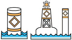 Hazards near shore could be marked with these:  Which everyone (that boats outside of NH...) knows means don't pass between marker and shore. Channels like the 6 pack and Graveyard should stay marked as-is, but I would live to see the number of marked channels expanded to include areas like north and west of Dow Island. The spars there practically mark a channel now, why not just make it official so there's no possibility of thinking the proper thing to do is go around the markers rather than through them? |
|
|
|
| The Following 6 Users Say Thank You to Dave R For This Useful Post: | ||
Greene's Basin Girl (08-24-2015), mhtranger (08-24-2015), noreast (08-24-2015), Resident 2B (08-24-2015), Smith Point (08-24-2015), trfour (08-24-2015) | ||
|
08-24-2015, 04:12 PM
|
#3 |
|
Senior Member
Join Date: Mar 2006
Location: Merrimack and Welch Island
Posts: 4,413
Thanks: 1,365
Thanked 1,636 Times in 1,068 Posts
|
There really aren't many new ideas here.
I hesitate to guess the dates, but I'd say in the late 60's, for several years, the Witches were ringed with (6? 8?) orange barrels, probably old beer kegs to be consistent with the state budget. These floated on their sides, very high in the water, and had a white reflective stripe, probably 6" wide. Very easy to see, day or night. Good for radar, but nobody had radar in those days. I don't know why they were removed and not replaced, but I bet they didn't reduce the number of service calls enough to justify the cost of removing replacing seasonally. I believe it was shortly after that when flasher #71 was added. I sometimes think the extra flasher adds to light confusion. When there was only #28, and you saw a flasher, you knew which one you were looking at. Of course, if you can read the chart at night, you'll see that #71 has a double flash. Nevertheless, it seems most of the discussion here is about daytime navigation. If you can find Governor's Island, Lockes Island, and Timber Island, it should be simple stuff to find and avoid the Witches, or to go to the deep water closer to Governor's and Lockes. The Mount goes through there occasionally. You should have no problem. |
|
|
|
|
08-24-2015, 07:39 PM
|
#4 | |
|
Senior Member

Join Date: Jul 2002
Location: Massachusetts
Posts: 336
Thanks: 0
Thanked 243 Times in 82 Posts
|
Quote:
|
|
|
|
|
|
08-24-2015, 09:45 PM
|
#5 |
|
Senior Member

Join Date: Jan 2012
Posts: 2,115
Thanks: 64
Thanked 749 Times in 483 Posts
|
Most of my boating has been in salt water.
I realize that the markings on inland waters may have a different scheme but my opinion at first observation was that they are inadequate. My opinion hasn't changed after thirteen years of Winni boating. As much as some may desire it to be, this is not a place where everybody comes equipped with charts, experience reading them and Chapman's Piloting committed to memory. Better marking is needed. |
|
|
|
| The Following User Says Thank You to 8gv For This Useful Post: | ||
Smith Point (08-25-2015) | ||
| Sponsored Links |
|
|
|
| Bookmarks |
|
|


 Hybrid Mode
