

|
|
|
|
|
|||||||
| Home | Forums | Gallery | Webcams | Blogs | YouTube Channel | Classifieds | Register | FAQ | Members List | Donate | Today's Posts | Search |
 |
|
|
Thread Tools | Display Modes |
 08-22-2016, 12:30 PM
|
#1 |
|
Senior Member

Join Date: Aug 2013
Location: Bedford, NH; Meredith, NH
Posts: 979
Thanks: 263
Thanked 823 Times in 340 Posts
|
As a customer of Watermark, I am on their email distribution list. They sent out a blast last week advising folks to be very careful due to the low water levels, and stated that Winnipesaukee is 11" below full lake.
As I was going through Sally's Gut on Saturday morning, Watermark's email suddenly came to mind. Man, is it low! I put the outdrive almost all the way up just to be safe. I've been going through there for years and don't recall ever seeing the hazards in there so up close and personal. It is also getting very shallow at our dock. We normally keep the boat in till mid to late October, but I am seriously considering pulling the plug on the boating season right after Labor Day. What are others seeing? |

|

|
|
08-22-2016, 04:05 PM
|
#2 |
|
Senior Member
Join Date: Mar 2006
Location: Merrimack and Welch Island
Posts: 4,476
Thanks: 1,387
Thanked 1,667 Times in 1,086 Posts
|
Water is low, but not much different than what I expect in October. I'm planning on five weekdays of rain three times in September. We need to recharge the watershed before rain will impact lake levels very much.
|
|
|
|
|
08-23-2016, 12:37 PM
|
#3 | |
|
Senior Member
Join Date: Sep 2009
Location: Moultonborough, NH
Posts: 1,515
Thanks: 394
Thanked 527 Times in 269 Posts
|
Quote:
|
|
|
|
|
|
08-23-2016, 02:10 PM
|
#4 |
|
Senior Member

Join Date: May 2006
Location: Texas, Lake Ray Hubbard and NH, Long Island Winnipesaukee
Posts: 2,923
Thanks: 1,053
Thanked 901 Times in 531 Posts
|
In reality we are not that much lower then normal only a few inches.... My wife and I discussed that the level we saw this weekend, is typically what we see mid September.
What we need is some good steady rain, and the lake will respond... we got the first dose of that Sunday night... Hopefully another good storm will come through in the next couple of week.... I was nervous in Sally's gut two weeks ago.... not sure I would bother going through now.... I will be watching the water level closely... and am prepared to go yank the boat when I stop feeling comfortable with it in... In the past I have let the lake get down to 503.10...but me comfort level is about 503.20 at my dock.... so we might not be boating this labor day.....
__________________
Life is about how much time you can spend relaxing... I do it on an island that isn't really an island..... |
|
|
|
|
08-23-2016, 03:00 PM
|
#5 |
|
Senior Member
Join Date: May 2012
Posts: 156
Thanks: 30
Thanked 40 Times in 25 Posts
|
Exiting our marina is getting very, very low. 16-18 inches low. At least it's really soft sand and nothing else but someone said a boat got stuck the other day. I wonder if we could dig it deeper

|
|
|
|
| Sponsored Links |
|
|
|
08-23-2016, 05:48 PM
|
#6 | |
|
Senior Member
Join Date: Mar 2006
Location: Merrimack and Welch Island
Posts: 4,476
Thanks: 1,387
Thanked 1,667 Times in 1,086 Posts
|
Quote:
|
|
|
|
|
|
08-23-2016, 07:10 PM
|
#7 |
|
Senior Member
Join Date: May 2012
Location: Litchfield/Gilford
Posts: 828
Thanks: 233
Thanked 224 Times in 131 Posts
|
|
|
|
|
|
08-24-2016, 07:12 AM
|
#8 | |
|
Senior Member

Join Date: Jul 2005
Location: Berlin, Ma / Gilford
Posts: 1,934
Thanks: 450
Thanked 605 Times in 341 Posts
|
Quote:
The entrance channel is constantly "choked" due to shifting sand from their vast beach area as well as nearby Ellacoya State Park .
__________________
A bad day on the Big Lake (although I've never had one) - Still beats a day at the office!! |
|
|
|
|
|
08-24-2016, 11:05 AM
|
#9 |
|
Senior Member

Join Date: Oct 2006
Location: Valencia, Spain (formerly Rattlesnake Isle)
Posts: 389
Thanks: 135
Thanked 142 Times in 82 Posts
|
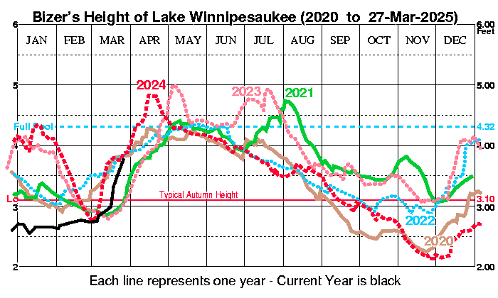
Based on the chart, we're currently tied for the third lowest level for this time of year (over the last 16 years). I'd say that's pretty abnormal.
|
|
|
|
|
08-24-2016, 11:18 AM
|
#10 | |
|
Senior Member
Join Date: May 2012
Posts: 156
Thanks: 30
Thanked 40 Times in 25 Posts
|
Quote:
Can the State stop the flow out of the dam at all to let the lake come up? Has this ever happened? |
|
|
|
|
|
08-24-2016, 12:15 PM
|
#11 |
|
Senior Member
Join Date: Apr 2004
Posts: 505
Thanks: 12
Thanked 428 Times in 147 Posts
|
The outflow volume of Winnipesaukee cannot be reduced below a certain minimum level. There needs to be enough flow in the rivers downstream to provide aquatic habitat, address downstream owners water rights, and to accommodate outflows from wastewater treatment facilities.
|
|
|
|
| The Following 3 Users Say Thank You to Onshore For This Useful Post: | ||
|
08-26-2016, 12:33 PM
|
#12 |
|
Senior Member
Join Date: Mar 2012
Posts: 122
Thanks: 86
Thanked 46 Times in 27 Posts
|
According to the NHDES watershed operations website, the lake level at the Lakeport Dam was at El. 503.23, only 0.13 feet (1 1/2") above typical autumn levels as of 5am this morning (8-26-2016). I think I may have to lower the dock a bit for the rest of the season, if the weather doesn't change soon.

|
|
|
|
|
08-26-2016, 12:59 PM
|
#13 |
|
Senior Member
Join Date: May 2005
Posts: 495
Thanks: 5
Thanked 169 Times in 87 Posts
|
So I just heard that the Sophie C ran aground somewhere near Loon island but I cannot confirm this. Has anyone heard anything?
|
|
|
|
|
08-26-2016, 01:43 PM
|
#14 | |
|
Senior Member

Join Date: Apr 2004
Posts: 5,075
Thanks: 215
Thanked 903 Times in 509 Posts
|
Quote:
__________________
SIKSUKR |
|
|
|
|
|
08-26-2016, 02:03 PM
|
#15 | |
|
Senior Member
Join Date: Mar 2006
Location: Merrimack and Welch Island
Posts: 4,476
Thanks: 1,387
Thanked 1,667 Times in 1,086 Posts
|
Quote:
From a purely selfish point of view, I'd like to see full lake on August 1st instead of sometime in the spring. That hopefully would mean we get a full boating season through Columbus Day. I spoke to the state dam manager about this years ago. At the time, the DES concept was that boating ended on Labor Day. They have been doing a much better job of keeping us going in the fall over the last several years, but sometimes there aren't many choices. |
|
|
|
|
|
08-26-2016, 02:57 PM
|
#16 |
|
Senior Member
Join Date: Jan 2003
Location: Alton Bay
Posts: 5,614
Blog Entries: 2
Thanks: 2,483
Thanked 1,987 Times in 1,087 Posts
|
If we look at the normal rainfall vs the actual, the DES website shows we are +/- 6 inches YTD on rainfall, which would put us some inches higher lake level than we are now. In my mind, not a mismanagement of outflow, but a result of nature.
I live here... I am always Upthesaukee.
__________________
I Live Here... I am always UPTHESAUKEE !!!! |
|
|
|
|
08-26-2016, 03:10 PM
|
#17 |
|
Senior Member

Join Date: Aug 2010
Location: Tuftonborough & Franklin MA
Posts: 265
Thanks: 99
Thanked 143 Times in 64 Posts
|
In the silver lining department, I'm noticing better water clarity and significantly less "rock snot" this year especially considering that it's been a pretty hot summer. I'm assuming this is due in part to less run off from the surrounding areas from the lack of rain. I hope we get some significant rain soon though, it's getting pretty skinny where we dock on the mainland.
__________________
" Any day with a boat ride in it is a good day" |
|
|
|
|
08-27-2016, 06:50 AM
|
#18 |
|
Senior Member
Join Date: Aug 2002
Location: Gilford, NH
Posts: 645
Thanks: 514
Thanked 195 Times in 102 Posts
|
Very little if any rain in the 10 day....oh boy! My boat doesn't draft much but we like to boat all the way until November. Maybe a little hairy to try that this year. C'mon rain!
|
|
|
|
|
08-31-2016, 09:23 AM
|
#19 |
|
Senior Member
Join Date: Mar 2012
Posts: 122
Thanks: 86
Thanked 46 Times in 27 Posts
|
As an update for all those interested the lake level is now at 503.18 as of yesterday (8-30-16) morning at 5am. This puts us exactly 1-inch above the normal autumn level. We could certainly use a tropical system of some kind to raise the level back up.
|
|
|
|
|
08-31-2016, 09:56 AM
|
#20 |
|
Senior Member

Join Date: Jan 2012
Posts: 2,127
Thanks: 64
Thanked 753 Times in 487 Posts
|
Be careful doing the rain dance.
At the moment I am in Tierra Verde FL. We had four inches of rain last night and can expect another two today. |
|
|
|
| The Following User Says Thank You to 8gv For This Useful Post: | ||
KPW (08-31-2016) | ||
|
08-31-2016, 10:07 AM
|
#21 |
|
Senior Member
Join Date: Jun 2012
Location: Derry / Gilford
Posts: 1,247
Thanks: 74
Thanked 346 Times in 236 Posts
|
Bring some baggies of it back with you and dump it in the lake please!

__________________
Don't listen to me, obviously I don't understand what I'm talking about! Let's help each other save time and money: WinniGas.com |
|
|
|
|
08-31-2016, 03:03 PM
|
#22 | |
|
Senior Member

Join Date: Nov 2002
Location: The Lakes, Central NH. and Dallas/Fort Worth TX.
Posts: 3,694
Blog Entries: 3
Thanks: 3,069
Thanked 472 Times in 236 Posts
|
Quote:
__________________
trfour Always Remember, The Best Safety Device In The Boat, or on a PWC Snowmobile etc., Is YOU! Safe sledding tips and much more; http://www.snowmobile.org/snowmobiling-safety.html |
|
|
|
|
|
08-31-2016, 03:06 PM
|
#23 |
|
Senior Member
Join Date: Apr 2004
Posts: 5,075
Thanks: 215
Thanked 903 Times in 509 Posts
|
Yup, need a hurricane. Well maybe a tropical storm. Well maybe a good tropical wave. there is a chance on Mondayish.
__________________
SIKSUKR |
|
|
|
|
09-02-2016, 06:42 AM
|
#24 |
|
Senior Member
Join Date: Apr 2004
Location: Suncook, NH, but at The Lake at Heart
Posts: 2,615
Thanks: 1,083
Thanked 434 Times in 210 Posts
|
Has anyone launched at Downings Landing in Alton Bay Lately? Wondering if the ramp is still useable for this weekend.
__________________
Just Sold  At the lake the stress of daily life just melts away. Pro Re Nata |
|
|
|
|
09-02-2016, 07:15 AM
|
#25 | |
|
Senior Member

Join Date: Jul 2004
Posts: 2,985
Thanks: 246
Thanked 744 Times in 444 Posts
|
Quote:
|
|
|
|
|
| The Following User Says Thank You to Dave R For This Useful Post: | ||
Just Sold (09-02-2016) | ||
|
09-02-2016, 05:45 PM
|
#26 | |
|
Senior Member
Join Date: Apr 2016
Location: In the hills
Posts: 2,420
Thanks: 1,677
Thanked 786 Times in 466 Posts
|
Quote:
|
|
|
|
|
|
09-04-2016, 09:38 PM
|
#27 | |
|
Junior Member
Join Date: Jun 2015
Location: Seacoast NH
Posts: 11
Thanks: 6
Thanked 1 Time in 1 Post
|
Quote:
Was a full house there this am. Had to head to wolfeboro to get in today. Sent from my iPhone using Tapatalk |
|
|
|
|
|
09-06-2016, 09:03 AM
|
#28 |
|
Senior Member
Join Date: Aug 2013
Location: Bedford, NH; Meredith, NH
Posts: 979
Thanks: 263
Thanked 823 Times in 340 Posts
|
.....boat starting hitting the bottom at our dock on Sunday. Unbelievable! Fortunately, it's all sand, so no issues, and it is now on the mooring, (where I probably should have put it a week ago ). No appreciable rain in sight, either

|
|
|
|
| The Following User Says Thank You to MeredithMan For This Useful Post: | ||
Hillcountry (09-06-2016) | ||
|
09-13-2016, 08:21 AM
|
#29 |
|
Senior Member
Join Date: Mar 2012
Posts: 122
Thanks: 86
Thanked 46 Times in 27 Posts
|
As an update for all, the current lake level as of Monday September 12th, 2016 is 502.88 at the Lakeport Dam. This puts us at 1.44 feet or 17 1/2" below full pool and almost 4" below normal autumn levels.
|
|
|
|
|
09-13-2016, 08:58 AM
|
#30 | |
|
Senior Member
Join Date: Feb 2008
Location: Gilford, NH / Welch Island
Posts: 6,367
Thanks: 2,422
Thanked 5,349 Times in 2,093 Posts
|
Quote:
Dan
__________________
It's Always Sunny On Welch Island!!
|
|
|
|
|
|
09-13-2016, 01:02 PM
|
#31 | |
|
Senior Member

Join Date: Apr 2004
Location: Bear Island
Posts: 1,765
Thanks: 32
Thanked 441 Times in 207 Posts
|
Quote:
|
|
|
|
|
| The Following User Says Thank You to Bear Islander For This Useful Post: | ||
WoNHUSA (09-18-2016) | ||
|
09-13-2016, 02:17 PM
|
#32 |
|
Senior Member

Join Date: Aug 2008
Location: Beverly Cove, Ma
Posts: 359
Thanks: 288
Thanked 148 Times in 82 Posts
|
We were up and out for several hours yesterday. It may have been one of our best boating days of the summer. We didn't want to come back! Minge Cove was very low, even lower than when we were there one week ago. Even trimmed up, I still hit mud in several spots. There was talk at the marina that it was possible the level may be dropped another 6 inches although I've read here in other comments that they probably wouldn't at this time. That would be the end for me as well as many other boaters, I'm sure.
__________________
I'd rather be relax'n at Winnipesaukee |
|
|
|
|
09-13-2016, 04:09 PM
|
#33 | |
|
Senior Member
Join Date: May 2006
Location: Texas, Lake Ray Hubbard and NH, Long Island Winnipesaukee
Posts: 2,923
Thanks: 1,053
Thanked 901 Times in 531 Posts
|
Quote:
__________________
Life is about how much time you can spend relaxing... I do it on an island that isn't really an island..... |
|
|
|
|
|
09-13-2016, 04:32 PM
|
#34 | |
|
Senior Member
Join Date: Jul 2005
Location: Berlin, Ma / Gilford
Posts: 1,934
Thanks: 450
Thanked 605 Times in 341 Posts
|
Quote:
Normally it's a Rapids under the bridge, now simply boulders with very little tranquil water passing. .
__________________
A bad day on the Big Lake (although I've never had one) - Still beats a day at the office!! |
|
|
|
|
|
09-13-2016, 04:52 PM
|
#35 |
|
Senior Member
Join Date: Apr 2004
Location: Meredith (Winnisquam) & Nashua, NH
Posts: 216
Thanks: 25
Thanked 20 Times in 17 Posts
|
I believe this is the year, usually even years, that Winnisquam and bodies of water further downstream get extra low for a 2 week period around Columbus Day as well.
|
|
|
|
|
09-14-2016, 06:52 AM
|
#36 |
|
Senior Member

Join Date: Apr 2004
Location: Eastern MA & Frye Island/Sebago Lake, Maine
Posts: 955
Thanks: 256
Thanked 351 Times in 158 Posts
|
Just to give you a perspective, Sebago Lake is 40 inches (3.3') below "full pond" as of this morning. We are approaching peak "Prop and Outdrive" season......
BT
__________________
" Live for today because yesterday is gone and tomorrow may never come" |
|
|
|
| The Following User Says Thank You to Blue Thunder For This Useful Post: | ||
CaptT820 (09-14-2016) | ||
|
09-14-2016, 11:22 AM
|
#37 |
|
Senior Member
Join Date: Sep 2009
Location: Moultonborough, NH
Posts: 1,515
Thanks: 394
Thanked 527 Times in 269 Posts
|
A friend of mine told me that six boats have hit rocks when going through the Graveyard. Apparently the markers have shifted. I am glad that we always avoid the Graveyard by going around the island next to it.
|
|
|
|
| The Following User Says Thank You to Greene's Basin Girl For This Useful Post: | ||
fanfig77200 (09-17-2016) | ||
|
09-14-2016, 12:29 PM
|
#38 |
|
Senior Member
Join Date: Jan 2012
Posts: 2,127
Thanks: 64
Thanked 753 Times in 487 Posts
|
Where is the "Graveyard"? Is there a charted bouy for reference?
|
|
|
|
|
09-14-2016, 12:35 PM
|
#39 |
|
Senior Member
Join Date: Feb 2012
Location: Tuftonboro
Posts: 1,254
Thanks: 193
Thanked 335 Times in 243 Posts
|
Tuftonboro just north of Chases Point and south of Melvin Bay.
|
|
|
|
|
09-14-2016, 01:21 PM
|
#40 | |
|
Senior Member
Join Date: Jun 2012
Location: Derry / Gilford
Posts: 1,247
Thanks: 74
Thanked 346 Times in 236 Posts
|
Quote:
https://webapp.navionics.com/?lang=e...key=ahmiGbcerL
__________________
Don't listen to me, obviously I don't understand what I'm talking about! Let's help each other save time and money: WinniGas.com |
|
|
|
|
|
09-14-2016, 02:27 PM
|
#41 |
|
Senior Member

Join Date: Jul 2014
Posts: 6,434
Thanks: 1,182
Thanked 2,138 Times in 1,325 Posts
|
My GPS has been reliable in terms of safe passage, but I've always wondered what their 'safe threshold' was when marking their suggested routes. For example, I've read that the Graveyard rocks are towards the red buoy, which would be about ten feet from the suggested route on my GPS (which goes right through the middle). I wonder how low the lake would have to be to have an issue...
Sent from my XT1528 using Tapatalk |
|
|
|
|
09-14-2016, 02:47 PM
|
#42 |
|
Senior Member
Join Date: Jul 2005
Location: Berlin, Ma / Gilford
Posts: 1,934
Thanks: 450
Thanked 605 Times in 341 Posts
|
just remember, unless you have a military grade GPS (which no one can) there is a deliberate +/- tolerance to the accuracy of ALL commercially available GPS's.
Use to be 10 meters (33 ft), but I think it has since been tightened up .
__________________
A bad day on the Big Lake (although I've never had one) - Still beats a day at the office!! |
|
|
|
|
09-14-2016, 03:06 PM
|
#43 |
|
Senior Member
Join Date: Jul 2014
Posts: 6,434
Thanks: 1,182
Thanked 2,138 Times in 1,325 Posts
|
Yup, 'swhy I err on the side of caution, but I'm still interested!
Sent from my XT1528 using Tapatalk |
|
|
|
|
09-14-2016, 03:38 PM
|
#44 | |
|
Senior Member
Join Date: Mar 2008
Location: Welch Island and The Taylor Community
Posts: 3,343
Thanks: 1,249
Thanked 2,121 Times in 970 Posts
|
Quote:
http://www.gps.gov/systems/gps/modernization/sa/ |
|

|
|
| The Following User Says Thank You to Slickcraft For This Useful Post: | ||
Phantom (09-15-2016) | ||
|
09-14-2016, 03:47 PM
|
#45 | |
|
Senior Member
Join Date: Feb 2008
Location: Gilford, NH / Welch Island
Posts: 6,367
Thanks: 2,422
Thanked 5,349 Times in 2,093 Posts
|
Quote:
Dan
__________________
It's Always Sunny On Welch Island!!
|
|
|
|
|
|
09-14-2016, 03:55 PM
|
#46 | ||
|
Senior Member
Join Date: Jun 2012
Location: Derry / Gilford
Posts: 1,247
Thanks: 74
Thanked 346 Times in 236 Posts
|
GPS system specs and actual reality seen by end users can be two different things.
I'd suggest that you check with your GPS receiver vendor to see what they say. As an example, many people have a Garmin GPS receiver, here is how they answer the 'how accurate is my GPS' question: Quote:
Quote:
__________________
Don't listen to me, obviously I don't understand what I'm talking about! Let's help each other save time and money: WinniGas.com |
||
|
|
|
|
09-14-2016, 04:11 PM
|
#47 | |
|
Senior Member
Join Date: Mar 2008
Location: Welch Island and The Taylor Community
Posts: 3,343
Thanks: 1,249
Thanked 2,121 Times in 970 Posts
|
Quote:
Yes you should enable WAAS on your GPS. A fixed ground site in the general geographic area with known coordinates receives the GPS signal and calculates instantaneous errors. Correction data is then broadcast which your GPS unit uses to improve accuracy. This will add a small amount of time for your GPS to sync. Not all GPS units have WAAS enabled by default. |
|
|
|
|
|
09-14-2016, 07:05 PM
|
#48 | |
|
Senior Member
Join Date: Sep 2009
Location: Moultonborough, NH
Posts: 1,515
Thanks: 394
Thanked 527 Times in 269 Posts
|
Quote:
|
|
|
|
|
|
09-14-2016, 07:17 PM
|
#49 | |
|
Senior Member
Join Date: Jul 2014
Posts: 6,434
Thanks: 1,182
Thanked 2,138 Times in 1,325 Posts
|
Quote:
Sent from my XT1528 using Tapatalk |
|
|
|
|
|
09-14-2016, 07:45 PM
|
#50 |
|
Senior Member
Join Date: Aug 2010
Location: Tuftonborough & Franklin MA
Posts: 265
Thanks: 99
Thanked 143 Times in 64 Posts
|
The trip behind Melvin Island really doesn't take significantly longer. The combination of low water levels and possible shifted markers make my choice an easy one.
__________________
" Any day with a boat ride in it is a good day" |
|
|
|
| The Following 3 Users Say Thank You to ursa minor For This Useful Post: | ||
|
09-14-2016, 08:30 PM
|
#51 | |
|
Senior Member

Join Date: Mar 2003
Location: Merrymeeting Lake, New Durham
Posts: 2,228
Thanks: 305
Thanked 802 Times in 369 Posts
|
Quote:
|
|
|
|
|
| The Following 5 Users Say Thank You to Merrymeeting For This Useful Post: | ||
DBreskin (09-15-2016), Descant (09-15-2016), Hillcountry (09-16-2016), Resident 2B (09-15-2016), Slickcraft (09-14-2016) | ||
|
09-15-2016, 08:29 AM
|
#52 |
|
Senior Member
Join Date: Jul 2009
Posts: 1,458
Thanks: 762
Thanked 796 Times in 419 Posts
|
Went through the Graveyard Tuesday on jet-skis and there are at least two red markers missing. Many rocks visible but plenty of water in center of channel and boats going through without a problem.
|
|
|
|
| The Following 3 Users Say Thank You to Sue Doe-Nym For This Useful Post: | ||
|
09-15-2016, 02:54 PM
|
#53 |
|
Senior Member

Join Date: Feb 2003
Location: MA
Posts: 914
Thanks: 602
Thanked 193 Times in 91 Posts
|
The Six Pack east of Long Island historically has been a problem in low water, even center channel.
|
|
|
|
| The Following 3 Users Say Thank You to Orion For This Useful Post: | ||
|
09-16-2016, 12:01 PM
|
#54 | |
|
Senior Member

Join Date: Aug 2008
Location: Long Bay/ Paugus bay
Posts: 115
Thanks: 131
Thanked 13 Times in 9 Posts
|
Quote:
I was also going to not put my boat away for the winter for a few weeks but reading the posts and Marine patrol recommendations on Boat lifts, its going this weekend- boo hoo.. My lift has plenty of water and thank goodness I had watermark lower it 8" this August. |
|
|
|
|
|
09-17-2016, 01:33 PM
|
#55 | |
|
Senior Member
Join Date: Jul 2014
Posts: 6,434
Thanks: 1,182
Thanked 2,138 Times in 1,325 Posts
|
Quote:
Sent from my XT1528 using Tapatalk |
|
|
|
|
| The Following User Says Thank You to thinkxingu For This Useful Post: | ||
Tedougherty (04-04-2017) | ||
|
09-17-2016, 04:22 PM
|
#56 | |
|
Senior Member
Join Date: Mar 2008
Location: Welch Island and The Taylor Community
Posts: 3,343
Thanks: 1,249
Thanked 2,121 Times in 970 Posts
|
Quote:
GLONASS is the Russian equivalent of the US GPS system. Your Garmin can use those satellites to assist in seeing enough satellites to sync quickly and "maybe" at times improve accuracy. It is used in many handheld units and smartphones for a quick location fix. For use on the lake, it could be left on or not. I'll try it both ways near some markers. |
|
|
|
|
| The Following 2 Users Say Thank You to Slickcraft For This Useful Post: | ||
ishoot308 (09-17-2016), Tedougherty (04-04-2017) | ||
|
09-17-2016, 05:04 PM
|
#57 | |
|
Senior Member
Join Date: Jul 2014
Posts: 6,434
Thanks: 1,182
Thanked 2,138 Times in 1,325 Posts
|
Quote:
Does anyone know if there's a way to change the location of buoys in GPS systems or if it's only via the maps software? Sent from my XT1528 using Tapatalk |
|
|
|
|
|
09-18-2016, 04:49 PM
|
#58 | |
|
Senior Member
Join Date: Feb 2010
Location: Wolfeboro NH
Posts: 283
Thanks: 143
Thanked 121 Times in 76 Posts
|
Quote:
Strictly speaking there are no buoys or any other features in the GPS system. The GPS systems only provides your location on the globe. Whatever mapping software or system you use provides the landmarks and other mapped features. Many systems allow you to add waypoints, use custom maps, or do other things. For example, Navionics will allow you to connect your depth finder to your GPS for making real-time maps of the lake bottom. You can also share this data with others for crowd-sourced up-to-date bottom contours. |
|
|
|
|
| The Following User Says Thank You to DBreskin For This Useful Post: | ||
thinkxingu (09-18-2016) | ||
|
09-19-2016, 06:22 AM
|
#59 |
|
Senior Member
Join Date: Jul 2014
Posts: 6,434
Thanks: 1,182
Thanked 2,138 Times in 1,325 Posts
|
Raining like crazy here in southern NH--how much could one full day of rain affect the lake level?
Sent from my XT1528 using Tapatalk |
|
|
|
|
09-19-2016, 08:54 AM
|
#60 | |
|
Senior Member
Join Date: Apr 2016
Location: In the hills
Posts: 2,420
Thanks: 1,677
Thanked 786 Times in 466 Posts
|
Quote:
While a decent downpour passed through in the early morning hours, now the Lakes Region is experiencing clouds with possible passing, showers...not raining west of the lake now and radar shows us on the fringe of heavier rain south. However anything must be better than nothing... |
|
|
|
|
|
09-19-2016, 03:57 PM
|
#61 | |
|
Junior Member
Join Date: Apr 2015
Posts: 9
Thanks: 0
Thanked 10 Times in 3 Posts
|
Quote:
http://www.pwd.org/lake/level.php?mode=table&year=2016 |
|
|
|
|
|
09-19-2016, 07:18 PM
|
#62 |
|
Senior Member

Join Date: Jul 2002
Location: Central MA
Posts: 2,356
Thanks: 18
Thanked 574 Times in 181 Posts
|
Friday at 5 PM the lake was at 502.78, today at 5 PM it was at 502.79.
The chart on DES' site was moved. I have fixed the link to the new location. Click Here for all sorts of links about the lake. The list at the right of the page will keep you busy for a long time. Happy Reading Island Girl
__________________
Island Girl ....... Make Lemonade |
|
|
|
|
| Bookmarks |
|
|


 Linear Mode

