

|
|
|
|
|
|||||||
| Home | Forums | Gallery | Webcams | Blogs | YouTube Channel | Classifieds | Register | FAQ | Donate | Members List | Today's Posts | Search |
 |
|
|
Thread Tools | Display Modes |
|
|
 01-17-2019, 06:32 AM
|
#1 |
|
Senior Member
|
Today's January 17 Laconia Daily Sun has a report that a 62-year old Tilton man drowned in the Winnipesaukee River, sometime between Monday, January 7 to January 11. His body was found at the Clement Dam in Tilton on Friday, January 11.
So, what happened? Seems like what happened will never be known? You know, I mean, how did he end up in the river, drowned?
__________________
... down and out, liv'n that Walmart side of the lake! Last edited by fatlazyless; 01-17-2019 at 07:55 AM. |

|

|
|
01-17-2019, 09:33 AM
|
#2 | |
|
Senior Member

Join Date: Jan 2003
Location: Alton Bay
Posts: 5,604
Blog Entries: 2
Thanks: 2,470
Thanked 1,983 Times in 1,083 Posts
|
Quote:
 Dave
__________________
I Live Here... I am always UPTHESAUKEE !!!! |
|
|
|
|
|
01-17-2019, 09:56 AM
|
#3 |
|
Senior Member
Join Date: Mar 2012
Posts: 122
Thanks: 86
Thanked 46 Times in 27 Posts
|
Does anyone create any type of ice map every year of the lake depicting thicknesses? We've owned our place on Sleeper for 3 years now and haven't ventured out in the winter, but I really want to. I obviously want to make sure the route I take is more than sufficient for travel by snowshoe. My wife is extremely nervous, so any additional backup information such as data on ice thickness would help my cause.
Thanks |
|
|
|
|
01-17-2019, 10:53 AM
|
#4 |
|
Senior Member
|
With regard to the Winnipesaukee River, it is entirely possible the flow is very slow, and the river has iced over, or partially frozen along the sides, so someone could walk out onto the frozen river for fishing or something?
Good way to educate yourself about the ice is to drill holes with a hand-held ice auger. Something like an Eskimo brand 6" diameter, costs about $50: when sharp it easily goes through the ice as thick as up to 18", plus is much less weight than a gasoline auger. You make a measuring tool with either a wood ruler or yardstick, and attach a short corner angle to the ruler, so it can measure the drilled hole by hooking onto the bottom of the hole. It takes about 45-seconds to drill through five inches of ice with a hand-held 6" diameter auger. What is really nerve racking is drilling a hole, and immediately seeing the ice to be only 2" thick ..... oopsie .... that was a big scary surprise! Ice is much stronger after a couple days of deep freeze temps, and also loses strength with warmer temps. It sort of turns an ice trip into an expedition or a learning experience or something. Plus drilling the holes show you the quality, and condition of the ice, plus when returning, you follow the holes back to shore .... and wonder ...... so, why I do this winter ice walk anyway ..... is just a lot of ice, floating top the 34-degree, icy cold, lake water. Most people do it once or twice, just to do it?
__________________
... down and out, liv'n that Walmart side of the lake! Last edited by fatlazyless; 01-17-2019 at 12:29 PM. |
|
|
|
|
01-18-2019, 07:13 AM
|
#5 | |
|
Senior Member
Join Date: May 2015
Posts: 88
Thanks: 7
Thanked 34 Times in 17 Posts
|
Quote:
That would be a great idea....I want to do the same, walk out to our place near Pier 19 but wife is freaked out! |
|
|
|
|
| Sponsored Links |
|
|
|
01-18-2019, 07:55 AM
|
#6 |
|
Senior Member
Join Date: Jan 2003
Location: Alton Bay
Posts: 5,604
Blog Entries: 2
Thanks: 2,470
Thanked 1,983 Times in 1,083 Posts
|
There is to much variation in ice thickness around the lake to make such a map. Thickness varies due to temperatures, and currents around the lake.
Avoid going out on the ice near docks with bubblers, carry a cordless drill with a 1 in long shank drill to check ice thickness (check often), wear snowshoes on snow or microspikes on ice, and carry ice spikes to help pull yourself out if you should fall in. Let folks know your travel plans (when you're leaving and expect to return along with your route). Use care walking between islands. Don't forget to carry liquid hydration and food, just like you would on a summer hike. Above all, be safe and have a ball. Dave
__________________
I Live Here... I am always UPTHESAUKEE !!!! |
|
|
|
| The Following 3 Users Say Thank You to upthesaukee For This Useful Post: | ||
|
01-18-2019, 10:22 AM
|
#7 |
|
Senior Member

Join Date: Apr 2004
Location: Kuna ID
Posts: 2,755
Thanks: 246
Thanked 1,942 Times in 802 Posts
|
As a "general rule" once the ice is set and has established a thickness of 12" or so you're likely going to be OK provided you're not the first person making tracks.... always like to let somebody else be "that guy".
Other areas to avoid... narrow pinch points between islands such as hole in the wall which does ice over but is NEVER safe - that can be misleading if snow covered. Any spot where there is an inflow or bridge crossing such as under the Long Island Bridge the inflows in Alton Bay under Rt 11 or the inflow from Mills Falls under Rt 3 in Meredith and the Weirs Beach channel just to name a few! With snow coming and people starting to venture out on the lake it becomes clear what areas people are staying away from and for good reason. If you stay on well travelled routes you should be fine especially if you head out in the middle of the winter. Early and late in the ice season is where a lot of mistakes end up being made. Never hurts to stop and ask anyone ice fishing how thick the ice is as well, most fisherman are happy to tell you - and maybe a few whoppers about the big one that got away! |
|
|
|
| The Following 2 Users Say Thank You to MAXUM For This Useful Post: | ||
Mink Islander (01-18-2019), upthesaukee (01-18-2019) | ||
|
01-18-2019, 11:43 AM
|
#8 |
|
Senior Member
Join Date: Apr 2004
Posts: 753
Thanks: 59
Thanked 271 Times in 129 Posts
|
I understand the desire to have a map like this, but it really isnt practical or a particularly good idea.
I will give updates here when I head out this weekend so folks have a general idea of how well the ice cover is developing on the south side of Bear between Shep Browns and Mink Island. Three weeks until the fishing derby and the overall weather forecast remains promising. |
|
|
|
| The Following User Says Thank You to Mink Islander For This Useful Post: | ||
upthesaukee (01-18-2019) | ||
|
01-29-2019, 03:17 AM
|
#9 | |
|
Senior Member

Join Date: Jan 2005
Location: Florida (Sebring & Keys), Wolfeboro
Posts: 5,951
Thanks: 2,223
Thanked 781 Times in 557 Posts
|
Quote:
__________________
Is it  "Common Sense" isn't. "Common Sense" isn't. ")
|
|
|
|
|
|
01-29-2019, 11:51 AM
|
#10 | |
|
Senior Member
Join Date: Apr 2004
Location: Kuna ID
Posts: 2,755
Thanks: 246
Thanked 1,942 Times in 802 Posts
|
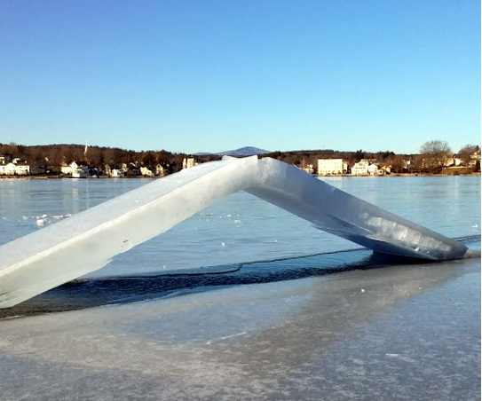
Quote:
In all seriousness though due caution should be employed when approaching or crossing pressure ridges. They can be dangerous. |
|
|
|
|
|
01-18-2019, 01:37 PM
|
#11 | |
|
Senior Member
Join Date: Apr 2004
Location: Whortleberry Island
Posts: 125
Thanks: 16
Thanked 55 Times in 31 Posts
|
Quote:
The winter experience out there is awesome. Go for it! |
|
|
|
|
|
01-19-2019, 12:27 PM
|
#12 |
|
Senior Member
Join Date: Apr 2004
Posts: 753
Thanks: 59
Thanked 271 Times in 129 Posts
|
Rode my sled from Sheps to Mink Island today checking the ice as I went. A number of pressure ridges in this area. The first is near the ramp at the far end of sheps. I went around it. There is another at cattle landing. There are a few flat spots to cross there. Nothing was wet. There is a third one east of Mink that I havent looked at yet. Bottom line is I found 7-9+ inches everywhere with some snow ice on top of that.
|
|
|
|
| The Following User Says Thank You to Mink Islander For This Useful Post: | ||
MAXUM (01-19-2019) | ||
|
01-21-2019, 04:24 PM
|
#13 |
|
Senior Member
Join Date: Apr 2004
Posts: 753
Thanks: 59
Thanked 271 Times in 129 Posts
|
Now that its buried in the snow, you might miss this one. If was quite wet yesterday and fairly wide. A lot of ice had sagged below the surface. A couple of 4-wheelers thought better of trying to cross it and found a way around towards Jolly. Im sure if youre cruising along on sleds, theres nothing to worry about and another week of mostly cold weather will lock it in again. But Id be careful even Derby Weekend driving a truck through there.
Be safe and tight lines! |
|
|
|
|
01-22-2019, 03:45 PM
|
#14 |
|
Senior Member

Join Date: Apr 2004
Location: Eastern MA & Frye Island/Sebago Lake, Maine
Posts: 952
Thanks: 254
Thanked 351 Times in 158 Posts
|
Nice clear day to get a look from space....
BT
__________________
" Live for today because yesterday is gone and tomorrow may never come" |
|
|
|
|
01-22-2019, 04:09 PM
|
#15 |
|
Senior Member
Join Date: May 2004
Posts: 962
Thanks: 495
Thanked 274 Times in 175 Posts
|
Note unfrozen Sebago Lake in Maine. 🐻
|
|
|
|
|
01-22-2019, 08:57 PM
|
#16 | |
|
Senior Member
Join Date: Apr 2004
Location: Eastern MA & Frye Island/Sebago Lake, Maine
Posts: 952
Thanks: 254
Thanked 351 Times in 158 Posts
|
Quote:
__________________
" Live for today because yesterday is gone and tomorrow may never come" |
|
|
|
|
|
| Bookmarks |
|
|


 Hybrid Mode
