

|
|
|
|
|
|||||||
| Home | Forums | Gallery | Webcams | Blogs | YouTube Channel | Classifieds | Register | FAQ | Donate | Members List | Today's Posts | Search |
 |
|
|
Thread Tools | Display Modes |
|
|
 08-17-2007, 06:45 AM
|
#1 |
|
Junior Member
Join Date: Mar 2007
Posts: 18
Thanks: 0
Thanked 0 Times in 0 Posts
|
DO you know if the software will work on a Garmin 496?
|

|

|
|
08-17-2007, 09:39 PM
|
#2 |
|
Senior Member
Join Date: Aug 2006
Posts: 292
Thanks: 44
Thanked 36 Times in 33 Posts
|
Bizer provides a test file you can download from the website:
http://www.bizer.com/garmin to see whether it will work on your unit. You need to be able to attach your unit to your computer to do the transfer. NHskier |
|
|
|
|
08-18-2007, 09:48 PM
|
#3 | |
|
Senior Member

Join Date: Jul 2002
Location: Massachusetts
Posts: 336
Thanks: 0
Thanked 243 Times in 82 Posts
|
Quote:
As previously stated, if it doesn't work or if it just isn't your cup of tea, Bizer will refund your $$$ (So far, nobody has asked for their $$$ back). |
|
|
|
|
|
08-18-2007, 11:34 PM
|
#4 | |
|
Senior Member
Join Date: Feb 2006
Location: I'm right here!
Posts: 1,153
Thanks: 9
Thanked 102 Times in 37 Posts
|
Is it possible for someone to show me what you are talking about? (maybe a photo?)
I don't have a GPS on the Winni boat, but I would consider one. Cowislander wrote: Quote:
Please explain if you (everyone) would. Thanx |
|
|
|
|
|
08-19-2007, 01:46 PM
|
#5 | |
|
Senior Member

Join Date: Apr 2004
Posts: 1,325
Thanks: 5
Thanked 0 Times in 0 Posts
|
Quote:
Bizers Garmin version:
 Bizer's normal version: 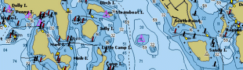
__________________
[Assume funny, clever sig is here. Laugh and reflect...   ] ]
|
|
|
|
|
| Sponsored Links |
|
|
|
08-19-2007, 10:09 PM
|
#6 |
|
Senior Member
Join Date: Aug 2006
Posts: 292
Thanks: 44
Thanked 36 Times in 33 Posts
|
Airwaves,
You can compare a paper Bizer chart with the photos shown on the website page I referenced in an earlier post. You won't see the blue shoals areas or the water depth contours. You will see the islands, rocks, and markers. The C-Map version of the Bizer chart, which can be used on some Standard Horizon units (and others?) is equivalent to the paper chart. NHskier |
|
|
|
|
08-21-2007, 01:32 PM
|
#7 |
|
Senior Member
Join Date: Feb 2006
Location: I'm right here!
Posts: 1,153
Thanks: 9
Thanked 102 Times in 37 Posts
|
So at this point in development the C-Map version in a Standard Horizon unit is more detailed than the Garmin unit's version?
I guess that is what my question boils down to, which unit GPS would produce the best result on Lake Winnipesaukee. As far as paper charts go I was a fan of the single page chart of the lake I find the half on the front and half on the back that Bizer and Duncan now produce a pain so that's why I'm considering adding a GPS. |
|
|
|
|
08-21-2007, 08:52 PM
|
#8 |
|
Senior Member
Join Date: Aug 2006
Posts: 292
Thanks: 44
Thanked 36 Times in 33 Posts
|
The C-Map version has been available for some time and is complete. The Garmin version is new and still in development. So yes, at this point the C-Map version is the best.
While many shops around the lake probably carry the Standard Horizon unit and C-Map chip, I know that Thurston's has the unit on display on the counter in their showroom. Hopefully Bizer has seen enough interest in the Garmin version to continue development and add in the remainder of features in the not-too-distant future. NHskier |
|
|
|
|
08-22-2007, 06:08 PM
|
#9 |
|
Junior Member
Join Date: Mar 2007
Posts: 18
Thanks: 0
Thanked 0 Times in 0 Posts
|
The test download worked on the 496, so I sent my $ for the full file. I will let you know my success with the whole thing when I get it.
|
|
|
|
|
08-23-2007, 05:58 PM
|
#10 | |
|
Senior Member

Join Date: May 2005
Location: Isola Gatto Nero
Posts: 697
Thanks: 162
Thanked 263 Times in 81 Posts
|
Quote:
__________________
La vita è buona su Isola Gatto Nero |
|
|
|
|
|
08-24-2007, 07:07 AM
|
#11 |
|
Junior Member
Join Date: Mar 2007
Posts: 18
Thanks: 0
Thanked 0 Times in 0 Posts
|
Got the software emailed from Bizer and it downloaded perfectly to the 496. Understand it is a prototyple at this point, but it is much better than the "old" C-Chip I had in a 2001 boat. It identifies buoy's and suggested travel routes but lacks the glitz of more developed software. I dont see any reason Bizer won't get there for 2008.
|
|
|
|
|
08-24-2007, 12:59 PM
|
#12 |
|
Senior Member
Join Date: Jun 2007
Posts: 298
Thanks: 14
Thanked 147 Times in 62 Posts
|
Good to hear it works on the Nuvi and the E-trex since I have both. This would be more valuable for me if it had recommended routes around certain markers since a few areas are a bit tricky as you direction changes from N/S to E/W.
|
|
|
|
|
03-17-2008, 01:53 PM
|
#13 |
|
Senior Member
Join Date: May 2005
Location: Isola Gatto Nero
Posts: 697
Thanks: 162
Thanked 263 Times in 81 Posts
|
According to the Bizer web site http://www.bizer.com/garmin/ they have made some improvements. Curious to see if anyone has tried them out (on a sled) since the latest revision.
__________________
La vita è buona su Isola Gatto Nero |
|
|
|
|
06-02-2008, 12:56 PM
|
#14 |
|
Senior Member

Join Date: Feb 2008
Location: Gilford
Posts: 246
Thanks: 146
Thanked 58 Times in 42 Posts
|
I've been trying to load the bizer test file (3islands) onto my Nuvi 200w, but no matter how I try it it does not seem to work. Everything appears to be going smoothly onscreen, but then when I disconnect, go to settings > map, then click "map info" on the bottom of the screen, only my onboard road map is listed as a selectable option. Any suggestions?

|
|
|
|
|
06-02-2008, 05:37 PM
|
#15 |
|
Deceased Member

Join Date: Jul 2002
Posts: 1,701
Thanks: 115
Thanked 25 Times in 13 Posts
|
Overlake97 try this. If you have a NuVi or StreetPilot, please read garmnuvi.doc. http://www.bizer.com/garmin/garmnuvi.doc
Let me know how it works I just got one of these for a 35 year anniversary gift from work. |
|
|
|
|
06-03-2008, 10:23 AM
|
#16 |
|
Senior Member
Join Date: Feb 2008
Location: Gilford
Posts: 246
Thanks: 146
Thanked 58 Times in 42 Posts
|
I had already read the garmnuvi.doc, and followed the procedure, but that seems to describe what to do with the official purchased file, not the "test" 3islands file. I did everything the garmnuvi.doc suggested, except for changing the name (which seemed to relate to the full operational file). There is also a 'read me' file which downloads along with the zipped 3islands test file. That describes a slightly different procedure, which also did not work.
The person answering the phone at BIZER said he'd never heard of it not working on any particular Garmin unit, so I'm still hopeful. Maybe I'll call him again.
|
|
|
|
|
06-03-2008, 10:59 AM
|
#17 | |
|
Senior Member
Join Date: Jul 2002
Location: Massachusetts
Posts: 336
Thanks: 0
Thanked 243 Times in 82 Posts
|
Quote:
|
|
|
|
|
|
06-03-2008, 12:04 PM
|
#18 |
|
Senior Member
Join Date: Feb 2008
Location: Gilford
Posts: 246
Thanks: 146
Thanked 58 Times in 42 Posts
|
Thanks BIZER! I changed the name from 3islands to GMAPSUPP.IMG as instructed on the garmnuvi.doc page (and as you noted above), then dragged that file into the Garmin (K) folder showing on "my computer" (Dell laptop). Then I opened the Garmin (K) folder/directory and further dragged the GMAPSUPP.IMG into the Garmin folder inside.
That last step was essential, as just dragging the file into the main Gamin (K) folder/directory (where it showed up besides "Garmin" and "JPEG" folders on my system) did not do the trick. Meaning, opening settings > maps > map info [at screen bottom] on the nuvi did not show that the map had been downloaded. After doing the second drag, the test map appeared there just as described in the garmnuvi.doc page. I seleced it, de-selected the other (main) map, went back to the screen, and there it was! Long, Cow and Bear islands - with buoys showing. So, the test worked and my check for winni-g2 is in the mail! |
|
|
|
|
06-05-2008, 10:52 PM
|
#19 |
|
Senior Member

Join Date: Jan 2003
Location: Alton Bay
Posts: 5,602
Blog Entries: 2
Thanks: 2,468
Thanked 1,983 Times in 1,083 Posts
|
Test worked fine, once I figured out how to zoom in. No difference with the Streetpilot as far as color goes...buoys were the same color...no matter, it's not my primary navigation tool anyway as I will always have my Bizer chart handy as well. Oh yeah, my check is in the mail as well.
thanks bizer.
__________________
I Live Here... I am always UPTHESAUKEE !!!! |
|
|
|
|
| Bookmarks |
|
|


 Hybrid Mode
