

|
|
|
|
|
|||||||
| Home | Forums | Gallery | Webcams | Blogs | YouTube Channel | Classifieds | Register | FAQ | Donate | Members List | Today's Posts | Search |
 |
|
|
Thread Tools | Display Modes |
 09-01-2005, 09:21 PM
|
#1 | |
|
Senior Member

Join Date: Jan 2005
Location: Florida (Sebring & Keys), Wolfeboro
Posts: 5,943
Thanks: 2,218
Thanked 779 Times in 555 Posts
|
After the Hurricane of 1938 destroyed the huge maple syrup enterprise of his family, the late Ralph Merwin Horn asked his father if he could finally build an airport on their 100+ acres of Wolfeboro Neck property. With permission granted, Merwin (as he was known to us) pulled the stumps of hundreds of mangled maple trees.
Wolfeboro townspeople helped pull stumps too, with tractors and trucks. ('Can't just cut trees down for a runway -- the stumps have to go, too). World War II intervened, and Merwin -- already well trained in flight -- trained many of this country's military aviators at a school in the Boston area. Shortly after his death, about 1996, a gift of a memorial headstone was made and stands today next to the runway. Someone always remembers to place a flag next to it every Memorial Day. Merwin married Eleanor, and the two put in exhausting hours -- for four decades -- to make the airport the busy enterprise it finally became. Often there would be four floatplanes at the dock, dozens of aircraft at the tie-downs, three or four aircraft in the hanger for repairs/maintenance, and takeoffs and landings day and night. It is my hope to have Forum members post their recollections of these remarkable people here. There are certainly many seaplane pilots who can relate some tales of "The Lakes Region Airpark". I found one by accident while searching the Internet for SeaBees, an amphibious aircraft manufacturer. Quote:
My main source of Wolfeboro's Airpark history is a former employee who I see from time to time. I'll endeavor to share stories from the airport's heydays...when I can get them. Labor Day Edit: I recalled today that Ralph (earlier, Merwin) would get radio transmissions from pilots advising of their arrival after dark and, at dusk, would light fifty black "smudge pots" (possibly the "Dietz-torch" variety) around the runway by hand. (It's a 2500-foot runway). The lighting was electrified later, but don't recall when. Later yet, the electric lighting could be triggered to light automatically by pilots' radios. The system was discontinued some time after Ralph's death in 1997. The airport beacon was discontinued about 2000. Though Ralph appeared healthy as a New Hampshire ox in 1996, I conducted a videotaped interview of him that summer and will donate it to the Wolfeboro Library this week. (You wouldn't believe how often the word "oxen" appears in the building of towns around Winnipesaukee on this tape). Aha!...A link, though sadly outdated: http://www.brewsteracademy.org/Pages...y/airpark.html Last edited by ApS; 02-22-2024 at 03:00 PM. |
|

|

|
| The Following 2 Users Say Thank You to ApS For This Useful Post: | ||
Airedale1 (12-20-2012), PapaBarnCat (05-25-2011) | ||
|
09-07-2005, 10:08 AM
|
#2 |
|
Senior Member
Join Date: Jul 2005
Posts: 262
Thanks: 0
Thanked 23 Times in 11 Posts
|
I was sad to see that the plan to develop 38 residential homes on the site is progressing....
|
|
|
|
| The Following User Says Thank You to MJM For This Useful Post: | ||
PapaBarnCat (05-25-2011) | ||
|
09-12-2005, 07:41 AM
|
#3 |
|
Senior Member
Join Date: Jan 2005
Location: Florida (Sebring & Keys), Wolfeboro
Posts: 5,943
Thanks: 2,218
Thanked 779 Times in 555 Posts
|
I was reminded that Wolfeboro's well-known, and highly regarded Lakeview Inn was once Ralph Merwin Horn's family residence at the airport.
I recall that it was moved on the ice across the Broads and up the hill (and it's some hill) to its present location by teams of oxen! Ralph stated that they had to move quickly because the water became four inches deep as the house passed over the ice. Yes, the airport runway -- though busy as ever before -- is scheduled to be torn up this year. Homesites are priced from $300,000 for the "cheap seats", to $4½ Million. Home sites. |
|
|
|
| The Following User Says Thank You to ApS For This Useful Post: | ||
PapaBarnCat (05-25-2011) | ||
|
10-14-2005, 07:58 PM
|
#4 |
|
Senior Member
Join Date: Jan 2005
Location: Florida (Sebring & Keys), Wolfeboro
Posts: 5,943
Thanks: 2,218
Thanked 779 Times in 555 Posts
|
Here's another site describing the airport's more technical points: http://www.fltplan.com/AirportInformation/69NH.htm
(The address and telephone numbers are no longer attended to). About fifteen years ago, I had an occasion to speak with Ralph "Merwin" Horn again. At the time, however, he was distracted by a recurring problem with the new airport beacon light. Ralph was in the process of packaging up the remains again to send in under warrantee when I arrived. The beacon had been a good "advertisement/reminder" for the airport, and was printed on thousands of maps of Lake Winnipesaukee. (Even unlighted during the daytime it is still tall enough to be a landmark). Included with the beacon, an entire airport lighting system was provided at no cost to the airport some time in the '80s. A gift from the Wolfeboro civic organizations Rotarians and Masons, the beacon's lenses kept breaking the pieces falling to the ground. A Town of Wolfeboro volunteer would climb to the very top to replace the lenses each time. The beacon (and all the airport lighting) stopped operating altogether after his death. In the hour I spent visiting in the hanger and examining the glass fragments, my first inclination was that the light was being "shot out" by somebody. Ralph never mentioned the possibility of such an outrage and my own suspicions stayed to myself. Ralph spoke proudly of the Lakes Region, and never spoke badly about individuals (except for pilots doing bad fly-things at the airport). A very hard worker, and keeping very long and unsteady hours into his later years, he remains today my favorite "archetype" of a native Granite-Stater. His ashes were spread over the airport in 1997. (Eleanor's ashes had preceded his by a few years). In the end, both had "given their everything" to the Lakes Region Airpark of Wolfeboro. |
|
|
|
| The Following 2 Users Say Thank You to ApS For This Useful Post: | ||
mac1982 (07-16-2013), PapaBarnCat (05-25-2011) | ||
|
10-18-2005, 10:25 PM
|
#5 |
|
Member

Join Date: Apr 2004
Location: Portsmouth, NH
Posts: 49
Thanks: 0
Thanked 0 Times in 0 Posts
|
Correct me if I am wrong, but isn't it closed now?
|
|
|
|
| Sponsored Links |
|
|
|
10-19-2005, 06:46 AM
|
#6 |
|
Senior Member
Join Date: Jan 2005
Location: Florida (Sebring & Keys), Wolfeboro
Posts: 5,943
Thanks: 2,218
Thanked 779 Times in 555 Posts
|
Good question: It depends on your meaning of "Closed".
While the runway is in good condition, a big "X" was painted on the runway a couple of years ago, which should have indicated "Closed" back then. But flights continue. The east landing-approach from Wolfeboro direction is actually more friendly now that Johnson's Cove trees have been cut down. Floatplane access has been stopped: Shortly after Ralph Horn died, his new floatplane docks were torn up. (Which started some serious lobbying and lawyering with the State of New Hampshire Attorney General, who tried to enforce a 1984 law keeping small NH airports as local resources). The AG is still "involved", but I don't know how as yet. Even today, the occasional floatplane will taxi the shoreline -- trying to find those docks. Fees have been raised: Gas, services, lighting, storage, and maintenance have been gradually restricted to pilots over the past years; however, there are regular users every decent flying day -- and, for October, many visitors -- perhaps for leaf-peeping? October activity included helicopters (private and government -- some very large) and twin- and single-engine aircraft -- night and day. There were three visits made by an immense Russian Antonov AN-2 biplane just last week. Very impressive sight and sounds! From my boat, I watched a Cessna make an approach on Monday's very blustery late afternoon, but he declined to land. There is some commercial boat/trailer outdoor-storage activities going on there presently, and may have presented a landing hazard. Sunset is the best time for us airport-junkies to watch this "closed" airport in action. |
|
|
|
| The Following User Says Thank You to ApS For This Useful Post: | ||
PapaBarnCat (05-25-2011) | ||
|
10-19-2005, 12:53 PM
|
#7 |
|
Senior Member

Join Date: Apr 2004
Posts: 5,075
Thanks: 215
Thanked 903 Times in 509 Posts
|
I know I sound like I'm stirring things up APC but why is an"offshore" boats' loud motor such an annoyance and an "immense Russian Antonov AN-2 biplane" noise "very impressive".Very confusing isn't it?
__________________
SIKSUKR |
|
|
|
|
10-20-2005, 06:56 AM
|
#8 |
|
Senior Member
Join Date: Jan 2005
Location: Florida (Sebring & Keys), Wolfeboro
Posts: 5,943
Thanks: 2,218
Thanked 779 Times in 555 Posts
|
Ah...Grasshopper.
 It is the Antonov's radial engine that makes the difference. Like the sound that a Harley-Davidson makes from its own antique design lineage, a radial engine makes a very distinctive sound: If it's flying over Winnipesaukee, you can detect it. The radial engine sound has even produced a cottage industry in CD recordings. (You can listen on-line!) http://www.spitcrazy.com/sounds_of_aviation.htm http://rareaviation.com/raenfrso.html One recording company has even added music to the sound: http://sounddogs.com/results.asp? (Vocals!) I don't know of any similar recordings of any other engine. Too, it is the sound of our WWII American "Warbird" legacy. These designs produced engines of 3600+HP from a single engine. Here's the radial engine principle. Like some boats on Winnipesaukee, Harley-Davidson motorcyclists try to project a kind of "Warbird" image. (Paint jobs, graphics, decals, leather jackets and "character"). It's just ridiculous that our Warbird legacy of WWII could be matched or experienced through paint jobs and appearances: think "poseur". All the other engine sounds that strike my ear at Winnipesaukee are projected through noisy Detroit-Iron exhaust pipes, housed in expensive fiberglass jukeboxes. And the Antonov has never awakened me in the middle of the night. APS Last edited by ApS; 04-03-2009 at 04:07 AM. Reason: Add "poseur" |
|
|
|
|
10-20-2005, 12:57 PM
|
#9 |
|
Member
Join Date: Apr 2004
Location: Portsmouth, NH
Posts: 49
Thanks: 0
Thanked 0 Times in 0 Posts
|
So the difference is the nostalgia? A half-century old Harley that is running like crap does not sound good. Most well tuned engines have a good sound to them, to a gearhead anyways. A well dialed-in Formula1 engine has its own high pitch scream while big Detroit iron has its own rumble, as does a race-ready Ducati. Very different sounds, but all pleasing to the ear. I will agree that well-tuned radial engines have a great sound to them. Radials are usually very loud. To say that it does not annoy people because it is a radial instead of another configuration does not make sense. What about something like a P-51 or a Spitfire? Do those sound good? They don't have radials, but fit in to the nostalgia idea...
|
|
|
|
|
01-04-2006, 09:53 AM
|
#10 |
|
Senior Member
Join Date: Jan 2005
Location: Florida (Sebring & Keys), Wolfeboro
Posts: 5,943
Thanks: 2,218
Thanked 779 Times in 555 Posts
|
I was recently regaled by a "Greatest Generation" friend of Ralph Horn's that Ralph once had a buyer for one of his aircraft. The only stipulation was that it had to be delivered THAT DAY!
Scanning the runway with its two feet of snow on it, Ralph got out the snowplow and plowed a track to the runway, clearing about one third of the runway's length. (The east end, at Johnson's Cove). He then taxied the aircraft to the very end, and took off diagonally, using every inch of the cleared runway. He overflew the "T"-hangers pictured below by a few feet and delivered the aircraft -- that day. Hey, the guy trained WWII pilots -- who's going to argue? 
__________________
Is it  "Common Sense" isn't. "Common Sense" isn't. ")
|
|
|
|
|
08-20-2006, 03:17 PM
|
#11 |
|
Junior Member
Join Date: Sep 2005
Posts: 8
Thanks: 0
Thanked 2 Times in 1 Post
|
I've been travelling to Winnipesaukee every August for the past sixteen years. For most of that time, Lakes Region Airpark was the way we got there. Even now, three years after I last used the airport, it seems strange to get there any other way. To me, the Airpark was the heart and soul of the Lakes Region. Wolfeboro meant Airpark. The seaplanes tied up at the dock were evocative of the north woods. Coming over the dark ridges of trees to the narrow little runway, surrounded on three sides by clear water, it was obvious that I was a long way from Washington, DC, if not in another world entirely.
Over my sixteen years, I got a once-a-year snapshot of the Airpark, and watched its fortunes rise and fall. There was a golden period in the mid-1990s when there were lots of people there, even a Saturday hamburger cookout. Then, there was a bleak period of deterioration and no fuel available. In the late 1990s, there was a brilliant recovery, anfd the airport returned to health. This was short-lived, and the facility went into its final decline. At the end, I had to use my own stakes to tie the aircraft down and it required a long negotiation to get a local car rental place to transport us between the airpark and the Sandy Island dock. Laconia and, finally, Moultonboro were so much more convenient, had fuel, and offered a quicker trip to the island. I felt disloyal not to use Wolfeboro, but the airport was becoming almost impossible to use as a gateway to the region. This summer, they started digging up the runway. Lots of little houses on the way, all built out of ticky-tacky and all looking just the same. All part of a general pattern of removing beauty and individuality from Wolfeboro. Then again, if people don't appreciate what they have, they deserve to lose it. One of the good things about using Moultonboro Airport is that I can come for a two week stay on the island without every having to spend a dime at, or even see, that town that threw away their beautiful airport. Paul |
|
|
|
|
10-16-2006, 08:54 AM
|
#12 |
|
Senior Member
Join Date: Jan 2005
Location: Florida (Sebring & Keys), Wolfeboro
Posts: 5,943
Thanks: 2,218
Thanked 779 Times in 555 Posts
|
Lots of Lakes Region pilots get misty about the airport and thinking of the supreme effort put forth by the Horn family to get it there.
Planes still "shoot" the runway, and it may be possible to land a plane there today-though it's still uphill  ) )Here's a photo of the tiedown area in its "Happy Skies" days: 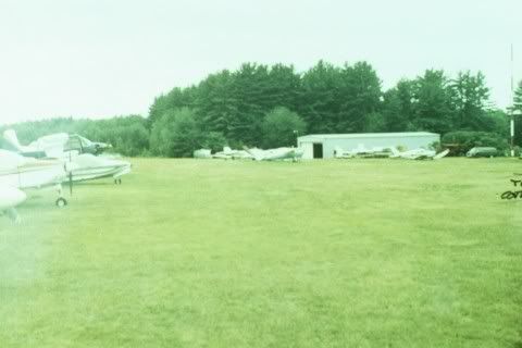 Atop the red and white pole at the extreme right is the airport's beacon. It appears on many charts of the Lake Region as "flashing green and white".
__________________
Is it "Common Sense" isn't.
|
|
|
|
|
10-20-2006, 12:39 PM
|
#13 | |
|
Senior Member
Join Date: Apr 2004
Location: NH
Posts: 2,689
Thanks: 33
Thanked 439 Times in 249 Posts
|
Quote:

|
|
|
|
|
|
07-09-2007, 06:06 AM
|
#14 |
|
Senior Member
Join Date: Jan 2005
Location: Florida (Sebring & Keys), Wolfeboro
Posts: 5,943
Thanks: 2,218
Thanked 779 Times in 555 Posts
|
It was intended for floatplanes, but with this super-long gas line you could fill up your boat with 100 octane gasoline at the water's edge. (And some neighbors did). Town concerns resulted in having the pump removed.
 The pump was replaced by a big gasoline tank in a 1-ton pickup's bed! On the driver's seat was a clipboard where you would post the number of gallons you used and your address. You wouldeventuallybe sent a bill. (The Honor System until 1997, when the delivery system was again dramatically changed). This re-photo, from the mid-60s, shows how crowded Winter Harbor could get on a sunny day! (That's the truck's door to the left). 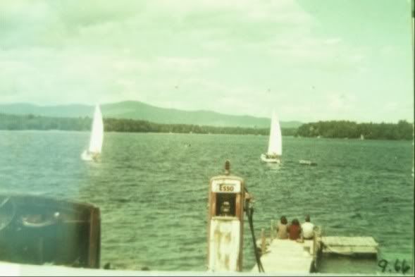
__________________
Is it "Common Sense" isn't.
|
|
|
|
|
09-08-2007, 06:55 AM
|
#15 |
|
Senior Member
Join Date: Jan 2005
Location: Florida (Sebring & Keys), Wolfeboro
Posts: 5,943
Thanks: 2,218
Thanked 779 Times in 555 Posts
|
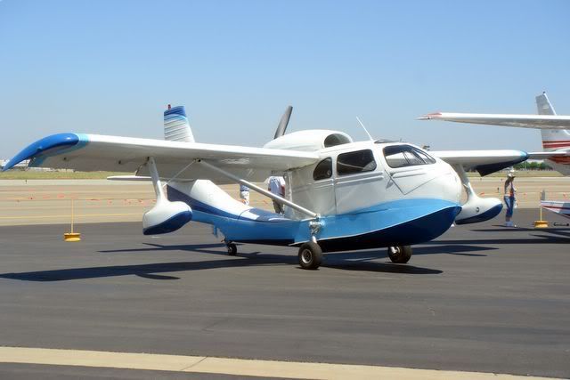 An identical amphibian, but in silver, flew low over the airport runway yesterday. It appeared to be giving homage to our bygone Wolfeboro assets of float- and land- plane havens. Since the Republic SeaBee amphibian continuously operated out of the Wolfeboro Airpark for half a century, I saw yesterday's flight as an omen for me to post an update!  Ralph Horn always bemoaned that he hadn't bought the heavily forested eastern approach to the airport, as landing approaches had always been a challenge from that direction. (Some pilots would say "challenge" isn't a strong enough word).  His abutter, Brad Frankum, never "harvested" those big white pines, and allowed his extensive estate to return to Old Growth. While most of the airport-end of Wolfeboro Neck is packed with soggy clay, Frankum's area is one giant granite outcropping. (Now heavily dynamited and fractured). While not an expert in geology, the old ledge appears to have halted the glacier's southern push of lake bottom clay from 20,000 years ago. From the original grass strip, the paving of the runway had always been fraught with big puddles in summer and frost heaves in spring. The first paving didn't last one year! But last year, those old Forest Giants were felled from the southern end and the entire paved runway was bulldozed. What had been the old runway was filled with a bazillion truckloads of dirt to extend it several hundred feet—from where it had previously ended in a soggy rockpile. That rockpile, in turn, had been "harvested" from the dredgings of the Walgreen's McMega-Boathouse moat nearby. The dynamiting for that moat shook the ground and air ten times worse than any New Hampshire earthquake has. I'll bet it was heard in Center Harbor! The entire runway "terra-forming" got a hydroseeding last year, so it now looks like a pasture. (Well, it did in Spring, before our present drought ).The intent was to make housing lots, but it's a perfect grass landing strip today, with the approach opened up and "the runway" finally extended. Maybe the new owners heard that FedEx is now paying Big Bucks to lease air-delivery rights for their smaller freight aircraft! (Which is especially true today, as even the future of Rochester's Airport—Skyhaven—remains gloomy). Here's a newer view of the hanger—in the distance—during the "terra-forming": 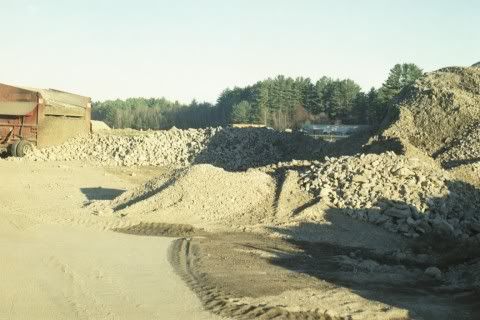
__________________
Is it "Common Sense" isn't.
Last edited by ApS; 12-20-2012 at 06:50 AM. Reason: ...direction of approach is east, not south... |
|
|
|
|
02-22-2008, 05:07 AM
|
#16 |
|
Senior Member
Join Date: Jan 2005
Location: Florida (Sebring & Keys), Wolfeboro
Posts: 5,943
Thanks: 2,218
Thanked 779 Times in 555 Posts
|
This photo, taken from a Piper Cub, shows the airport's abutting floatplane area with two floatplanes on ramps and one other at the dock. (Diamond Island and Rattlesnake Islandwith no houses yet built on the Broads sideappear in the hazy distance).
Because the runway wasn't paved as yet, the photo could have been taken as early as 1957. My guess on the date would be 1961. The floatplane gas pump, photographed lakeside in 1966, doesn't appear here. A large blue hanger, built in 1971, also doesn't appear. (It would have appeared under the Cub's strut). The paved runway was removed a couple of years ago by a developer, so the same aerial taken in 2006 would have shown a greener, but identical, scene! (OK, there would be no "peppering" of Florida mildew on the slide ). 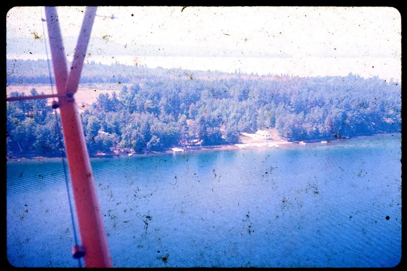 Since 2006, three McMansions have been built and five docks added. The lakefront white cottage prominent in the photo was upgraded inside and out at a cost of $200K in 1999. It has today been replaced by a spec-built McMansion advertised for $3.9M. (If you don't like the design of the spec-built, there's a buildable lakefront lot available nearby for $4.2M). After 40 years, the runway has reverted to a grass landing strip once again. An approach for a landing on the strip has never been easier, as many cathedral pines on adjacent cove lots have been removed. The runway has even been extended in both directions beyond anyone's imagination, and the landing strip's sides could someday be lined with houses with individual hangers. The commercial hanger (not pictured here) remains to this day: Ralph Horn's distant dream of a "Hanger Community" (residences lined up on a landing strip) is still possible! 
__________________
Is it "Common Sense" isn't.
|
|
|
|
|
09-14-2008, 09:43 PM
|
#17 |
|
Senior Member
Join Date: Jan 2005
Location: Florida (Sebring & Keys), Wolfeboro
Posts: 5,943
Thanks: 2,218
Thanked 779 Times in 555 Posts
|
You read it here first!
The entire airport property has been re-sold to the Marriott Family: The price is yet unknown. The seller, an insider, paid $750,000 for the airport in 1995on a literal handshake with Ralph Horn. The Marriotts own a huge chunk of contiguous waterfront properties on Tuftonboro Neck (in sight of the airport) and have been looking to buy abutters' properties which have much calmer waters on which to waterski. One recent photo shows one end of the existing estate, so the Marriotts aren't likely to rebuild the airport or to replant the area in forest. BTW: I just learned that it was a Marriott executive who encouraged Mitt Romney to buy a Wolfeboro waterfront place ten years ago. Since groundbreaking and dynamiting early last year, that one lakefront lot is still under construction with the usual McMansion on a lot that extends about 300' wide, and extends nearly 400' from the water's edge. Lot sales have been non-existant, with the "model home" (below) rarely visited. It may have been that rugged, winding, jarring start to a 4-mile-ride to Wolfeboro that failed the developer. At only 20', the lake is not particularly deep between the paired estates (Ayer's Point to Thomas Point), so a bridge constructed between the two Marriott mega-estates can't be ruled out. Upon the 1995 airport tract's approval for development, the Town of Wolfeboro was promised that half of the land would remain as original forest "In Perpetuity". So far, so good. The saga continues: Will it be bulldozed once again? Will Ralph Horn's memorial headstone be moved once again? Or will there be a "Marriott-Wolfeboro Airport"? 
__________________
Is it "Common Sense" isn't.
|
|
|
|
|
09-15-2008, 07:22 AM
|
#18 |
|
Senior Member

Join Date: Jan 2006
Posts: 6,767
Thanks: 754
Thanked 1,462 Times in 1,018 Posts
|
If it is all true, Acres, your last question is very interesting. I do know that years ago the sons wanted to build an airport by their existing property but JW said over his dead body. So now may be the time. JW (first) has been gone for quite a few years now.
|
|
|
|
|
11-25-2008, 08:41 AM
|
#19 |
|
Senior Member

Join Date: Jul 2002
Location: Rock Haven Lake - West Newfield, ME
Posts: 5,367
Thanks: 374
Thanked 1,057 Times in 495 Posts
|
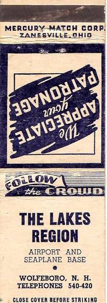
Acres Per Second: I've looked everywhere for photos to add to this interesting thread but this is all I've come up with!
__________________
|
|
|
|
|
12-08-2008, 06:50 AM
|
#20 |
|
Senior Member
Join Date: Jan 2005
Location: Florida (Sebring & Keys), Wolfeboro
Posts: 5,943
Thanks: 2,218
Thanked 779 Times in 555 Posts
|
Thanks for finding that.
It's interesting that the final name for the airport was "The Lakes Region Airpark", and not what's printed there. I've sent out a few feelers to determine what date that matchbook was first seen. For a possible date on that matchbook cover, you've got me studying phillumeny on the Internetthe collection of matchbook covers. What started that study was the appearance of the striking surface on the "front" of the matchbook: I recall that feature was phased out some years ago. That unsafe feature was very handy when lighting-off a backyard pile of dry brush when you would want to throw the whole lighted matchbook, but be far enough from the pile when using old gasoline as a starting fluid! The last possible date, it turns out, was 1975 of a phase-out that began in 1965so now those phone numbers need some work. My immediate neighbor didn't recall that matchbook either, but I remember the "420" number as being the lakeside residence abutting the floatplane ramps, as pictured in the aerial photo. Where "740" rang may have been Merwin and Eleanor Horn's former Sewall Road winter residence, but might have been shared with the workshopnow razedattached to the northern end of the T-hangers pictured here earlier. (A photo of the workshop appears below). Just when the telephone numbers changed to the usual seven digits in Wolfeboro I don't recall, but based on a list of Wolfeboro emergency numbers I've saved, it may have been in the late 50s. Edited to update: That match company started in 1954, and ceased operations in 1964. Wolfeboro may have converted to convential telephone numbers as late as 1964! When I return to the lake, I can do some more sleuthingwith the list saved from that era. What was remarkable is that I apologized to my immediate neighbor about not having a telephone back then. Her reply was that, "None of us had telephones back then". (So why ruin Paradise with "modern communications", anyway).  In truth, appearing at the doorstep with the question, "Y'wannago waterskiing today?" was always a great way to start off a sunny day on Winnipesaukee. (Though we also skied in drizzle and rain wearing ski goggles! )I've learned that "Merwin" (as we knew himnot Ralph) is how his family still refers to him, and that Eleanor was an immigrant from Nova Scotia. I recall Eleanor being particularly giddy many years ago about Rt 16 being widened all the way from Rochester, which would "bring more customers to the airport".  So...I'm sending more "feelers" out on this to peg the date closer than the late 50smy best guess today. The Airpark's heated, and quite-serious aircraft workshop, photographed in 2004:
__________________
Is it "Common Sense" isn't.
Last edited by ApS; 12-18-2008 at 06:44 AM. |
|
|
|
|
02-25-2009, 07:02 PM
|
#21 |
|
Senior Member
Join Date: Jul 2002
Location: Rock Haven Lake - West Newfield, ME
Posts: 5,367
Thanks: 374
Thanked 1,057 Times in 495 Posts
|
__________________
|
|
|
|
|
08-19-2009, 05:34 AM
|
#22 |
|
Senior Member
Join Date: Jan 2005
Location: Florida (Sebring & Keys), Wolfeboro
Posts: 5,943
Thanks: 2,218
Thanked 779 Times in 555 Posts
|
That this is from 1956 doesn't surprise me. This is the old grass landing strip, which was normal for the times and for the region. There was no telephone service—or even electricity service—ten years earlier.
The runway wasn't paved until years later. Having failed because of the freezing and heaving of underground springs, the runway was properly "plumbed" underneath and repaved the following year. Even after decades of weekly mowings, the clear-cut seen at the lower right has slowly grown back. This property lies near the end of Forest Road. Forest Road got its name because it was a dark forested tunnel to drive through to reach the end. Though I have wandered through Forest Road's many forested acres, I can't recall that the clear-cut in the photo ever existed! Not pictured there is the blue airpark hanger, added in 1979 and still in place today. The three-digit telephone number style went out by 1964. The small-appearing shoreline "notch" at the most distant part of the runway is the opening to Johnson's Cove, which lies further to the right in this still-heavily-forested photo. The airport's developer—who bought much of Johnson's Cove—had a disagreement with the town regarding a property tax increase and, among other reasons, the whole works is now in foreclosure. In 1956, Camp Wyanoke lay beyond that "notch", and reached nearly to Carry Beach. (Far right-hand corner of Winter Harbor, with Jockey Cove and Wolfeboro Bay lying beyond Carry Beach in the hazy distance). Aside from one lakefront lot, which now sports a McMansion, just one structure ( a "model home") has been built since the runway was torn up in 2006. The huge grassy clearing across the water from the former Camp Wyanoke is most likely the Melanson property off Highland Terrace in Wolfeboro. Melanson is the local realtor family who, among current (and many other offerings), sold Rattlesnake Island lots subsequent to this brochure's printing. Rattlesnake Island lies "just around the corner" from Wyanoke's Winter Harbor and—to relate it to this photo—would appear about a mile to the right of this photo.
__________________
Is it "Common Sense" isn't.
Last edited by ApS; 09-08-2009 at 05:36 AM. Reason: Add details... |
|
|
|
|
08-19-2009, 03:12 PM
|
#23 | |
|
Senior Member
Join Date: Jun 2008
Location: Portsmouth. RI
Posts: 2,231
Thanks: 400
Thanked 460 Times in 308 Posts
|
Quote:
Comparing old aircraft engines with modern GFBL engines is a stretch. None of the "Round"... (Radial)... engines, or even the water cooled V-12s found in Spitfires or P-51 Mustangs turn much faster than about 2800 RPM, and cruise at 2100 RPM, so the sound is nothing like todays big V-8s that turn over 8000 RPM in some cases. One has to actually HEAR a big Radial start up from COLD, from just a few feet away to get an inkling of what facinates classic aircraft buffs. I would drive 100 miles just to get close to one when it starts up. I also like to hear the go fasts when thay start up as well. My wife says it's a guy thing. NBBTW: Favorite Old Coot pastime...."Lets Go To The Airport"...you never know what you might see...
Last edited by NoBozo; 08-19-2009 at 04:42 PM. |
|
|
|
|
| The Following User Says Thank You to NoBozo For This Useful Post: | ||
old coot (10-17-2010) | ||
|
08-08-2010, 06:03 AM
|
#24 | ||
|
Senior Member
Join Date: Jan 2005
Location: Florida (Sebring & Keys), Wolfeboro
Posts: 5,943
Thanks: 2,218
Thanked 779 Times in 555 Posts
|
Quote:
'Tis true. (Oops...sorry, tis!)  1) I was at an airshow and found a booth selling expensive ear protection. They showed some "electronically-active" ear protectors that I dearly needed in my career (based completely on explosive noises). The demonstration (to have been diminished by the ear protectors) was a CD-recording of a radial engine starting-up. The recording was designed to be loud—and it was!  Though I "passed" on those ear protectors, I did purchase that same CD! At my Dad's 92nd birthday last year, I gave him that CD as a present. (And some "PBY-Warbird" books and reference materials from Amazon.com to benefit Winni.com). He heard the radial engine starting up—identified it as to manufacturer (!)—and "spoke" to the pilot saying, "Check that second magneto!" 2) As my Dad and I live only two miles apart, we both listen for that distinctive "radial sound" over Lake Winnipesaukee. Last week, it was a Russian "Yak" doing aerial acrobatics over Rattlesnake Island. Yesterday, it was a white Waco biplane flying slowly into strong winds: last Wednesday, he advised of seeing a rare "Stinson Gullwing" flying low over his house: 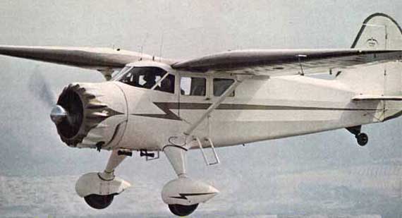 The "Stinson Gullwing" was made in about a dozen models, but don't ask me how he identified it as an SR-7! 3) This week, while searching for something totally unrelated I found this AP blurb that references the State's participation in the 90's sale of the Airpark:Quote:
4) On the topic of floatplanes in the Lakes Region, in late July of 2011, my 94-year-old Dad happened to mention Dr. Libby and that Dr. Libby flew a Stinson Gull Wing on floats, and stored it on a ramp on Mirror Lake close to the museum.  Dr. Libby's takeoffs and landings from Mirror Lake would have been spectacular, but those events had long preceded nearly all of us—including everybody living on Mirror Lake today. My Dad comes up with some astonishing trivia: Just to check his memory after a story following the Korean War, I asked what the specific military designation of the plane he landed in, which was a "Twin Beech". He promptly answered, "R-32". Actually, the desingation could have been something else—rather than R-32—but I can't be expected to remember a designation three characters long for three entire days!
Last edited by ApS; 08-01-2011 at 06:07 AM. Reason: Added photo—trying to correct "designation" misspelling... |
||
|
|
|
|
08-08-2010, 09:37 AM
|
#25 |
|
Senior Member
Join Date: Jan 2010
Posts: 620
Thanks: 259
Thanked 158 Times in 100 Posts
|
So Hughes could not buy it BUT Marriotts could. Wonder why?
|
|
|
|
|
10-22-2010, 11:19 PM
|
#26 |
|
Senior Member
Join Date: Jan 2005
Location: Florida (Sebring & Keys), Wolfeboro
Posts: 5,943
Thanks: 2,218
Thanked 779 Times in 555 Posts
|
Can't say. It appears the state lost its fighting will to keep this little airport as a little airport.
This particular dispute centered around developing the former "Seaplane Base". From his vehicle, Ralph Merwin Horn is videotaping the delivery of the newest floatplane ramp in 1996. His summer cottagewhich received electricity in 1949is shown in the background. It received $120,000 in upgrades (fireplace, wood flooring, triple-pane windows, and a huge porch) in about the year 2000. Six years later, the entire cottage was bulldozed.  The three lots used as the floatplane base (pictured) could have had two McMansions built on it, except that it was "just-shy" of about 15-feet of the legally-required waterfront. As stated, the cottage was torn down and a three-fireplace Mega-McMansion replaced itrequiring three years of spec-building!Since this particular shoreline was nearly treeless, the new structure instantly acquired one of the most-desired features to be found in lakefront homes: a lake-view from every room in the house. Out of view to the far left, their 100-ft-wide abutter has a wing-span-wide easement across its corner: that width was required formerly to tow floatplanes needing repair or storage to the appropriate facility uphill. That same "fractured" lot acquired a shared leachfield with its other neighborin 2004. Both properties havemeantimeexpanded the number of their bedrooms.
|
|
|
|
|
05-25-2011, 09:52 PM
|
#27 |
|
Member

Join Date: May 2011
Location: Sudbury, Ma.
Posts: 20
Thanks: 8
Thanked 4 Times in 4 Posts
|
I just, as a "newbie" stumbled on this thread. I want to thank all the participants in this thread. My late father was an avid pilot many years ago, prior to marrying my mother and then me coming along. He used to affectionately refer to Merwin and the Airport, so I've always felt it was a part of his enjoyment of flying and love of the area. I'm not ashamed to admit that reading this was the trigger that allowed a good part of the grief that had been repressed for fifteen or so years to pour out.
|
|
|
|
| The Following User Says Thank You to PapaBarnCat For This Useful Post: | ||
ApS (09-03-2015) | ||
|
07-20-2011, 01:39 PM
|
#28 |
|
Senior Member

Join Date: Nov 2004
Location: Bear Island
Posts: 642
Thanks: 349
Thanked 145 Times in 77 Posts
|
Is it still just the single model home or have others been built?
Who knows...if it stays the way it is and goes up for sale in 3-5 years, I may just have to make an offer. Of course I'd leave it just as it is...the way it was meant to stay.
__________________
Dream out loud. |
|
|
|
|
07-20-2011, 06:19 PM
|
#29 |
|
Senior Member
Join Date: Jan 2006
Posts: 6,767
Thanks: 754
Thanked 1,462 Times in 1,018 Posts
|
THe Marriots have bought it.
|
|
|
|
|
07-20-2011, 09:35 PM
|
#30 | ||
|
Senior Member
Join Date: Jan 2005
Location: Florida (Sebring & Keys), Wolfeboro
Posts: 5,943
Thanks: 2,218
Thanked 779 Times in 555 Posts
|
Quote:
Like yours, he has two dogs that have no trouble finding porcupines. The Golden Retriever reportedly leads the Black Lab astray! Nothing's changed from last year. I understand the Marriotts intend to add new homes as the family grows. Marriottboro, New Hampshire? Quote:
The only "grace" is that the change has been gradual since Merwin's 1997 death. Breaking-up the floatplane ramps on the shoreline was a tough "message" for our neighbors and the many floatplane pilots who'd frequented the ramps. No more repairs, no storage, no transport, no maintenance, no fuel, no modificationsno more "shop talk". Everyone here loved it as their hard work succeeded to "make a name". He managed to chart a course for the airport that kept him occupied in every decisionincluding the "boom" years of the mid-90sright up to his passing away. I don't think he would allow the thoughtthat somedayWolfeboro's Little Airport wouldn't be here.
|
||
|
|
|
| The Following User Says Thank You to ApS For This Useful Post: | ||
jkjoshuatree (07-21-2011) | ||
|
07-16-2012, 05:17 AM
|
#31 |
|
Senior Member
Join Date: Jan 2005
Location: Florida (Sebring & Keys), Wolfeboro
Posts: 5,943
Thanks: 2,218
Thanked 779 Times in 555 Posts
|
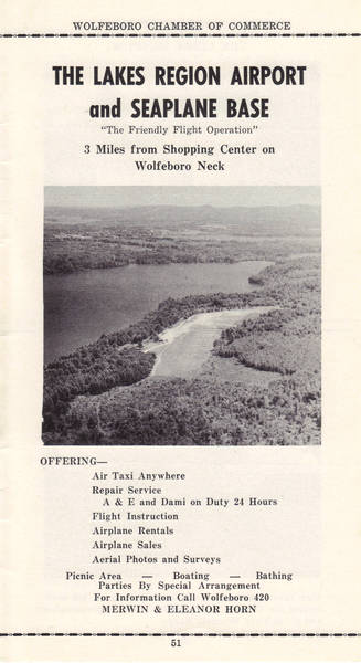
To the best of my knowledge, this is the last publication of The Lakes Region Airpark, dating from about 1997:
|
|
|
|
| The Following User Says Thank You to ApS For This Useful Post: | ||
Little Barndoor 1960 (08-05-2012) | ||
|
09-15-2012, 09:18 PM
|
#32 |
|
Senior Member
Join Date: Jan 2005
Location: Florida (Sebring & Keys), Wolfeboro
Posts: 5,943
Thanks: 2,218
Thanked 779 Times in 555 Posts
|
An all-white Stinson Gull-Wing that was identified as such last year, flew over Winter Harbor again yesterday. I immediately telephoned my Dad nearby, and he said he'd just heard it (!)
Seen from above or below, it presents a unique and interesting wing shape, being strongly tapered.  Never having seen one before, it was like a page taken from "yesteryear", when Stinson Gull-Wings were everywhere. (75 years ago). Dr. Libby had a Stinson Gull-Wing on floats, and before the war, frequently landed on Mirror Lakeadjacent to the Wolfeboro museum that bears his name. But this saga continues, a rare 1937 Stinson Gull-Wing had crashed into a berm on a field in May, 2012just over the border in Maine. This is a large aircraft, and these are expensive collector-items nowadays... Was yesterday's sighting the same "crashed" aircraftbut restored...?
|
|
|
|
|
10-14-2012, 03:13 PM
|
#33 |
|
Junior Member
Join Date: Apr 2004
Location: Wolfeboro
Posts: 6
Thanks: 0
Thanked 7 Times in 3 Posts
|
I remember when I was maybe a teenager or younger, a plane in the trees
by Frankum's area. Anyone remember any other crashes? I know a lot of Wolfeboro's folks never would have the experience to fly, if it was not for Merwin. A friend a mine, did barter with him |
|
|
|
|
12-20-2012, 06:34 AM
|
#34 | ||
|
Senior Member
Join Date: Jan 2005
Location: Florida (Sebring & Keys), Wolfeboro
Posts: 5,943
Thanks: 2,218
Thanked 779 Times in 555 Posts
|
Quote:
 Even then, Merwin hosted "$10 rides" in behalf of the American Cancer Society. Several local pilots offered their aircraft in support of ACS rides, which ended about 1994. Even then, Merwin hosted "$10 rides" in behalf of the American Cancer Society. Several local pilots offered their aircraft in support of ACS rides, which ended about 1994.One local builder built several of the homes in the 40s and 50s, and those same homesunmodifiedare still around.  If you'd been anchored in Johnson's Cove, that particular aircraft would have been flying directly overhead! Until the developer's "terraforming" of 2006, you would have seen fragments of windshield from that crash. The crash-scene debris was extensive, as the plane was supported high in the trees. Gasoline was leaking down from the plane while rescuers dislodged the pilot's feet from the pedals. (I'm not sure if that aircraft was a Beechcraft Sundowner, but it was definitely a low-wing aircraft). There were other crashesone of which I witnessed myself. By the time I'd arrived, the Navion aircraft had settled into a small growth of young birch trees, and the unhurt occupants merely exited by stepping out onto the wingsas they normally would have. This is a pair of Navions:  Of course, there was still six feet left to reach solid earth! There's much more to this Navion crash story. A cold air mass was blamed for the end of Merwin's own Taylorcraft (on floats) which crashed into a pine treeflown by a pilot-instructor! BTW: Merwin had a cottage industry in modifications of floats of aircraft. From this site:  "Your" crash scene would have been about ¼-mile from the east end of the runway. (At the bottom of the picture). More... Quote:
 "Lakes Region Airpark" details: |
||
|
|
|
| The Following User Says Thank You to ApS For This Useful Post: | ||
Senter Cove Guy (12-20-2012) | ||
|
12-20-2012, 08:37 AM
|
#35 |
|
Senior Member
Join Date: Jan 2006
Posts: 6,767
Thanks: 754
Thanked 1,462 Times in 1,018 Posts
|
I remember going on those Cancer Society rides. As kids, we paid a penny a pound.
|
|
|
|
|
07-10-2013, 08:39 PM
|
#36 |
|
Senior Member
Join Date: Jan 2005
Location: Florida (Sebring & Keys), Wolfeboro
Posts: 5,943
Thanks: 2,218
Thanked 779 Times in 555 Posts
|
Viewing the Lake Winnipesaukee woodcuts available now, I caught a glimpse of an interesting feature that extended far out from the Horn's floatplane dock, gas pump, and ramps.
The "spike" of shallows was undoubtedly the result of repeated driveway wash-outs. The driveway was about 75-feet wide, and led down steeply to the ramps. Over the half-century of operation, many truckloads of driveway contractor-fill replaced each washout, which resulted in that "fan" of dirt out into the lake. Those shallows have been there for ages and the area is very rich in freshwater mussels. I remember one there clamped onto my trolled orange and black Flattie plug, which took the Flattie's strongly-vibrating motions away--alerting me to "the bite". Maybe, he thought he'd caught me?
|
|
|
|
|
10-03-2013, 01:55 PM
|
#37 |
|
Senior Member
Join Date: Jan 2005
Location: Florida (Sebring & Keys), Wolfeboro
Posts: 5,943
Thanks: 2,218
Thanked 779 Times in 555 Posts
|
A new pamphlet available at the Wolfeboro Library shows a number of B&W photographs of Wolfeboro Neck. As of this date, the Library has run out of the pamphlets; however, I believe our ever-ready membership will prove to be resourceful in locating other copies.
I just learned the following pamphlet photos were assembled by member Camp Guy and camp-friends, and that the pamphlet photos can be posted freely here. _________________________ The first is an assemblage of airport-friendly gals--including the earliest photo I've ever seen of Eleanor Horn. (2nd from left). The floatplane is undoubtedly the same Taylorcraft floatplane that kicked around Wolfeboro Neck for four decades. I'll have to check on the Internet history of NC 29188. Hmmm... Didn't it end up at the top of a nearby White Pine tree with a flight-instructor at the controls? I do recall the pilot's name, but why "visit" that particular piece of information?  Second-up, an early aircraft-engine Iceboat "invention" made by Merwin and a friend. The photo includes both friends, but I'd have to guess that Merwin (Left ?) looked very different in the 1930s. The third photo taken from the above pamphlet is of a Kitty Hawk floatplane discussed elsewhere at this forum; however, the site in the picture is not the "Lakes Region Airpark" at Wolfeboro.
|
|
|
|
|
11-14-2013, 10:00 AM
|
#38 |
|
Junior Member
Join Date: Nov 2013
Posts: 1
Thanks: 0
Thanked 0 Times in 0 Posts
|
Looking at the pictures posted of Merwin Horn - this was published in America's First Resort in May 2013. If you need additional copies, I can get them to you - as I am the publisher.
|
|
|
|
|
11-14-2013, 01:07 PM
|
#39 |
|
Senior Member

Join Date: Jul 2005
Location: Berlin, Ma / Gilford
Posts: 1,934
Thanks: 450
Thanked 605 Times in 341 Posts
|
Very Very interesting reading ... I missed this thread initially.
Am I to construe that the Marriot Family still owns the property ? and has anything been done there of recent? As we only get to see that area by water, I do not recall any significant development or construction.
__________________
A bad day on the Big Lake (although I've never had one) - Still beats a day at the office!! |
|
|
|
|
08-08-2015, 10:00 PM
|
#40 | ||
|
Senior Member
Join Date: Jan 2005
Location: Florida (Sebring & Keys), Wolfeboro
Posts: 5,943
Thanks: 2,218
Thanked 779 Times in 555 Posts
|
Quote:
 By your user-nameexcelsior007I'd guess you know a lot about Wolfeboro history. Have you access to the video of the l-o-n-g interview I made of Merwin Horn one year before he died? Quote:
Merwin would have sold a kidney to buy the land and take down those huge pine trees that obstructed the approach to the runway. As the airport flourished, they'd grown fast enough to eventually become a hazard for an aircraft's approach to the runway. Cool and shaded air caused aircraft on final approach to drop precipitously. As recently as ten years ago, you could find broken aircraft canopy fragments, aluminum straps, seat belts, and other scattered parts. As I recall, some painted items remaining in the area were blue and white in color. That land east beyond Johnson's Cove includes some interesting structures, including Brad Frankum's 1950s vintage summer lakefront home"Shadowbrook". (Now being rented-out by the Marriotts). Old Fords figured prominently on Wolfeboro's many dirt roads. I'd purchased Brad Frankum's Model A Ford, which had been painted white and red. We'd previously borrowed Merwin Horn's 1934 Ford Model A dually truck to clear our lot of tree debris.On the main area of the former airport runway, no additional building has been started, and I'm told that none is expected any time soon; however, they've left the former owner's many underground electrical service structures in place. The hanger from the early 1970s is being used for maintenance of equipment and storage: it's still a busy place. Also, to preserve the view towards The Broads, the waterfront property facing The Broads is likely to remain undeveloped indefinitely. The only additional news is that the solitary "model home" elevated high on the property, had its porch "rearranged" by lightning! Just found among my many photographs is the one below, which pictured the lakeside floatplane activity about the time Merwin Horn died in 1997. There are three floatplanes pictured, and one wooden boat. The red object to the right is a standard airport fabric"wind sock", to show the direction of the wind in the immediate area. Built there now is a large McMansion, complete with three docks and three huge fireplaces described earlier.  Another piece of trivia: I didn't know it at the time, but Merwin's niece was my Brewster Academy Prom-Date!
|
||
|
|
|
| The Following User Says Thank You to ApS For This Useful Post: | ||
Paular (08-14-2015) | ||
|
02-25-2016, 09:33 PM
|
#41 |
|
Member
Join Date: Sep 2015
Location: NH
Posts: 39
Thanks: 4
Thanked 12 Times in 7 Posts
|
I came across this thread last night and it brought back some nice memories of Lakes Region (8B8)
My uncle owned a place out on Wolfeboro neck. I actually never drove there, but rented cessnas(152 and 172s) and flown in there several times. Today I was flying in the area and ended up following down the entire eastern shore of Winnipesaukee from Moultonboro down to the Baher "resort" - and right over 8B8. Or what used to be From what I could see there is now a house on the Southeastern side and an industrial looking building on the North side. It almost looked like it could've been a hangar - I don't remember one being there though. The only place we saw people out on the ice was Melvin bay - fishing I assume, but no bobhouses. Waved to them. |
|
|
|
| The Following User Says Thank You to DUSTOFF For This Useful Post: | ||
ApS (03-03-2016) | ||
|
02-26-2016, 08:32 AM
|
#42 |
|
Senior Member
Join Date: Jan 2015
Location: Connecticut and Tuftonboro
Posts: 55
Thanks: 116
Thanked 41 Times in 18 Posts
|
Here is a website with info and pictures of old closed NH airports including
Lakes Region: http://www.airfields-freeman.com/NH/...s_NH.htm#lakes |
|
|
|
|
02-26-2016, 08:57 AM
|
#43 | |
|
Senior Member
Join Date: Jan 2006
Posts: 6,767
Thanks: 754
Thanked 1,462 Times in 1,018 Posts
|
Quote:
|
|
|
|
|
|
02-26-2016, 01:50 PM
|
#44 |
|
Senior Member
Join Date: Jun 2005
Location: Exeter NH
Posts: 604
Thanks: 0
Thanked 1,032 Times in 227 Posts
|
That rig looks remarkably like something I found last summer. Viz was bad even at 40 feet so I didn't film it.
I have seen many things in the lake that are strange. Some I could eventually ID, many I could not. This structure/object was one I could not. It was like nothing I had ever seen before. It was heavy wood, with odd angles to the planking, that had both as I recall a horizontal dimension and a vertical dimension up into the water column. It still baffles me. When I saw the picture APS posted it clicked that maybe this is one of these great old machines. If so it would be worth bringing up. I will go back this summer and dive it again, this time filming it. Thanks for the great pictures everyone. My father was a private pilot for almost 40 years-fond memories flying with him all over. |
|
|
|
|
02-27-2016, 07:31 AM
|
#45 | |
|
Senior Member
Join Date: Jan 2005
Location: Florida (Sebring & Keys), Wolfeboro
Posts: 5,943
Thanks: 2,218
Thanked 779 Times in 555 Posts
|
Diver 1111, information on that propeller-driven iceboat would be very much appreciated. Merwin still has family in Wolfeboro and nearby environs, and I'm "hoovering" all I can for this thread.
Quote:
Of course, being a neighbor of Merwin, I should have very few photographs of Merwin Horn. Otherwise healthy, his legs had given out, so he spent his last years close by the Airpark's hanger"hanging out" in the sun. 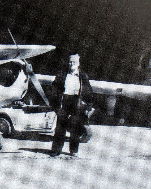 In this undated photo, Merwin (R) is discussing an engine feature to a Civil Air Patrol member. (Name and rank unknown). The Civil Air Patrol was active during and after WWII. Following its heydays, this region's CAP was intermittently active at the Wolfeboro Airpark from the 1950s to the Airpark's dissolution. Until the Airpark was sold, Merwin stored a dark blue school bus close to the workshop. The bus was painted in CAP colors and logo. I saw that same bus in Moultonborough perhaps eight years ago. Where the Civil Air Patrol has gone now is anybody's guess. 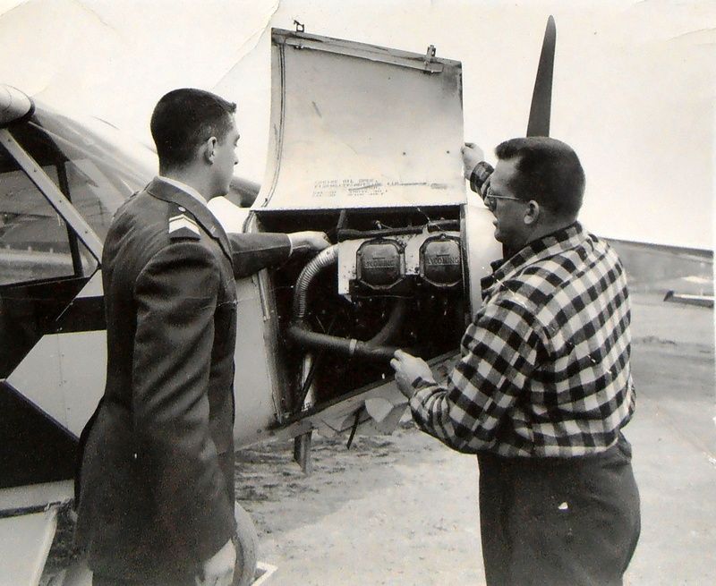 . |
|
|
|
|
|
02-27-2016, 10:59 AM
|
#46 | |
|
Member
Join Date: Sep 2015
Location: NH
Posts: 39
Thanks: 4
Thanked 12 Times in 7 Posts
|
Quote:
|
|
|
|
|
| The Following User Says Thank You to DUSTOFF For This Useful Post: | ||
ApS (09-04-2019) | ||
|
02-29-2016, 08:56 PM
|
#47 |
|
Senior Member
Join Date: Apr 2004
Location: winter harbor
Posts: 200
Thanks: 4
Thanked 33 Times in 18 Posts
|
Did Horn or a relative ever used to live on Keewaydin Road in what is now a yellow house just before the pavement ends?
|
|
|
|
|
03-01-2016, 09:36 AM
|
#48 | |
|
Senior Member
Join Date: Jan 2006
Posts: 6,767
Thanks: 754
Thanked 1,462 Times in 1,018 Posts
|
Quote:
I think his name was Horn. I am thinking they were not relatives though. I could tell you some stories about him! He was scary. Now you have peaked my interest, I am going to try to wake the memory up!!! |
|
|
|
|
|
03-01-2016, 10:44 AM
|
#49 |
|
Senior Member
Join Date: Apr 2004
Location: winter harbor
Posts: 200
Thanks: 4
Thanked 33 Times in 18 Posts
|
The boat in your photo looks like the one we sold to your father many moons ago.
|
|
|
|
|
03-01-2016, 11:01 AM
|
#50 | |
|
Senior Member
Join Date: Jan 2006
Posts: 6,767
Thanks: 754
Thanked 1,462 Times in 1,018 Posts
|
Quote:
Still trying to remember the name of the guy that lived in the yellow house, well, the one I think you are talking about. He also owned the camp down by the water beside Osseo. |
|
|
|
|
|
03-01-2016, 11:06 AM
|
#51 |
|
Senior Member
Join Date: Jan 2006
Posts: 6,767
Thanks: 754
Thanked 1,462 Times in 1,018 Posts
|
I am thinking Wes Horne (with an e)was the Horne that lived in that house. But he was not the guy I was thinking of. He might have owned it before this guy? You now have me very curious. I hate how we forget things!!!
|
|
|
|
|
03-01-2016, 01:45 PM
|
#52 |
|
Senior Member
Join Date: Apr 2004
Location: winter harbor
Posts: 200
Thanks: 4
Thanked 33 Times in 18 Posts
|
Yes. It was Horne with an e. Could have been Russell, Forest, Wesley or Herbert.
|
|
|
|
|
03-01-2016, 02:03 PM
|
#53 | |
|
Senior Member
Join Date: Jan 2006
Posts: 6,767
Thanks: 754
Thanked 1,462 Times in 1,018 Posts
|
Quote:
|
|
|
|
|
|
09-03-2017, 11:35 AM
|
#54 | ||||
|
Senior Member
Join Date: Jan 2005
Location: Florida (Sebring & Keys), Wolfeboro
Posts: 5,943
Thanks: 2,218
Thanked 779 Times in 555 Posts
|
Quote:
Quote:
A little CAP factoid: Quote:
Quote:
Last I heard, a condominium built on the former airport property has fallen into disrepair.  More information on the hanger's copper weathervane formerly located on the Orvis store [airport hanger], and the "2013-news" is, that store is (was) vacant. here. That weathervane isn't intended to be a good replica of the Waco biplanes maintained at White Mountain Airport. If you'd bought tickets to fly The Red Baron at the White Mountain Airport, you'd have bought them from the wife of the Red Baron pilotwho was my Dad. White Mountain Airport had a Blue Waco, too, but don't know if it had a name. Two of the "tourists" flying together over Mt. Washington included John McEnroe and Ilie (Nasty) Nastase.Every pilot loves to fly, and my Dad had it in spades. He "commuted" with his Cessna 180 from Wolfeboro Air Park to White Mountain Airport so he could fly some more! Also below, a portion of a 1984 Granite State News article by local, Jean Batchelder. I haven't seen anything of late by Jean Batchelder, and don't know what a VASI system is, but pretty sure it's gone. Hard to believe that a serviceable dock was replaced in 1984, then replaced again in 1995, then replaced again in 2014 (with three docks), then two docks replaced again last year. I've picked the wrong career! .
__________________
Is it "Common Sense" isn't.
|
||||
|
|
|
|
03-17-2018, 05:50 AM
|
#55 | |
|
Senior Member
Join Date: Jan 2005
Location: Florida (Sebring & Keys), Wolfeboro
Posts: 5,943
Thanks: 2,218
Thanked 779 Times in 555 Posts
|
My family had moved adjacent to the Wolfeboro Airpark 12 years before the below flyover took place. Judging by the below video, no military jet flyover at that altitude has occurred since.
This 1967 flyover occurred above Camp Wyanoke on the shore of Winter Harboradjacent to Carry Beach. While I'd heard of this flyover "over the Internet", I've just received an email with more detailing: Quote:
filmed over Camp Wyanokeperhaps on Super-8 movie filmthe accompanying YouTube video appears here:https://www.youtube.com/watch?v=Sfju...ature=youtu.be The actual flyover begins upon the accompanying song's lyrics, "...when this war is over...". Less than a mile away, the Horns' telephone was ringing off the hook at the Airpark. However, the video shows a jet with a single exhaust, intake, and engineand appears to be a F8U Crusader. This puts the above quote into the category of "Mists of Memory and Time". "Writer's License"? To be fair, they are both U.S. Navy jets. A video comparing the two fighters in a "friendly dogfight": http://www.dailymotion.com/video/x47vsla .
__________________
Is it "Common Sense" isn't.
|
|
|
|
|
|
03-17-2018, 07:28 AM
|
#56 |
|
Senior Member
|
So, what's that song ....... sounds like the Kingston Trio ..... is like the last verse from 'Head'n for the Hills' sung by the Limelighters in about 1963 ... google knows everything.
__________________
... down and out, liv'n that Walmart side of the lake! |
|
|
|
|
08-10-2018, 09:59 AM
|
#57 | |
|
Senior Member
Join Date: Jan 2005
Location: Florida (Sebring & Keys), Wolfeboro
Posts: 5,943
Thanks: 2,218
Thanked 779 Times in 555 Posts
|
Quote:
Out West (NM), their Cessna Skylane has a very distinctive appearance: 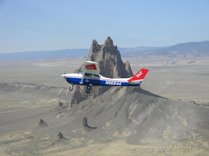 .
__________________
Is it "Common Sense" isn't.
|
|
|
|
|
|
09-04-2019, 10:05 PM
|
#58 | |
|
Senior Member
Join Date: Jan 2005
Location: Florida (Sebring & Keys), Wolfeboro
Posts: 5,943
Thanks: 2,218
Thanked 779 Times in 555 Posts
|
A longtime commercial tenant at The Lakes Region Airpark was Eastern Topographics aircraft. In addition to covering New Hampshire's many geographical features, they sell aerial photographs of Lakes Region properties.
Their office abuts West Lake Restaurant north of Wolfeboro. In 2016, I'd contacted them for details of their relationship with Merwin Hornowner/operator of The Lakes Region Airpark. Eastern Topographics Office Manager: Quote:
Since then, the staff has kindly provided a photograph for this thread, taken about 1995.
|
|
|
|
|
|
04-14-2022, 12:45 PM
|
#59 |
|
Moderator

|
As an almost daily user of MS Flight Simulator 2020 I was happy to find that someone had created detailed scenery of the Wolfeboro airport including the water runways. After flying in and out a few times I now know better how the field was positioned along the lake and what it looked like.
This is free scenery for MSFS 2020 users and easy to install. Thanks to "FlyingsCool" for creating it. The README file even contains a link to this thread (started in 2005!) for more information.: https://flightsim.to/file/1808/lakes...o-nh-lake-winn |
|
|
|
|
12-26-2023, 07:12 AM
|
#60 | |
|
Senior Member
Join Date: Jan 2005
Location: Florida (Sebring & Keys), Wolfeboro
Posts: 5,943
Thanks: 2,218
Thanked 779 Times in 555 Posts
|
Quote:
https://dcnewsroom.blogspot.com/2023...ix-cessna.html |
|
|
|
|
|
01-01-2024, 08:23 AM
|
#61 |
|
Senior Member

Join Date: Apr 2004
Location: Moultonboro, NH
Posts: 2,935
Thanks: 478
Thanked 694 Times in 389 Posts
|
Great thread Aps. Concerning the CAP, there is a very active wing right at Laconia Airport. They have at least one newer looking Cessna 182 tied down on the main ramp, right next to the Skybright hangar. It flies regularly in the area, you can see it from the terminal parking lot when it is not flying. They also have programs for youth. A few months ago I met a young man there who was going with the CAP a bowling outing. Here is their website, they also have a web page.
http://hawksquadron.nhcapcadets.org/...PFnOQl5ss1rP-E |
|
|
|
|
06-01-2024, 05:57 PM
|
#62 |
|
Senior Member
Join Date: Jan 2005
Location: Florida (Sebring & Keys), Wolfeboro
Posts: 5,943
Thanks: 2,218
Thanked 779 Times in 555 Posts
|
The Civil Air Patrol wasn't the only civilian force to join in active scouting for U-boats off US' eastern shorelines:
https://youtu.be/ygVYat8DYuU?si=AWKECPqPOQc1WKFO |
|
|
|
|
| Bookmarks |
|
|


 Linear Mode

