

|
|
|
|
|
|||||||
| Home | Forums | Gallery | Webcams | Blogs | YouTube Channel | Classifieds | Register | FAQ | Members List | Donate | Today's Posts | Search |
 |
|
|
Thread Tools | Display Modes |
 06-19-2009, 10:21 AM
|
#1 |
|
Senior Member

Join Date: Nov 2003
Location: Central NH
Posts: 5,253
Blog Entries: 1
Thanks: 1,455
Thanked 1,357 Times in 476 Posts
|
Last night Rattlesnake Guy and I were trying to remember where to find the links for lake levels and I thought that I would re-share them with the Forum.
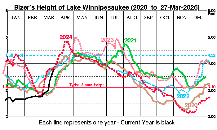 BIZER's Surface level of Lake Winnipesaukee  New Hampshire Department of Environmental Services Lake Winnipesaukee Year-to-Date Graph and Data I think it's time to shut off the rain and let summer begin!!! |

|

|
|
06-22-2009, 06:58 PM
|
#2 |
|
Senior Member

Join Date: Sep 2007
Posts: 74
Thanks: 83
Thanked 16 Times in 9 Posts
|
Does anyone know if anything is being done to lower the level of the Lake?
|
|
|
|
|
06-22-2009, 07:05 PM
|
#3 |
|
Senior Member

Join Date: Apr 2004
Location: North Shore, MA
Posts: 1,358
Thanks: 996
Thanked 314 Times in 164 Posts
|
The discharge at the Lakeport Dam is now close to 1,600 cubic feet per second. That seems to be holding the lake level steady at 504.56 It can be opened more, but the actions so far are working. That is good news.
As long as we do not get a 2" or 3" rainfall in the next week to ten days, we should be fine. A heavy rain in the next week will get us to 505'+ which usually brings some expanded "no wake" action. Here is a link to some detailed information: http://www2.des.state.nh.us/RTi_Home/winni.asp R2B Last edited by Resident 2B; 06-23-2009 at 11:56 AM. Reason: Adding link to lake levels and dam discharge |
|
|
|
|
06-23-2009, 07:23 AM
|
#5 | |
|
Senior Member

Join Date: Apr 2008
Location: Southboro, MA
Posts: 579
Thanks: 75
Thanked 384 Times in 170 Posts
|
Quote:
|
|
|
|
|
| Sponsored Links |
|
|
|
06-23-2009, 08:34 AM
|
#6 |
|
Senior Member
|
To see the fast running river up close, take a visit to the new Laconia City Hall kayak launch ramp, located on the Winnipesaukee River just 50 yards below the Avery Dam. Was there last evening and guaging the water speed is difficult....maybe a runoff speed of 12-mph. At the kayak launch the Winnipesaukee River is aprox 75 feet wide, and between two and eight feet deep (guess estimate) which seems small for huge Lake Winnipesaukee.
Ordinarily, a water speed of 12-mph would create white water rapids, but probably all rock obstructions have been removed from the river bed so's to create a smooth outflow. A natural river would have an uneven bottom with large rocks that create white water rapids with a 12-mph current, but the Winnipesaukee River has been scraped and sanded by local industrial use since the first dam was built in 1822. Both embankments are built up with large, old granite blocks. For a good fast 600(?) yard ride down the Winnipesaukee River, and into Lake Winnisquam, go hit the new Laconia City Hall kayak launch. It is all of 30 feet from a Laconia parking space, and there's no parking meters. Here's a plan....spot one car down stream at the Lake Winnisquam (on the Winnipesaukee River) state motorboat launch ramp facility, behind Bolia Gourell Lumber, and run the river the 600 or so yards from the city hall kayak launch to the no-charge, state boat launch dock and parking facility. Walking the distance is about 15 minutes, and it goes right past the new Laconia police station. With this fast and smooth water, it could be worth the drive to KAYAK LACONIA  ! !KAYAK LACONIA ...... Warning - personal water safety issues should be considered because it is now a fast moving and cold, 66 degree river that passes under about five different, low bridges. The kayak launch ramp includes a sturdy, high, lockable gate, which when locked, would pretty effectively close the launch ramp.
__________________
 .... Banned for life from local thrift store! .... Banned for life from local thrift store!
Last edited by fatlazyless; 06-23-2009 at 03:27 PM. |
|
|
|
|
06-23-2009, 12:01 PM
|
#7 |
|
Senior Member
Join Date: Apr 2004
Location: North Shore, MA
Posts: 1,358
Thanks: 996
Thanked 314 Times in 164 Posts
|
The Lakeport Dam is now dumping water at the rate of 1,700+ CFS. This is an increase of about 100 CFS and the increased flow occurred between 8 and 9 this morning.
R2B |
|
|
|
|
06-23-2009, 04:01 PM
|
#8 |
|
Senior Member

Join Date: Apr 2004
Location: NJ
Posts: 535
Thanks: 86
Thanked 47 Times in 27 Posts
|
After reading all the posts, I checked the Downings webcam in Alton Bay. The dock in just shy of being underwater. The last time I saw the lake this high was back in 1998, I think, when most docks were underwater including the one at the Boat Gas at the end of Alton Bay. I remember standing on the neighbors dock, which was just under the water, while my husband took a picture. It looked like I was walking on water.
Don't like the prospect of another summer of the whole lake being a no-wake zone, though. nj2nh
__________________

|
|
|
|
|
06-23-2009, 04:15 PM
|
#9 |
|
Senior Member
Join Date: Apr 2004
Location: North Shore, MA
Posts: 1,358
Thanks: 996
Thanked 314 Times in 164 Posts
|
nj2nh,
It is not as bad as you are thinking, actually a foot lower than it was in 1998. The lake level was higher than it is now in 2005, 2006, 2007 and 2008. Although we need to be concerned, I believe the lake level is high, but well under control. R2B |
|
|
|
|
06-23-2009, 04:57 PM
|
#10 |
|
Senior Member

Join Date: Jul 2002
Location: Pennsyltuckey, Tuftonboro, Moultonborough
Posts: 1,510
Thanks: 387
Thanked 234 Times in 128 Posts
|
No -- check the Bizer graph -- it's just about where it was in 2006, perhaps higher now, and definitely higher than it was at this time in all the other years listed, except for 1998 and 1984.
In late May of 1984, I watched the Lake slowly rise and eventually wash right over our dock. Eventually, it stopped a good 2 inches above dock level. We were very lucky that there were no big winds during that time. Tying the boat was a real challenge.
__________________
"When I die, please don't let my wife sell my dive gear for what I told her I paid for it." |
|
|
|
|
06-29-2009, 04:38 PM
|
#11 |
|
Senior Member
|
Today's June 29 www.citizen.com reports the Laconia Fire Dept rescued a young woman from the strong current in the Winnipesaukee River, this morning. Apparently, the Fire Dept launched their rigid inflatable outboard boat from the new kayak launch ramp, recently opened close to Laconia City Hall and got out at the Winnisquam state boat launch dock & ramps, about 600 fast yards, down stream, below the Boulia Gourrel Lumber.
The second photo shows the new very well constructed concrete and iron railing kayak launch ramp in the background. So, if the fire department can fit under the five or so low bridges with a rigid inflatable boat then doing it in a kayak is doable. There is probably no white water as all natural rock obstructions have been removed from the river, even though the current could be flowing fast at 12-mph or so, which is deceptive and possibly cold & dangerous if your kayak or canoe gets caught up against a bridge support.
__________________
.... Banned for life from local thrift store!
|
|
|
|
|
07-02-2009, 09:08 AM
|
#12 |
|
Senior Member
|
How fast is the current moving in the Winnipesaukee River? Well, last evening down by the new kayak ramp, I watched a 12" long musk rat try to swim upstream against the current. At first I thought it was a beaver because it was so big, except it had a thin pointy tail so it must have been a rat. Any, as it proceeded upstream around a corner angle of the masonry embankment wall, it couldn't negotiate the current so it scrambled for the concrete kayak ramp and opted for a walk through the park, as it headed upstream towards the dam. Every thirty seconds it would stop, get up on its hind legs, and take a good look around.
The security gate to the ramp is not locked, so anyone looking for a real good challenge to go practice ferrying back & forth, across the Winnipesaukee River.... down at the Laconia City Hall kayak & canoe launch....if the sun ever comes out again..... ....it could be worth a visit...
__________________
.... Banned for life from local thrift store!
|
|
|
|
|
07-02-2009, 11:37 AM
|
#13 |
|
Senior Member

|
On Tuesday I took a ride on the boat with the kids. The Channel was humming. I put the boat in Neutral and the GPS read 4.5 MPH. In gear the boat was traveling roughly 7.5 MPH. It was pretty fun! The kayakers in the channel were having a blast.
FYI, the gauge on the bridge read that the lake was at least two inches below full. That was before all this crazy rain today! |
|
|
|
|
07-05-2009, 12:49 PM
|
#14 |
|
Senior Member

Join Date: Apr 2004
Location: phoenix and moultonboro
Posts: 1,592
Thanks: 65
Thanked 288 Times in 204 Posts
|
water temperature 5 degrees colder than last year on the same day
__________________
it's tough to make predictions specially about the future |
|
|
|
|
07-07-2009, 05:48 PM
|
#15 |
|
Senior Member
Join Date: Jun 2007
Posts: 2,129
Thanks: 380
Thanked 1,016 Times in 345 Posts
|
I noticed while driving home tonight that the water is getting up pretty high at the Tuftonboro town docks. Another 6" and they will be underwater. Also, a little further down at the mini-beach near Chandler Street, that is almost all under water now....

|
|
|
|
|
| Bookmarks |
|
|


 Linear Mode

