

|
|
|
|
|
|||||||
| Home | Forums | Gallery | Webcams | Blogs | YouTube Channel | Classifieds | Register | FAQ | Members List | Donate | Today's Posts | Search |
 |
|
|
Thread Tools | Display Modes |
 09-08-2009, 06:22 PM
|
#1 |
|
Junior Member
Join Date: Sep 2009
Posts: 6
Thanks: 0
Thanked 20 Times in 3 Posts
|
Well as of 9/6/09 they have the lake down almost two feet from "Full Lake"......now I can't get my boat off the lift and out of my boathouse - will now have to take my boat out of the water later this week......ridiculous!! This is pathetic that they have to lower the lake this much so early - why can't they wait til October? Why does this happen?
My neighbors are fighting the same battle. Any insight is appreciated! |

|

|
|
09-08-2009, 06:33 PM
|
#2 |
|
Senior Member

Join Date: Apr 2004
Location: Lakes Region
Posts: 819
Thanks: 42
Thanked 185 Times in 116 Posts
|
The level for this time of year is almost perfectly "normal" and right in the center of the plots over the last 20 years.. so the dam operators must believe that this is the proper level for the first week in Sept. It would seem that "normal" is too low for what you would like - but every year they are going to shoot for this same level for early September...
http://www.bizer.com/bztnews.htm |
|
|
|
|
09-08-2009, 06:43 PM
|
#3 |
|
Senior Member
Join Date: Apr 2007
Posts: 93
Thanks: 12
Thanked 33 Times in 12 Posts
|
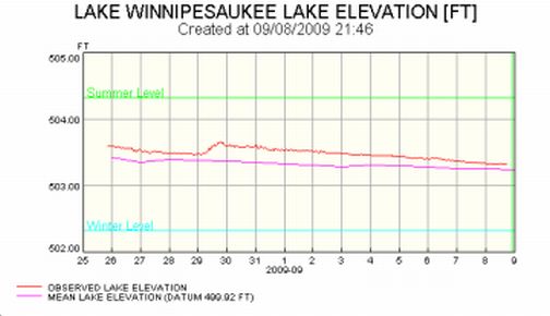
Actually, according to the attached link, the lake is 1 foot below full, not 2 feet. "Full" is 504.32 ft if I remember correctly. Today at 2 pm it was at 503.31'. As stated above, this seems about normal for this time of year.
http://www2.des.state.nh.us/rti_data/wein3_TABLE.HTML |
|
|
|
|
09-08-2009, 08:02 PM
|
#4 |
|
Senior Member

Join Date: Jul 2002
Location: Pennsyltuckey, Tuftonboro, Moultonborough
Posts: 1,510
Thanks: 387
Thanked 234 Times in 128 Posts
|
Nah -- it's pretty average for this time of year, after being a bit higher than usual for much of the mid-summer.
How's that cyanobacteria action? (SKEEVED)
__________________
"When I die, please don't let my wife sell my dive gear for what I told her I paid for it." |
|
|
|
|
09-08-2009, 08:24 PM
|
#5 |
|
Senior Member
Join Date: Jun 2009
Posts: 68
Thanks: 17
Thanked 44 Times in 15 Posts
|
Whether the level is "average," "normal," or "right for this time of year," it is too low for me to get my boat out without walking it away from the dock and out 30' from shore. I wish they would leave it up about a foot from where it is now, but so be it. I'll deal with it and pray it rains and snows all winter.
|
|
|
|
| Sponsored Links |
|
|
|
09-08-2009, 08:35 PM
|
#6 |
|
Senior Member

Join Date: Aug 2004
Location: Moultonborough & CT
Posts: 2,550
Thanks: 1,072
Thanked 672 Times in 369 Posts
|
Amazing! We now have mechanized methods of lifting boats at their dock but of course they must be preset to a certain level to "accept" the boat and then allow the boat to be "free". Unfortunately the "lake level" doesn't always cooperate with the "lifters" settings that the boat owner set. Deal with it!

|
|
|
|
|
09-08-2009, 10:00 PM
|
#7 | |
|
Senior Member

Join Date: Apr 2004
Location: North Reading, MA and South Down Shores
Posts: 858
Thanks: 58
Thanked 183 Times in 114 Posts
|
Quote:
Jetskier 
|
|
|
|
|
|
09-08-2009, 10:46 PM
|
#8 |
|
Senior Member
Join Date: Mar 2008
Location: Bear Island/Merrimack
Posts: 807
Thanks: 58
Thanked 203 Times in 130 Posts
|
We put our post dock in when the water was at its highest with the bottom of the dock just above the water level. The water level is now about a foot lower which is normal for this time of year. We just have to make sure to trim the motor up while at the dock. If we had a permanent dock it would be 10 feet shorter and I'd have a bigger problem than just timming up the motor.
|
|
|
|
|
09-08-2009, 10:47 PM
|
#9 |
|
Senior Member
Join Date: Mar 2009
Location: Laconia NH
Posts: 130
Thanks: 25
Thanked 15 Times in 11 Posts
|
only proves that marinas/boat yards will be busy because people will be hitting things when the water is low. winter work here we come...
 LOL LOL sorry but thats the way it is when the water level goes down. good luck on the lake
__________________
Marine Technician - Learning Something New Every Day PM with any questions about marine repair |
|
|
|
|
09-08-2009, 10:56 PM
|
#10 | |
|
Senior Member
Join Date: Feb 2006
Location: I'm right here!
Posts: 1,153
Thanks: 9
Thanked 102 Times in 37 Posts
|
Quote:
|
|
|
|
|
|
09-08-2009, 10:57 PM
|
#11 |
|
Senior Member
Join Date: Jan 2003
Location: Alton Bay
Posts: 5,616
Blog Entries: 2
Thanks: 2,483
Thanked 1,988 Times in 1,088 Posts
|
Here is DES Chart, and if I read it right, we are above the mean level for this time of year.
__________________
I Live Here... I am always UPTHESAUKEE !!!! |
|
|
|
|
09-08-2009, 11:01 PM
|
#12 |
|
Senior Member
Join Date: Jan 2005
Posts: 130
Thanks: 70
Thanked 33 Times in 25 Posts
|
The lake has been lowered at a rate approaching and exceeding 1000 cfs over the last few weeks to reach this "normal level".
What is so critical about lowering the level one foot by Labor Day? Maybe, the dam operator or operators, who maintained the lake level at boater friendly levels most of the season, can explain. Would an October 1 date work for the lower level? It certainly would extend the boating season, and help out the local economy. Thanks in advance. |
|
|
|
|
09-08-2009, 11:20 PM
|
#13 |
|
Senior Member

Join Date: Apr 2004
Posts: 518
Thanks: 19
Thanked 62 Times in 15 Posts
|
Husband was just bellyachin' about the same thing over the weekend! I think they should wait a few more weeks too.....
|
|
|
|
|
09-09-2009, 01:08 AM
|
#14 |
|
Senior Member
Join Date: Jul 2009
Location: South Down since 2009.
Posts: 102
Thanks: 2
Thanked 34 Times in 25 Posts
|
Take a look at Smith Mountain Lake in Bedford / Franklin counties, Virginia.
This is 'Lake Winni, south'. Remember the Bill Murray / Richard Dreyfuss 1991 movie, 'What About Bob'? Takes place on Lake Winni, but actually filmed at SML. I've spent the last 8 summers there. It's a pumped storage hydro power project, build and run by the electric power company. Their permit requires a certain water flow downstream, even if drought conditions result in less water entering the lake. So in the southwest Virginia droughts of 2007 and 2008 the levels dropped by the end of the summer (into October, summer lasts longer there!) 3-4 feet! Had to set the boat lift on the bottom to get the boat off. And hope the level didn't drop too much while we were out. And when there is demand for hydro power the level can drop a foot during the day! (HOT July weekends, 90+, create huge electric demands). The pumped storage part refills the lake overnight, so Sunday AM the level is almost back to the Saturday AM level. So a day-to-day fluctuation of a foot or more is common! See this link to the water levels: http://www.smithmountainlakelevel.com/SMLLevelWeb.exe Change the first date to 2006 and see how it dropped 3-4 feet from full pond in past years. 2009 has been kinder. Then set the dates for say Sept 5 - 9, and see how it fluctuates up to a foot in one day. |
|
|
|
|
09-09-2009, 04:09 AM
|
#15 | |
|
Senior Member

Join Date: Jan 2005
Location: Florida (Sebring & Keys), Wolfeboro
Posts: 6,028
Thanks: 2,285
Thanked 789 Times in 564 Posts
|
Quote:
 
|
|
|
|
|
|
09-09-2009, 06:13 AM
|
#16 | |
|
Senior Member
Join Date: Aug 2002
Posts: 498
Thanks: 62
Thanked 71 Times in 32 Posts
|
Quote:
|
|
|
|
|
|
09-09-2009, 07:43 AM
|
#17 |
|
Senior Member
Join Date: Apr 2004
Location: Exeter, NH or @ WCYC on weekends
Posts: 250
Thanks: 7
Thanked 46 Times in 28 Posts
|
After watching the lake level drop so much in the past couple of weeks, I decided to have my boat pulled a week early this year. I weight 18,000 lbs and draft 5 feet and we have a 30 ton crane at the club which can lift me easily at short distances. When I came into our usual lifting spot I ran a ground about five feet out, the boys at the club struggle and struggled to lift the boat and at one point had the rear outriggers completely off the ground. They had to re-set the crane three times and drag the boat over the bottom until they got it close enough to lift. That was five hours for three men to to get one boat out.
We have been hauling this boat out in the same spot, with the same equipment for ten years now and never had as much trouble as we had yesterday. So, don't tell me the lake is at it's normal depth... Had I known it was going to be this much hassle I would have had it hauled two weeks ago. BTW: They have two more big boats like mine to get out, but the owner want to stay in a couple more weeks for some fine fall sailing... If we don't get a major storm in the next few weeks it looks like they be wintering over in the lake again this year. |
|
|
|
|
09-09-2009, 07:55 AM
|
#18 |
|
Senior Member
Join Date: May 2009
Location: Gilford
Posts: 561
Thanks: 644
Thanked 178 Times in 96 Posts
|
Totally agree that the lake is way too low. Likely, that's a good part of the reason why we still have a bad bacteria problem of GLOEOTRICHIA in our cove, so bad that we won't go swimming. I kayaked way out almost to Rattlesnake Island and still saw it floating on top of and in the water. Nasty stuff and, according to the state, toxic. Whoever is responsible for lowering the lake this much should explain.
|
|
|
|
|
09-09-2009, 09:50 AM
|
#19 |
|
Senior Member
Join Date: Aug 2002
Posts: 498
Thanks: 62
Thanked 71 Times in 32 Posts
|
Compared to a 27 year average, the lake level is almost exactly at the average for this time of year.
http://des.nh.gov/organization/divis.../graph2009.jpg |
|
|
|
|
09-09-2009, 10:07 AM
|
#20 | |
|
Senior Member
Join Date: Jul 2006
Location: Moultonboro
Posts: 95
Thanks: 0
Thanked 16 Times in 6 Posts
|
Quote:
As so many posters have already pointed out, the lake level is actually normal (or slightly above!) for this time of year. And if you're looking for someone to blame for the high bacteria in your area, forget the lake level... start with all your neighbors who clear cut their lots to the water's edge. |
|
|
|
|
|
09-09-2009, 10:09 AM
|
#21 |
|
Senior Member
Join Date: Jan 2005
Location: Hollis NH/Laconia
Posts: 132
Thanks: 62
Thanked 17 Times in 12 Posts
|
we are already bottoming out at our marina in the first week of sept when we come and go. the lake is too low no matter what the spreed sheets show......
|
|
|
|
|
09-09-2009, 10:15 AM
|
#22 |
|
Senior Member

Join Date: Apr 2004
Location: formerly Winter Harbor, still Wolfeboro
Posts: 1,224
Thanks: 317
Thanked 560 Times in 310 Posts
|
Okay, how about this for an answer: Maybe there have been changes to the bottom which result in an apparent lowering of the top because there is less water.
If I am correct, the standard Full Lake of 504.32 is calculated "as over mean sea level" at the top of the Lake, not necessarily a depth chart. If, for some reason, there were changes to the bottom, ie., sandbars, etc., near the shoreline, this would have the effect of creating less water which would look like the Lake was lower, but not actually the case. I lived on the Lake for a number of summers, and there was a small brook that emptied into the Lake about 10 feet from my dock, and, when I would check the depth with a stick gauge I found the depth to be less after a heavy run off event. Now, maybe some hydrology/geology scientists can chime in and straighten me out. |
|
|
|
|
09-09-2009, 10:54 AM
|
#23 |
|
Senior Member

Join Date: May 2006
Location: Texas, Lake Ray Hubbard and NH, Long Island Winnipesaukee
Posts: 2,970
Thanks: 1,064
Thanked 912 Times in 539 Posts
|
So everyone is concerned about the lake level which when measured by DES is currently 1' below full lake. The lake has always been at this level this time of year. I don't understand why this seems to be such a shocking revelation. Now do I need to remind you at this point last year we where almost 4 inches lower then we are right now.
The DES information is here: http://www2.des.state.nh.us/RTi%5FHome/winni.asp I also looked at the DES website and saw that just before the weekend they throttle back the output at the dam. Which means right now they are trying to find the balance that will keep the lake at the current level. This means, that when we get some more rain the lake will rise proportionally. If you have been around the lake for any amount of time you will realize that this is normal lake level. So trim your motor up and proceed to your docks a little more cautiously. As for people with boat lifts. Here is your problem, you but you boat lift in assuming full lake. This is not a good practice, you should install a boat lift assuming low lake, and make sure the lift has enough reach to get the boat out of the water at full lake. In short to think that you can put a lift in and have it always work is ridiculous.......you have to plan for it, and if it is not a permanent lift on pylings plan on moving it once a year to keep it in deep enough water.
__________________
Life is about how much time you can spend relaxing... I do it on an island that isn't really an island..... |
|
|
|
|
09-09-2009, 12:55 PM
|
#24 |
|
Senior Member

Join Date: Apr 2004
Posts: 606
Thanks: 304
Thanked 430 Times in 142 Posts
|
With the damkeeper's ability to control the level of the lake, it just seems unnecessary to draw down the lake so early in September. I'd rather see them wait until after Columbus Day to draw it down to below full lake. It seems there's plenty of time to get it to an appropriate level for the fall/winter/next spring.
__________________
Lake Winni - The only place I want to be during the summer. 
|
|
|
|
|
09-09-2009, 03:01 PM
|
#25 | |
|
Senior Member
Join Date: May 2006
Location: Texas, Lake Ray Hubbard and NH, Long Island Winnipesaukee
Posts: 2,970
Thanks: 1,064
Thanked 912 Times in 539 Posts
|
Quote:
If People really want to see this change they should start asking DES questions.
__________________
Life is about how much time you can spend relaxing... I do it on an island that isn't really an island..... |
|
|
|
|
|
09-09-2009, 03:23 PM
|
#26 | |
|
Senior Member
Join Date: Jul 2009
Location: exeter, nh
Posts: 73
Thanks: 4
Thanked 10 Times in 8 Posts
|
Quote:
If you want to blame somebody for the bacteria, start with the folks with the nice green lawns. I don't see how flushing water out of the bowl would create those kinds of problems. |
|
|
|
|
|
09-09-2009, 11:38 PM
|
#27 |
|
Senior Member

Join Date: Sep 2004
Posts: 1,254
Thanks: 423
Thanked 366 Times in 175 Posts
|
I am puzzled by the "perception" that the lake is low. When I look at the usual tells that I use, it does not give that impression. What does seem different this year is that we spent much more of the year at higher levels. Perhaps it is the recent faster rate of change that makes it seem lower. It is more like when your kid grows 6 inches in one summer, you really notice it. Obviously, this does not explain why people are having trouble with their boats. It would seem they would have this problem every year.
I like it when they keep the lake about 6 inches below full. My dock is happier in the waves and the prop is happier above the bottom. |
|
|
|
|
09-10-2009, 04:22 AM
|
#28 | |
|
Senior Member
Join Date: Jan 2005
Location: Florida (Sebring & Keys), Wolfeboro
Posts: 6,028
Thanks: 2,285
Thanked 789 Times in 564 Posts
|
Quote:
1) The original poster may have only experience with recent early-season levels, which have been higher than historic levels. (Perhaps reflecting a new philosophy on keeping the lake "fuller-earlier"?) 2) I, too, have a brook that has dumped a small "alluvial fan" of sand into the lake. (The below "alluvial fan" example is of Planet Mars terrain).  The sand increased somewhat since an immediate-neighbor's McMansion was built three years ago. I never bothered to measure the depth there since a nearby driveway "major washout event" took place seven years ago. That "event" reduced the boat clearance for everybody along the shore within 200'. I kept my ample depth, while finally getting a sandy beach! The depth at the nearest dock forces renters to raise their boats' drivessomething the previous owners never needed to do with their Century Raven inboard. (That driveway's only "repair" was to add a dozen cubic yards of still more sand!)  In Sum: The original poster (and his neighbors) may only be familiar with the most recent early-season depthsdepths that were incorrectly calculated to provide adequate late-season depth for the boat. (And if it's the original boat). Or recent uphill construction has incidentally raised the bottom closer to the top. 
|
|
|
|
|
|
09-10-2009, 07:11 AM
|
#29 | |
|
Senior Member
Join Date: Jan 2005
Posts: 130
Thanks: 70
Thanked 33 Times in 25 Posts
|
Quote:
Thank you for the NOAA chart showing a peak number of storms by Sept 10 for the 100 years period, but how many of these actually impacted the Lakes Region? While staying at a marina during the mid 90's, I was told by one of the owners that a contract required the release of water from the lake to provide power for hydroelectric generation downstream. This accounted for the lower levels late summer even during drought conditions. Does anyone know if this is part of the reason for the "normal" low water levels this time of year? |
|
|
|
|
|
09-10-2009, 07:31 AM
|
#30 |
|
Senior Member
Join Date: May 2004
Posts: 135
Thanks: 10
Thanked 13 Times in 12 Posts
|
Definitely caused by global warming
|
|
|
|
|
09-10-2009, 10:00 AM
|
#31 | |
|
Senior Member
Join Date: May 2006
Location: Texas, Lake Ray Hubbard and NH, Long Island Winnipesaukee
Posts: 2,970
Thanks: 1,064
Thanked 912 Times in 539 Posts
|
Quote:
__________________
Life is about how much time you can spend relaxing... I do it on an island that isn't really an island..... |
|
|
|
|
|
09-10-2009, 11:35 AM
|
#32 | |
|
Senior Member
Join Date: Aug 2002
Posts: 498
Thanks: 62
Thanked 71 Times in 32 Posts
|
Quote:
June - 3 July - 4 Aug - 10 Sept - 18 Oct - 5 No, the numbers aren't huge, but the peak is in late August into September. Perhaps we should be grateful they don't lower the lake sooner. The lowering of the lake is guided by several factors. Let's give the dam operators the benefit of the doubt that they know what they're doing and acknowledge that it can sometimes be a difficult balancing act. |
|
|
|
|
|
09-10-2009, 11:52 AM
|
#33 |
|
Senior Member
|
Fo an up-close look at the Lake Winnipesaukee outflow take a drive over to the new Walgreen's. Over in Laconia, the now under construction Walgreen's store & pharmacy has a very nice parking lot out in back. New pavement, granite curbs, grass,,,,good design and construction.....and it fronts for maybe 200' directly on the Winnipesaukee River which is the outflow for Lake Winnipesaukee as it outflows toward Lake Winnisquam.
Gazing into the medium slow moving water yesterday there were some small schools of bait fish and sunfish swimming around, across the grassy, sandy bottom. Most of the industrial debris like old pipes and concrete blocks have been removed. An ancient 100-year old rotten wood dock which abuts the Walgreen p-lot still remains. The outflow current looked pretty slow compared to June & July. The Walgreen's Laconia parking lot:: a good spot to drop a fishing line or launch a kayak or fill a prescription. Pssst....keep it quiet! And, right next door to Walgreen's, directly on the Winnipesaukee River, and sharing the same parking lot is the large and over-flowing Salvation Army second-hand store. You could probably buy an old fishing rod & reel in there for two dollars, walk out the door, and catch either a smallie or a salmon in the Winnipesaukee River. Will Walgreen's be selling worms?
__________________
.... Banned for life from local thrift store!
|
|
|
|
|
09-10-2009, 12:43 PM
|
#34 |
|
Senior Member

Join Date: Jul 2002
Location: North Kingstown RI
Posts: 688
Thanks: 143
Thanked 83 Times in 55 Posts
|
Maybe this issue should be addressed by members of the "Lake Owners Association" and they can vote on what the lake level should be on a given day. Perhaps there are people that have purchased recently (within the last 10 years) and they were not given due notice as to what level the lake would be at certain times of the year.
9-10-09 Lake Level 503.26 Full Lake 504.32 http://des.nh.gov/organization/divis.../graph2009.jpg  ... ...
__________________
Gene ~ aka "another RI Swamp Yankee" |
|
|
|
|
09-10-2009, 12:47 PM
|
#35 |
|
Senior Member
Join Date: Jul 2002
Location: North Kingstown RI
Posts: 688
Thanks: 143
Thanked 83 Times in 55 Posts
|
From Bizer: http://www.bizer.com/bztnews.htm
2009 Actual Deviation Outflow at Date Height from Norm Lakeport Dam ----- ---- --.-- TEMP ---- --- 07/02 Thu 4.35 + .20 68 1684 CFS 07/09 Thu 4.49 + .40 67 1587 CFS 07/16 Thu 4.15 + .03 70 1331 CFS 07/23 Thu 4.03 +0.00 71 1010 CFS 07/30 Thu 4.33 + .39 72 1020 CFS 08/06 Thu 4.36 + .50 74 1557 CFS 08/13 Thu 4.07 + .23 73 1532 CFS 08/20 Thu 3.70 - .04 77 1085 CFS 08/23 Sun 3.66 - .01 77 1082 CFS 08/30 Sun 3.57 - .03 71 985 CFS 09/03 Thu 3.45 - .09 70 995 CFS 09/10 Thu 3.26 - .17 69 642 CFS
__________________
Gene ~ aka "another RI Swamp Yankee" |
|
|
|
|
09-10-2009, 01:27 PM
|
#36 | |
|
Senior Member

Join Date: Apr 2004
Location: Moultonboro, NH
Posts: 2,953
Thanks: 484
Thanked 703 Times in 393 Posts
|
Quote:
"Global Warming" is passe, too cold. You have to call it Climate Change now, it covers all weather. I for one am happy with the lake at its current height, the past few summers the water has been too high. That, combined with boat wakes has caused much erosion of the shore line and silted up the water. |
|
|
|
|
|
09-10-2009, 01:43 PM
|
#37 |
|
Senior Member
Join Date: Apr 2004
Location: Norwich, CT
Posts: 599
Thanks: 27
Thanked 51 Times in 35 Posts
|
I also noticed the lake is low, is it at its normal for this time of year, good possibility but in two weeks it made it so my 16'5" runabout went from a floating unit to a grounded out unit that I had to push off the sand. I know that last year I had to push the boat out before labor day. I think the hills put so much water into the lake this summer, more than normal that when it stopped flowing the water just went down fast. My 2 cents.
|
|
|
|
|
09-10-2009, 09:04 PM
|
#38 | |
|
Senior Member
Join Date: Aug 2004
Location: Moultonborough & CT
Posts: 2,550
Thanks: 1,072
Thanked 672 Times in 369 Posts
|
Quote:
|
|
|
|
|
|
09-10-2009, 10:51 PM
|
#39 | |
|
Senior Member
Join Date: Jul 2002
Location: North Kingstown RI
Posts: 688
Thanks: 143
Thanked 83 Times in 55 Posts
|
Quote:
__________________
Gene ~ aka "another RI Swamp Yankee" |
|
|
|
|
|
09-11-2009, 07:15 PM
|
#40 |
|
Senior Member
Join Date: Aug 2004
Location: Moultonborough & CT
Posts: 2,550
Thanks: 1,072
Thanked 672 Times in 369 Posts
|
It is a crying shame, but it is what it is.

|
|
|
|
|
09-11-2009, 08:35 PM
|
#41 |
|
Member
Join Date: Jun 2009
Posts: 31
Thanks: 0
Thanked 0 Times in 0 Posts
|
see if this clears things up and gives some a name to complain to.Somehow I dont think they will be to concerned about the boat bottoms.
http://www.broadviewcondos.com/WaterLevel1.htm According to Steve Doyan of the New Hampshire Department of Environmental Services, the fall 2001 Lake Winnipesaukee water level has been at the lowest level on record since 1965. Mr. Doyan is the person who is officially responsible for control of the the lake water level. Control of the Lakeport dam that maintains the lake water level was transferred from PSNH to the state in 1958. Certain covenants require that a constant lake outflow of 250 cubic feet per minute be maintained but maintenance of a certain Lake water level is not part of that covenant. The covenant's mandate is only for maintenance of a sustained outflow. Certain Broadview owners have had their boats subject to damage due to these extremely low water levels. One boat suffered from a punctured hull while at it's slip and was sunk. All boat owners are strongly encouraged to monitor lake water levels in an attempt to prevent similar damage. For more information contact: click here Steve Doyon New Hampshire Department of Environmental Services 6 Hazen Drive Concord, NH 03301 603-271-1966 email: [email protected] |
|
|
|
|
09-12-2009, 03:48 AM
|
#42 |
|
Senior Member
Join Date: Apr 2004
Location: Lakes Region
Posts: 819
Thanks: 42
Thanked 185 Times in 116 Posts
|
that site (Broadview) was last updated 7 years ago and the most recent data on the graph is from 2001. At this time, the lake is not at the lowest level since 1965... In fact, again, the level is normal for this time of year.
|
|
|
|
|
09-12-2009, 03:18 PM
|
#43 |
|
Senior Member

Join Date: Nov 2002
Location: The Lakes, Central NH. and Dallas/Fort Worth TX.
Posts: 3,694
Blog Entries: 3
Thanks: 3,067
Thanked 472 Times in 236 Posts
|
the guy that took his town to court for building the sidewalks too close to his butt.
 He didn't win either!
__________________
trfour Always Remember, The Best Safety Device In The Boat, or on a PWC Snowmobile etc., Is YOU! Safe sledding tips and much more; http://www.snowmobile.org/snowmobiling-safety.html |
|
|
|
|
09-12-2009, 04:07 PM
|
#44 |
|
Member
Join Date: Jun 2009
Posts: 31
Thanks: 0
Thanked 0 Times in 0 Posts
|
[QUOTE=TomC;105972]that site (Broadview) was last updated 7 years ago and the most recent data on the graph is from 2001. At this time, the lake is not at the lowest level since 1965... In fact, again, the level is normal for this time of year.[/QUOTE I agree TomC ,The levels are around normal as per historical data,but there are discrepancies,I too have seen the weirs channel ruler and it showed the water down at least a foot and a half unless I saw it wrong,but , The info I was trying to emphisize was the fact that water levels are controled for higher purposes then boating enjoyment and shoreline property inconveniances.Below is the paragragh I was referring to.
Control of the Lakeport dam that maintains the lake water level was transferred from PSNH to the state in 1958. Certain covenants require that a constant lake outflow of 250 cubic feet per minute be maintained but maintenance of a certain Lake water level is not part of that covenant. The covenant's mandate is only for maintenance of a sustained outflow. |
|
|
|
|
09-13-2009, 03:57 PM
|
#45 | |
|
Senior Member
Join Date: Sep 2009
Location: Moultonborough, NH
Posts: 1,515
Thanks: 394
Thanked 527 Times in 269 Posts
|
Quote:
|
|
|
|
|
|
09-13-2009, 06:51 PM
|
#46 |
|
Senior Member
Join Date: Aug 2004
Location: Moultonborough & CT
Posts: 2,550
Thanks: 1,072
Thanked 672 Times in 369 Posts
|
I assume you mean the SML in Virginia. It does look a lot like Winni., except for the higher mountain profile. Perhaps NH should try to get more filming done on Winni rather than subbing out to other states.
|
|
|
|
|
09-13-2009, 07:43 PM
|
#47 | |
|
Senior Member
Join Date: Apr 2004
Location: Moultonboro, NH
Posts: 2,953
Thanks: 484
Thanked 703 Times in 393 Posts
|
Quote:
(Sorry for going so far off topic, I'll stop here....) |
|
|
|
|
|
09-15-2009, 11:15 PM
|
#48 |
|
Senior Member
Join Date: May 2004
Posts: 230
Thanks: 21
Thanked 14 Times in 8 Posts
|
43 years on the lake, same frontage and small beach.. This is quite normal and will go lower. Not sure exactly what there is to fight? Mother nature ALWAYS wins.. compensate
|
|
|
|
|
09-16-2009, 07:32 AM
|
#49 | |
|
Senior Member
Join Date: Jan 2005
Posts: 130
Thanks: 70
Thanked 33 Times in 25 Posts
|
Quote:
|
|
|
|
|
|
09-16-2009, 09:51 AM
|
#50 | |
|
Senior Member

Join Date: Apr 2004
Posts: 5,075
Thanks: 215
Thanked 903 Times in 509 Posts
|
Quote:
__________________
SIKSUKR |
|
|
|
|
|
09-16-2009, 11:36 AM
|
#51 | |
|
Senior Member
Join Date: Apr 2004
Posts: 606
Thanks: 304
Thanked 430 Times in 142 Posts
|
Quote:
__________________
Lake Winni - The only place I want to be during the summer.
|
|
|
|
|
|
09-16-2009, 11:37 AM
|
#52 |
|
Deceased Member
Join Date: Jan 2007
Location: Salem NH
Posts: 101
Thanks: 51
Thanked 7 Times in 5 Posts
|
Hello All,
Browsing through the webcams this morning, I got that "Whoa!" feeling when I saw the Alton webcam. Looking at the rocks that the dock rests on, it looks like the lake level dropped quite a bit in a short time period. I usually look at the webcams every day or every other day. Today was the first that I saw a significant drop 
__________________
"Checkmate King II ... This Is White Rook .... Over" |
|
|
|
|
09-16-2009, 02:35 PM
|
#53 |
|
Senior Member

Join Date: Jan 2006
Posts: 6,947
Thanks: 795
Thanked 1,493 Times in 1,040 Posts
|
I agree, White Rock. I , too, suddenly realized yesterday and thought the same thing! Whoa!, When did that happen. And I have BEEN here!
|
|
|
|
|
09-16-2009, 09:13 PM
|
#54 |
|
Senior Member

Join Date: Apr 2004
Posts: 400
Thanks: 739
Thanked 118 Times in 59 Posts
|
Do they need to provide a certain amount of water for the people downstream?
|
|
|
|
|
09-17-2009, 08:32 PM
|
#55 |
|
Senior Member
Join Date: May 2009
Location: Gilford
Posts: 561
Thanks: 644
Thanked 178 Times in 96 Posts
|
We say the lake is waaaaay too low. For those of us who live in shallow coves it presents lots of problems, not the least of which was my husband almost breaking his ankle trying to get in his kayak from the dock this morning. In addition, quite a few neighbors have taken their boats out early and won't be back this season. How could this possibly be good for our economy?
|
|
|
|
|
09-17-2009, 11:45 PM
|
#56 | |
|
Senior Member
Join Date: May 2004
Posts: 230
Thanks: 21
Thanked 14 Times in 8 Posts
|
Quote:
|
|
|
|
|
|
09-18-2009, 10:19 AM
|
#57 | |
|
Senior Member
Join Date: May 2006
Location: Texas, Lake Ray Hubbard and NH, Long Island Winnipesaukee
Posts: 2,970
Thanks: 1,064
Thanked 912 Times in 539 Posts
|
Quote:
1) call DES and find out who is in charge of A)the Dam control, and B) the entire watershed 2)Find out why the control the lake level to this level at this time of year. This is very important and you must completely understand why it is they do what they do. 3)Find out if there is a formal way to seek an audience with both the Dam Controller and the person in charge of the entire watershed. 4)Discuss your concerns, and also have them explain any details that you don't understand form step 2. 5) go home and think about everything you have learned. 6) Draft a formal letter of concern stating the problem, identify that you understand why the proceedure is currently the way that it is. Then relay your purposal for change, and try to plea you point as to why this change would be of minimal inpact..... Nope this isn't easy, change never is. And yes someone is going to have to become very educated on the watershed to understand why they do what they do. But if you truely want to change things this is what it takes. Currently they have a reason and historical data to back up what they are doing. I watch this lake all the time and have done so for 20 years. I have no issues with the lake being at its current level. I have seen way to many years where the lake starts rising agian because of showers and storms in Spet. Oct. and Nov. If you want to change things you need to convince the dam people that if the lake stays up for 2 or 3 more weeks, that they will have the time to shed all the water, and any additional water that may accumulate to reach there goals later in the year. All of this off course is in addition to not overfilling the other lakes in the watershed, and keeping the rivers where they need to be. There is a lot that goes on here, to assume that the dropping the lake to the point they do this time of year just because, is not a good arguement. They do it for reasons, in controling the watershed they aren't just trying to make the people of one lake happy, they are trying to make the entire watershed happy. There are dam maintence schedules to keep etc. etc. all this work needs to happen yearly.... ok I have gone on long enough
__________________
Life is about how much time you can spend relaxing... I do it on an island that isn't really an island..... |
|
|
|
|
|
09-18-2009, 11:35 AM
|
#58 |
|
Senior Member
Join Date: Jul 2009
Location: Mirror Lake NH
Posts: 107
Thanks: 2
Thanked 29 Times in 21 Posts
|
Quote from LI
"If you want to change things you need to convince the dam people that if the lake stays up for 2 or 3 more weeks, that they will have the time to shed all the water, and any additional water that may accumulate to reach there goals later in the year." I really don't think we need to resort to name calling. I am sure the people that run the water flow control structure are very nice people. HAHAHAHAHAHHA sorry, couldn't resist! PS I agree that they should probably wait until after Columbus day or so. |
|
|
|
|
09-18-2009, 01:01 PM
|
#59 | |
|
Member
Join Date: Jul 2002
Posts: 42
Thanks: 23
Thanked 12 Times in 8 Posts
|
Quote:
http://www.youtube.com/watch?v=rhs_-XOP2ZA |
|
|
|
|
|
09-18-2009, 03:37 PM
|
#60 |
|
Senior Member
Join Date: Jul 2009
Location: Mirror Lake NH
Posts: 107
Thanks: 2
Thanked 29 Times in 21 Posts
|
exactly what I was thinking about!
|
|
|
|
|
| Bookmarks |
|
|


 Linear Mode

