

|
|
|
|
|
|||||||
| Home | Forums | Gallery | Webcams | Blogs | YouTube Channel | Classifieds | Register | FAQ | Donate | Members List | Today's Posts | Search |
 |
|
|
Thread Tools | Display Modes |
|
|
 04-03-2020, 12:24 PM
|
#1 | |
|
Senior Member
Join Date: Mar 2006
Location: Merrimack and Welch Island
Posts: 4,420
Thanks: 1,368
Thanked 1,638 Times in 1,070 Posts
|
Quote:
|
|

|

|
|
04-03-2020, 12:38 PM
|
#2 | |
|
Senior Member
Join Date: Apr 2004
Posts: 503
Thanks: 12
Thanked 425 Times in 146 Posts
|
Quote:
|
|
|
|
|
|
04-03-2020, 01:16 PM
|
#3 |
|
Senior Member
Join Date: Apr 2004
Posts: 503
Thanks: 12
Thanked 425 Times in 146 Posts
|
The date on the photographs is November 12, 1965 but I cannot say whether that is the date taken or the date received. I believe these were taken to document the completion of the US Army Corps dredge of the channel and creation of the beach but cannot be certain.
|
|
|
|
| The Following 4 Users Say Thank You to Onshore For This Useful Post: | ||
|
04-03-2020, 03:03 PM
|
#4 |
|
Senior Member

Join Date: Aug 2008
Location: Beverly Cove, Ma
Posts: 359
Thanks: 288
Thanked 148 Times in 82 Posts
|
Yes, some great old photos. I'm just curious. The last photo looks like the tide's out!. Was the dam control different in those days or was it a bad drought?
__________________
I'd rather be relax'n at Winnipesaukee |
|
|
|
|
04-03-2020, 04:57 PM
|
#5 |
|
Senior Member
Join Date: Aug 2008
Location: Beverly Cove, Ma
Posts: 359
Thanks: 288
Thanked 148 Times in 82 Posts
|
Shore Things had mentioned the Army Corps dredging work back in the '60s.
I wonder if they lowered the level for that? We're never at the lake beyond the end of October. I never knew it was lowered that much.
__________________
I'd rather be relax'n at Winnipesaukee |
|
|
|
| Sponsored Links |
|
|
|
04-03-2020, 05:17 PM
|
#6 |
|
Senior Member
Join Date: Aug 2019
Location: Parrish, Florida
Posts: 616
Thanks: 291
Thanked 225 Times in 160 Posts
|
I remember that year. I was 15 years old. It was the second year that we lived in our new home. We had a beautiful natural sand beach in front of the house. Unfortunately, there were many large rocks and boulders just below the waters surface. It wasnt exactly a perfect beach, but there wasnt anything we could do about it.
It was two years later that the lake went down so low. My parents had no idea why this was happening. My father always had all kinds of radio equipment and always knew everything that was going on, or so I thought. So, my parents decided what a wonderful opportunity to have all the rocks removed from the beach. The company came in with their big equipment and the bulldozers could go approximately 30 feet out before there was any water. They worked all day long digging up the big rocks and pushing them over to the sides of the beach. We talked about that year for a long time after that, always wondering if the lake would ever go that low again and never understanding why it did that year. So, after all these years, it was because they put in Weirs Beach? That is so cool. |
|
|
|
|
04-05-2020, 12:18 PM
|
#7 | |
|
Senior Member
Join Date: Mar 2006
Location: Merrimack and Welch Island
Posts: 4,420
Thanks: 1,368
Thanked 1,638 Times in 1,070 Posts
|
Quote:
In the 50's the name was changed from Weirs to Weirs Beach. The second photo shows the expanded "new" docks at the south end of the old city docks. Those were built in the mid 60's. In the fifties there were still three stick multi-pilings lining Weirs Channel from when the old Mount was moored there in the winter. The picture shows mostly single piles set just for navigation. I was away at school 1965-66, so I have no personal recollection of the low water shown. I guess the water level was much closer to normal by the next summer as low water does not stand out in my mind. |
|
|
|
|
| The Following User Says Thank You to Descant For This Useful Post: | ||
Top-Water (04-05-2020) | ||
|
04-06-2020, 11:50 AM
|
#8 |
|
Senior Member
Join Date: Mar 2006
Location: Merrimack and Welch Island
Posts: 4,420
Thanks: 1,368
Thanked 1,638 Times in 1,070 Posts
|
Thanks Top-Water. I was a pre-schooer in those days, but I remember the races somewhat. We had a 1950 30' Chris Craft cabin cruiser, and my father often volunteered to be a picket boat for these races. 40 years later, we served as "Turn #3" for the offshore power boat races held in the Broads.
|
|
|
|
|
04-10-2020, 08:11 AM
|
#9 |
|
Senior Member

Join Date: Jan 2006
Posts: 6,780
Thanks: 755
Thanked 1,466 Times in 1,022 Posts
|
I could be wrong but I think he stayed in Wolfeboro. I know a lot of the Red Sox stayed on Sewall Road.
|
|
|
|
| The Following User Says Thank You to tis For This Useful Post: | ||
Top-Water (04-10-2020) | ||
|
04-13-2020, 09:34 AM
|
#10 | |
|
Senior Member

Join Date: Aug 2004
Location: Moultonborough & CT
Posts: 2,548
Thanks: 1,073
Thanked 669 Times in 368 Posts
|
Quote:
Sent from my iPad using Winnipesaukee Forum mobile app |
|
|
|
|
| The Following User Says Thank You to Pineedles For This Useful Post: | ||
Top-Water (04-13-2020) | ||
|
04-19-2020, 08:41 AM
|
#11 | |
|
Senior Member

Join Date: Jul 2002
Location: Rock Haven Lake - West Newfield, ME
Posts: 5,367
Thanks: 374
Thanked 1,057 Times in 495 Posts
|
Quote:
That's Kimball's Castle. It was built by Benjamin Kimball who was a rich railroad magnate and helped to build the Lakeshore Railroad. Do a search on Photopost to find more images 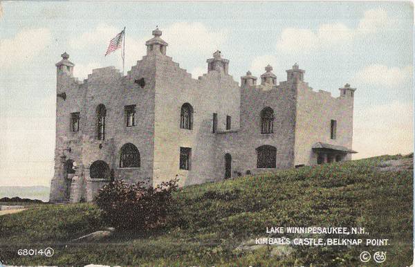
__________________
|
|
|
|
|
|
05-04-2020, 05:34 PM
|
#12 | |
|
Member

Join Date: Jan 2005
Posts: 39
Thanks: 0
Thanked 12 Times in 8 Posts
|
Quote:
|
|
|
|
|
| The Following User Says Thank You to WeirsGuard For This Useful Post: | ||
gillygirl (05-06-2020) | ||
|
04-21-2020, 01:59 PM
|
#13 |
|
Senior Member

Join Date: Jan 2009
Posts: 275
Thanks: 589
Thanked 205 Times in 129 Posts
|
In the first pic just over the bridge on the right is the old McGraths general store before the furnace blew up and it burned. The owner Pete McGrath was in the building at the time he was hurt badly, its now Irwin Marine. Over on the right is the old roller skating rink with Alton Bay on the roof, its now condos.
|
|
|
|
|
04-21-2020, 04:24 PM
|
#14 |
|
Senior Member
Join Date: Jul 2002
Location: Rock Haven Lake - West Newfield, ME
Posts: 5,367
Thanks: 374
Thanked 1,057 Times in 495 Posts
|
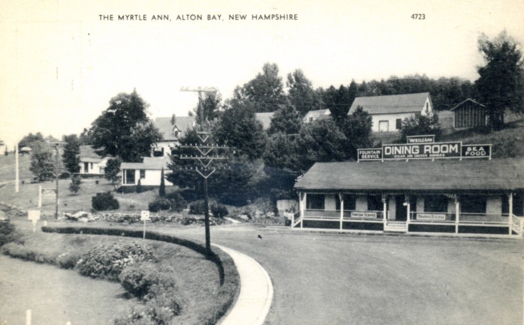
The Myrtle Ann circa 1945
__________________
|
|
|
|
|
04-21-2020, 04:28 PM
|
#15 |
|
Senior Member
Join Date: Jul 2002
Location: Rock Haven Lake - West Newfield, ME
Posts: 5,367
Thanks: 374
Thanked 1,057 Times in 495 Posts
|
McGrath's Store......before that it was Wilson's Store
 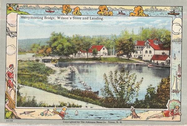 Sign says "Alton Bay Yacht Club" 
__________________
|
|
|
|
|
04-21-2020, 05:21 PM
|
#16 |
|
Senior Member
Join Date: Jun 2005
Location: Exeter NH
Posts: 604
Thanks: 0
Thanked 1,032 Times in 227 Posts
|
I don't know where these great pictures come from but thanks to all. I am surprised regularly by the posts of such old pictures. I find them fascinating.
These pictures-all of them-are amazing. What I'd give to be able to go back in time and walk through say, one of the grand hotels in Ctr. Harbor or the Weirs or on Long Island for starters-or go for a flight with Bob Fogg, among many other things, like taking a sweet HackerCraft out for dinner at the Weirs on a warm summer evening. Wow. Such a pure simple time. |
|
|
|
| The Following 3 Users Say Thank You to Diver1111 For This Useful Post: | ||
|
04-22-2020, 11:48 AM
|
#17 | |
|
Senior Member
Join Date: Mar 2006
Location: Merrimack and Welch Island
Posts: 4,420
Thanks: 1,368
Thanked 1,638 Times in 1,070 Posts
|
Quote:
https://www.seacoastonline.com/artic...NEWS/160409620 |
|
|
|
|
|
04-22-2020, 11:15 AM
|
#18 | |
|
Senior Member
Join Date: Jul 2002
Location: Rock Haven Lake - West Newfield, ME
Posts: 5,367
Thanks: 374
Thanked 1,057 Times in 495 Posts
|
Quote:
There have actually been three fires at the campground; 1945, 1967, and one more recently. 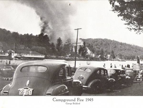 Follow this link for a history of the campground and more information about the fires. https://www.winnipesaukee.com/forums...n+camp+meeting
__________________
|
|
|
|
|
|
04-22-2020, 01:29 PM
|
#19 |
|
Senior Member
Join Date: May 2004
Posts: 962
Thanks: 495
Thanked 274 Times in 175 Posts
|
The date on the banner head of the newspaper is Friday, August 24, 1945. 🐻
|
|
|
|
|
04-22-2020, 02:14 PM
|
#20 |
|
Senior Member
Join Date: May 2004
Posts: 962
Thanks: 495
Thanked 274 Times in 175 Posts
|
Yes, we eat carrots. However, we prefer honey though it may have an occasional stingy flavor. 🐻
|
|
|
|
|
04-12-2020, 02:24 PM
|
#21 | |
|
Senior Member

Join Date: Apr 2004
Posts: 604
Thanks: 298
Thanked 431 Times in 142 Posts
|
Quote:
http://weirsbeach.com/services/chamb...irs-beach-map/ look at location 26 north of The Weirs which is entitled: Rose-Edward Lodge and Cabins
__________________
Lake Winni - The only place I want to be during the summer. 
|
|
|
|
|
| The Following User Says Thank You to Senter Cove Guy For This Useful Post: | ||
Top-Water (04-12-2020) | ||
|
| Bookmarks |
|
|


 Hybrid Mode
